Maps of Weiden in der Oberpfalz

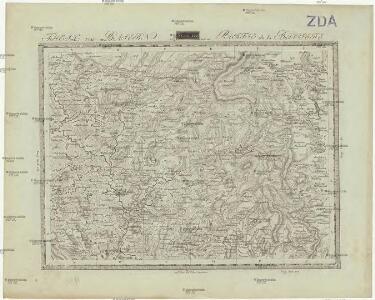
Theil von Baierno
Bavorsko (Německo) im Verlage des Geogr. Instituts
Pfraumberg.
from Spezialkarte der osterreichisch-ungarischen Monarchie.
Pfraumberg
1 : 75000 Poběžovice (Domažlice, Česko : oblast) Kimlein K. u. k. militär-geographisches Institut
Pfraumberg
1 : 75000 Poběžovice (Domažlice, Česko : oblast) Kimlein K. u. k. Militärgeographisches Institut
Pfraumberg
1 : 75000 Přimda-oblast (Česko) K. u. k. Militärgeographisches Institut
III. vojenské mapování 4149
1 : 75000
Podrobná mapa Království českého
1 : 100000 Pavlův Studenec (Česko : zaniklá obec) Srp, Jan Jaroslav Bursík
Vilímkovy místopisné mapy zemí Koruny české
1 : 100000 Pavlův Studenec (Česko : zaniklá obec) Srp, Jan Jos. R. Vilímek

[Kartenblatt]
1 : 25000 Rozvadov (Česko : oblast) Reichsamt für Landesaufnahme
[Kartenblatt]
1 : 25000 Bělá nad Radbuzou (Česko : oblast) Reichsamt für Landesaufnahme
Gradkartenblatt
1 : 25000 Rozvadov-oblast (Česko) Bulla, Eduard

III. vojenské mapování 4149/1
1 : 25000

Bestandeskarte des Hauptcomplexes der Domaine Tachau
1 : 29000 Tachov-oblast (Česko) Anderlik, Otto Verlag des böhm. Forstvereins
Uibersichtskarte der Herrschaft Tachau
Tachov-oblast (Česko) Waraus, E. André Verlag des böhm. Forstvereins

Lesní přehledová mapa velkostatku Tachov
1 : 29327
Přehledová mapa revírů Horní Výšina, Jalový Dvůr, Obora, Milíře, Pavlův Studenec, Zlatý Potok, Nový Losimtál
1 : 22942
Generalkarte der sämtlichen obrigkeitlichen Herrschaft Mayerhöfer Waldungen
Rozvadov-oblast (Česko) Biedermann, Kurt Walter, Maxmilian
Meßtischblatt 6440 : Moosbach, 1943
1 : 250000 Moosbach. - Aufn. 1932, hrsg. 1935, bericht. 1941, Ausg. 1943, bereinigt 1943. - 1:25000. - München: Hauptvermessungsabteilung XIII, 1943. - 1 Kt.
Meßtischblatt 149 : Flossenbürg, 1936
1 : 250000 Flossenbürg. - Aufn. 1923, Ausg. 1926, Nachtr. 1936. - 1:25000. - München: Topograph. Zweigstelle d. Bayer. Landes, 1936. - 1 Kt.
Meßtischblatt 6540 : Oberviechtach, 1941
1 : 250000 Oberviechtach. - Aufn. 1932 u. 1934, hrsg. 1937, letzte Nachtr. 1941, Ausg. 1943. - 1:25000. - München: Hauptvermessungsabt. XIII, 1941. - 1 Kt.
Meßtischblatt 6539 : Nabburg, 1937
1 : 250000 Nabburg. - Aufn. 1934, Ausg. 1937. - 1:25000. - München: Topograph. Zweigstelle d. Bayer. Landesvermessungsamts, 1937. - 1 Kt.
Meßtischblatt 6538 : Schmidgaden, 1937
1 : 250000 Schmidgaden. - Aufn. 1933, Ausg. 1937. - 1:25000. - München: Hauptvermessungsabt. XIII, 1937. - 1 Kt.
Porostní mapa lesního statku Ostrůvek
1 : 11520
Porostní mapa revíru Zlatý Potok
1 : 11520
Neudorf - c5234-1-007 - Kaiserpflichtexemplar der Landkarten des stabilen Katasters
1 : 2880
Neudorf - c5234-1-005 - Kaiserpflichtexemplar der Landkarten des stabilen Katasters
1 : 2880
Neudorf - c5234-1-011 - Kaiserpflichtexemplar der Landkarten des stabilen Katasters
1 : 2880
Neudorf - c5234-1-008 - Kaiserpflichtexemplar der Landkarten des stabilen Katasters
1 : 2880
Neudorf - c5234-1-015 - Kaiserpflichtexemplar der Landkarten des stabilen Katasters
1 : 2880
Neudorf - c5234-1-002 - Kaiserpflichtexemplar der Landkarten des stabilen Katasters
1 : 2880
Neudorf - c5234-1-009 - Kaiserpflichtexemplar der Landkarten des stabilen Katasters
1 : 2880
Neudorf - c5234-1-013 - Kaiserpflichtexemplar der Landkarten des stabilen Katasters
1 : 2880
Neudorf - c5234-1-001 - Kaiserpflichtexemplar der Landkarten des stabilen Katasters
1 : 2880
Neudorf - c5234-1-014 - Kaiserpflichtexemplar der Landkarten des stabilen Katasters
1 : 2880
Neudorf - c5234-1-003 - Kaiserpflichtexemplar der Landkarten des stabilen Katasters
1 : 2880
Neudorf - c5234-1-012 - Kaiserpflichtexemplar der Landkarten des stabilen Katasters
1 : 2880
Neudorf - c5234-1-010 - Kaiserpflichtexemplar der Landkarten des stabilen Katasters
1 : 2880
Neudorf - c5234-1-006 - Kaiserpflichtexemplar der Landkarten des stabilen Katasters
1 : 2880