Maps of Landkreis Wittmund

38. Wilhelmshaven, uit: Topographische Uebersichtskarte des Deutschen Reiches / herausgegeben v. d. Kartogr. Abt. d. Königl. Preuß. Landesaufnahme
1 : 200000 titelvariant: Topogr. Übersichtskarte des Deutschen Reiches; Annotatie: Titel boven bladen ook: Topogr. Übersichtskarte des Deutschen Reiches; Annotatie geografische gegevens: Op elk blad twee maatstokken: 10 Kilometer = 5,5 cm; 1 geogr. Meile = 3,6 cm; Legenda onder op elk blad Königlich Preußische Landesaufnahme. Kartographische Abtheilung [S.l : Königlich Preußische Landesaufnahme, Kartographische Abtheilung]
141. Esens. (Germany)
1 : 100000 Reichsamt fur Landesaufnahme
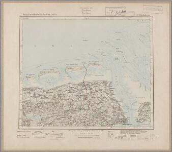
142. Wilhelmshaven. (Germany)
1 : 100000 Reichsamt fur Landesaufnahme
Composite: 142. Wilhelmshaven. (Germany)
1 : 100000 Reichsamt fur Landesaufnahme
Composite: 141. Esens. (Germany)
1 : 100000 Reichsamt fur Landesaufnahme
Composite: 109. Wangeroog. (Germany)
1 : 100000 Reichsamt fur Landesaufnahme
108. Spiekeroog. (Germany)
1 : 100000 Reichsamt fur Landesaufnahme
109. Wangeroog. (Germany)
1 : 100000 Reichsamt fur Landesaufnahme
Composite: 108. Spiekeroog. (Germany)
1 : 100000 Reichsamt fur Landesaufnahme
Meßtischblatt 1019 : Eckwarden, 1892
1 : 250000 Eckwarden. - Aufn. 1891. - 1:25000. - [Berlin]: Reichsamt für Landesaufnahme, 1892. - 1 Kt.
Meßtischblatt 1017 : Jever, 1893
1 : 250000 Jever. - Aufn. 1891. - 1:25000. - [Berlin]: Reichsamt für Landesaufnahme, 1893. - 1 Kt.
Meßtischblatt 1018 : Wilhelmshaven, 1935
1 : 250000 Wilhelmshaven. - Hrsg. 1892, bericht. 1917, einz. Nachtr. 1929. - 1:25000. - [Berlin]: Reichsamt für Landesaufnahme, 1935. - 1 Kt.
Meßtischblatt 1018 : Wilhelmshaven, 1917
1 : 250000 Wilhelmshaven. - Aufn. 1891, hrsg. 1892. - 1:25000. - [Berlin]: Reichsamt für Landesaufnahme, 1917. - 1 Kt.
Meßtischblatt 1014 : Westerholt, 1893
1 : 250000 Westerholt. - Aufn. 1891. - 1:25000. - [Berlin]: Reichsamt für Landesaufnahme, 1893. - 1 Kt.
Meßtischblatt 923 : Langwarden, 1892
1 : 250000 Langwarden. - Aufn. 1891. - 1:25000. - [Berlin]: Reichsamt für Landesaufnahme, 1892. - 1 Kt.
Meßtischblatt 921 : Hohenkirchen, 1893
1 : 250000 Hohenkirchen. - Aufn. 1891. - 1:25000. - [Berlin]: Reichsamt für Landesaufnahme, 1893. - 1 Kt.
Meßtischblatt 826/922 : Hooksiel, 1893
1 : 250000 Hooksiel. - Aufn. 1891. - 1:25000. - [Berlin]: Reichsamt für Landesaufnahme, 1893. - 1 Kt.
Meßtischblatt 920 : Karolinensiel, 1893
1 : 250000 Karolinensiel. - Aufn. 1891. - 1:25000. - [Berlin]: Reichsamt für Landesaufnahme, 1893. - 1 Kt.
Meßtischblatt 919 : Esens, 1893
1 : 250000 Esens. - Aufn. 1891. - 1:25000. - [Berlin]: Reichsamt für Landesaufnahme, 1893. - 1 Kt.
Meßtischblatt Dornum
1 : 250000 Dornum. - berichtigt 1939, Ausg. 1942. - 1:25000. - [Berlin]: Reichsamt für Landesaufnahme, 1942. - 1 Kt.
Meßtischblatt 2213 : Wangerooge, 1940
1 : 250000 Wangerooge. - berichtigt 1938, Ausg. 1940. - 1:25000. - [Berlin]: Reichsamt für Landesaufnahme, 1940. - 1 Kt.
Meßtischblatt 825 : Wangerooge, 1917
1 : 250000 Wangerooge. - Aufn. 1891, hrsg. 1892, Auflagendr. 1917. - 1:25000. - [Berlin]: Reichsamt für Landesaufnahme, 1917. - 1 Kt.
Meßtischblatt 824 : Spiekeroog, 1918
1 : 250000 Spiekeroog. - Aufn. 1891, hrsg. 1892, Auflagendr. 1918. - 1:25000. - [Berlin]: Reichsamt für Landesaufnahme, 1918. - 1 Kt.
Meßtischblatt 823 : Langeoog, 1918
1 : 250000 Langeoog. - Aufn. 1891, hrsg. 1892, Auflagendr. 1918. - 1:25000. - [Berlin]: Reichsamt für Landesaufnahme, 1918. - 1 Kt.
Meßtischblatt 822 : Baltrum, 1930
1 : 250000 Baltrum. - Hrsg. 1892, bericht. 1930. - 1:25000. - [Berlin]: Reichsamt für Landesaufnahme, 1930. - 1 Kt.
Germany [Town plans of], Wilhelmshaven
Town plans of Germany, GSGS 4480. Great Britain. War Office. [London] : War Office
[4], uit: Hydro-Oro und Chorographische General Karte des Koenigreichs der Niederlande und der angrenzenden Länder bis Paris : mit der Angabe der Kunst und Heer-Strassen und der Entfernung der Poststationen / ... zusammengetragen und reducirt von ... Wilhelm Müller
1 : 400000 titelvariant: Generalkarte des Koenigreichs Hannover; Annotatie: 1e supplement bij: Generalkarte des Koenigreichs Hannover (1818) Müller, Wilhelm (fl. 1818) [Hannover : Wilhelm Müller]
Wilhelmshaven 32, uit: Special-Karte von Mittel-Europa / nach amtlichen Quellen bearbeitet von W. Liebenow
1 : 300000 titelvariant: W. Liebenow's Mittel-Europa; Annotatie: Titel boven de bladen: W. Liebenow's Mittel-Europa Johannes Wilhelm Liebenow 1822-1897 Frankfurt a. M. : Ludwig Ravenstein
Wilhelmshaven 32, uit: [W. Liebenow's Special-Karte von Mittel-Europa]
1 : 300000 titelvariant: W. Liebenow's Mittel-Europa; Annotatie: Titel boven de bladen: W. Liebenow's Mittel-Europa Johannes Wilhelm Liebenow 1822-1897 Hannover : Hermann Oppermann