Maps of Landkreis Wittmund

141. Esens. (Germany)
1 : 100000 Reichsamt fur Landesaufnahme
Composite: 141. Esens. (Germany)
1 : 100000 Reichsamt fur Landesaufnahme
Meßtischblatt 1014 : Westerholt, 1893
1 : 250000 Westerholt. - Aufn. 1891. - 1:25000. - [Berlin]: Reichsamt für Landesaufnahme, 1893. - 1 Kt.
Meßtischblatt 920 : Karolinensiel, 1893
1 : 250000 Karolinensiel. - Aufn. 1891. - 1:25000. - [Berlin]: Reichsamt für Landesaufnahme, 1893. - 1 Kt.
Meßtischblatt 919 : Esens, 1893
1 : 250000 Esens. - Aufn. 1891. - 1:25000. - [Berlin]: Reichsamt für Landesaufnahme, 1893. - 1 Kt.
Meßtischblatt Dornum
1 : 250000 Dornum. - berichtigt 1939, Ausg. 1942. - 1:25000. - [Berlin]: Reichsamt für Landesaufnahme, 1942. - 1 Kt.
38. Wilhelmshaven, uit: Topographische Uebersichtskarte des Deutschen Reiches / herausgegeben v. d. Kartogr. Abt. d. Königl. Preuß. Landesaufnahme
1 : 200000 titelvariant: Topogr. Übersichtskarte des Deutschen Reiches; Annotatie: Titel boven bladen ook: Topogr. Übersichtskarte des Deutschen Reiches; Annotatie geografische gegevens: Op elk blad twee maatstokken: 10 Kilometer = 5,5 cm; 1 geogr. Meile = 3,6 cm; Legenda onder op elk blad Königlich Preußische Landesaufnahme. Kartographische Abtheilung [S.l : Königlich Preußische Landesaufnahme, Kartographische Abtheilung]
Composite: 173. Aurich. (Germany)
1 : 100000 Reichsamt fur Landesaufnahme
Meßtischblatt 822 : Baltrum, 1930
1 : 250000 Baltrum. - Hrsg. 1892, bericht. 1930. - 1:25000. - [Berlin]: Reichsamt für Landesaufnahme, 1930. - 1 Kt.
Meßtischblatt 823 : Langeoog, 1918
1 : 250000 Langeoog. - Aufn. 1891, hrsg. 1892, Auflagendr. 1918. - 1:25000. - [Berlin]: Reichsamt für Landesaufnahme, 1918. - 1 Kt.
Meßtischblatt 824 : Spiekeroog, 1918
1 : 250000 Spiekeroog. - Aufn. 1891, hrsg. 1892, Auflagendr. 1918. - 1:25000. - [Berlin]: Reichsamt für Landesaufnahme, 1918. - 1 Kt.
Meßtischblatt 1017 : Jever, 1893
1 : 250000 Jever. - Aufn. 1891. - 1:25000. - [Berlin]: Reichsamt für Landesaufnahme, 1893. - 1 Kt.
Meßtischblatt 921 : Hohenkirchen, 1893
1 : 250000 Hohenkirchen. - Aufn. 1891. - 1:25000. - [Berlin]: Reichsamt für Landesaufnahme, 1893. - 1 Kt.
Meßtischblatt 1108 : Wiesede, 1917
1 : 250000 Wiesede. - Aufn. 1897, hrsg. 1898, Auflagedr. 1917. - 1:25000. - [Berlin]: Reichsamt für Landesaufnahme, 1917. - 1 Kt.
Meßtischblatt 1107 : Holtrop, 1917
1 : 250000 Holtrop. - Aufn. 1897, hrsg. 1899, Auflagedr. 1917. - 1:25000. - [Berlin]: Reichsamt für Landesaufnahme, 1917. - 1 Kt.
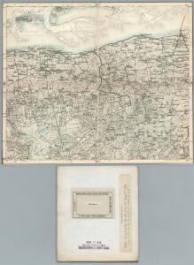
Meßtischblatt 1106 : Aurich, 1933
1 : 250000 Aurich. - Aufn. 1897, Nachtr. 1925, gedr. [19]33. - 1:25000. - [Berlin]: Reichsamt für Landesaufnahme, 1933. - 1 Kt.
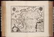
Typvs Frisiae Orientalis à Dullarto sinu atque Amasi ostio ad Iada usque fl. singulari studio ac industria concinnat. et vivum expresso
1 : 200000 Mollova mapová sbírka Visscher, Claes Jansz. Visscher, Claes Janszoon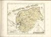

Frisia orientalis
1 : 213000 Frísko Allard, Carel Covens et Mortier
Frisia orientalis
1 : 200000 Carolus Allard excudit Amstelodami : [Allard]
Frisia Orientalis
1 : 210000 Mollova mapová sbírka Allard, Carel Allard, Carel

Neue geographische Charte von den Furstenthum Ostfries und Harrlingerland : nach geometrischen und trigonometrischen vermessungen, welche auf die astronomischen observationen des Herren Schrötter und Olbers im Herzogthum Bremen gegründet, und unter landsherrlicher Approbation, von den ostfriesischen Landes-Staenden bewerckstelliget worden / aufgenommen und bearbeitet in Jahren 1798, 1799, 1800, 1801, und 1802 durch den vormaligen hollandischen Artillerie Capitain W. Camp ; (buiten kader) C. van Baarsel sculp
1 : 300000 Annotatie geografische gegevens: Met 3 schaalstokken; Legenda Willem Petrus del Campo gen. Camp 1761-1855; Cornelis van Baarsel 1761-1826 [S.l. : s.n.]
Typvs Frisiae Orientalis
1 : 250000 Mollova mapová sbírka Emmius, Ubbo Rogiers, Salomon Schenk, Peter I
Typvs Frisiae Orientalis
1 : 250000 Mollova mapová sbírka Emmius, Ubbo Blaeu, Willem Jansz.
Hanc Frisiae Orientalis Tabulam
1 : 210000 Mollova mapová sbírka Schneider, Ruprecht Adam Homann, Johann Christoph
Neue geographische Special Karte von dem Fürstenthum Ostfries- und dem Harrlingerlande : nach geometrischen und trigonometrischen Vermessungen ... / aufgenommen und bearb. ... durch W. Camp und dessen beiden Gehülfen ... H. Bunnik und W. van der Linden ; gestochen von Carl Jättnig in Berlin 1804
1 : 120000 Annotatie geografische gegevens: Opname: 1798-1802 Willem Petrus del Campo gen. Camp 1761-1855; Bunnik, H.; Linden, W. van der (fl. 1804); Carl Jaettnig 1795-1835 fl. [Berlin : Carl Jättnig]
TYPVS | FRISIÆ | ORIENTALIS
Auctore | Vbbone Emmio. [Amsterdam : Joan Blaeu]
Typus Frisiae Orientalis. [Karte] Rideriae Portionis [...] [Nebenkarte], in: Theatrum orbis terrarum, sive, Atlas novus, Bd. 1, S. 203.
1 Karte aus Atlas Blaeu, Joan Blaeu, Willem Janszoon