Maps of Hamburg-Mitte

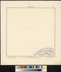
Meßtischblatt 923 : Langwarden, 1892
1 : 250000 Langwarden. - Aufn. 1891. - 1:25000. - [Berlin]: Reichsamt für Landesaufnahme, 1892. - 1 Kt.
Composite: 142. Wilhelmshaven. (Germany)
1 : 100000 Reichsamt fur Landesaufnahme
142. Wilhelmshaven. (Germany)
1 : 100000 Reichsamt fur Landesaufnahme
38. Wilhelmshaven, uit: Topographische Uebersichtskarte des Deutschen Reiches / herausgegeben v. d. Kartogr. Abt. d. Königl. Preuß. Landesaufnahme
1 : 200000 titelvariant: Topogr. Übersichtskarte des Deutschen Reiches; Annotatie: Titel boven bladen ook: Topogr. Übersichtskarte des Deutschen Reiches; Annotatie geografische gegevens: Op elk blad twee maatstokken: 10 Kilometer = 5,5 cm; 1 geogr. Meile = 3,6 cm; Legenda onder op elk blad Königlich Preußische Landesaufnahme. Kartographische Abtheilung [S.l : Königlich Preußische Landesaufnahme, Kartographische Abtheilung]
Nobilis Saxoniae Fl. Visurgis, cum Terris adjacentib. Ab Inclyta Brema, ad ostium maris. [Karte, Teil 2], in: Novus atlas absolutissimus, Bd. 2, S. 100.
1 Karte aus Atlas Janssonius Offizin
Celeberrimi Fluvii Albis nova delineatio [Karte, Teil 2], in: Le théâtre du monde, ou, Nouvel atlas contenant les chartes et descriptions de tous les païs de la terre, Bd. 1, S. 148.
1 Karte aus Atlas Blaeu, Willem Janszoon und Blaeu, Joan Blaeu, Willem Janszoon
Celeberrimi Fluvii Albis nova delineatio [Karte, Teil 2], in: Theatrum orbis terrarum, sive, Atlas novus, Bd. 1, S. 182.
1 Karte aus Atlas Blaeu, Joan Blaeu, Willem Janszoon
OLDENBVRG | COMITATVS.
E. Sijmonsz. Hamersveldt sculp. [Amsterdam : Joan Blaeu]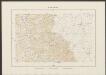
Oldenburg Comitatus [Karte], in: Theatrum orbis terrarum, sive, Atlas novus, Bd. 1, S. 200.
1 Karte aus Atlas Blaeu, Joan Blaeu, Willem Janszoon
Nobilis Saxoniae Fl. Visurgis, cum Terris adjacentib.
1 : 110000 Mollova mapová sbírka Loon, Jan van Schenk, Peter I
Nobilis Saxoniae Fl. Visurgis, cum Terris adjacentib.
1 : 110000 Mollova mapová sbírka Loon, Jan van Janssonius, Johannes I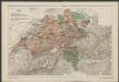
Oldenburg Comitatus [Karte], in: Gerardi Mercatoris et I. Hondii Newer Atlas, oder, Grosses Weltbuch, Bd. 1, S. 155.
1 Karte aus Atlas Mercator, Gerhard und Hondius, Jodocus Jansson, Jan
Oldenburg Comitatus [Karte], in: Le théâtre du monde, ou, Nouvel atlas contenant les chartes et descriptions de tous les païs de la terre, Bd. 1, S. 154.
1 Karte aus Atlas Blaeu, Willem Janszoon und Blaeu, Joan Blaeu, Willem Janszoon
Oldenburg Comitatus [Karte], in: Novus Atlas, das ist, Weltbeschreibung, Bd. 1, S. 123.
1 Karte aus Atlas Blaeu, Joan Blaeu, Willem Janszoon
Oldenbvrg Comit.
1 : 250000 Mollova mapová sbírka Michaelis, Laurentius Plantin, Christoph
Wilhelmshaven 32, uit: [W. Liebenow's Special-Karte von Mittel-Europa]
1 : 300000 titelvariant: W. Liebenow's Mittel-Europa; Annotatie: Titel boven de bladen: W. Liebenow's Mittel-Europa Johannes Wilhelm Liebenow 1822-1897 Hannover : Hermann Oppermann
Frisia orientalis
1 : 213000 Frísko Allard, Carel Covens et Mortier
Oldenburg Comitatus [Karte], in: Novus atlas absolutissimus, Bd. 2, S. 109.
1 Karte aus Atlas Janssonius Offizin

Hanc Frisiae Orientalis Tabulam
1 : 210000 Mollova mapová sbírka Schneider, Ruprecht Adam Homann, Johann Christoph
Wilhelmshaven 32, uit: Special-Karte von Mittel-Europa / nach amtlichen Quellen bearbeitet von W. Liebenow
1 : 300000 titelvariant: W. Liebenow's Mittel-Europa; Annotatie: Titel boven de bladen: W. Liebenow's Mittel-Europa Johannes Wilhelm Liebenow 1822-1897 Frankfurt a. M. : Ludwig Ravenstein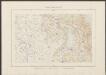
Typus Frisiae Orientalis. [Karte] Rideriae Portionis [...] [Nebenkarte], in: Theatrum orbis terrarum, sive, Atlas novus, Bd. 1, S. 203.
1 Karte aus Atlas Blaeu, Joan Blaeu, Willem Janszoon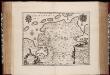
Typvs Frisiæ Orientalis / auctore Vbbone Emmio
1 : 250000 Annotatie: Met wapens; Origineel is Blad 79 in atlas factice; Annotatie geografische gegevens: Met schaalstok Willem Jansz Blaeu 1571-1638 Amstelodami : Guiljelm. Blaeuw excudit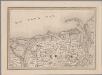
[4], uit: Hydro-Oro und Chorographische General Karte des Koenigreichs der Niederlande und der angrenzenden Länder bis Paris : mit der Angabe der Kunst und Heer-Strassen und der Entfernung der Poststationen / ... zusammengetragen und reducirt von ... Wilhelm Müller
1 : 400000 titelvariant: Generalkarte des Koenigreichs Hannover; Annotatie: 1e supplement bij: Generalkarte des Koenigreichs Hannover (1818) Müller, Wilhelm (fl. 1818) [Hannover : Wilhelm Müller]
Tabula Frisiæ orientalis
1 Karte : Kupferdruck ; 47 x 56 cm Homann; Sanson; Coldewey; Allard; Emmius ex officina Ioh. Christoph: Homanni M. D
Tabula Frisiæ orientalis
1 Karte : Kupferdruck ; 47 x 56 cm Homann; Sanson; Coldewey; Allard; Emmius ex officina Ioh. Christoph: Homanni M. D
Tabula Frisiæ orientalis
1 Karte : Kupferdruck ; 47 x 56 cm Homann; Sanson; Coldewey; Allard; Emmius ex officina Ioh. Christoph: Homanni M. D
Typus Frisiae Orientalis. [Karte] Rideriae Portionis [...] [Nebenkarte], in: Novus atlas absolutissimus, Bd. 2, S. 112.
1 Karte aus Atlas Janssonius Offizin
Typus Frisiae Orientalis. [Karte] Rideriae Portionis [...] [Nebenkarte], in: Le théâtre du monde, ou, Nouvel atlas contenant les chartes et descriptions de tous les païs de la terre, Bd. 1, S. 157.
1 Karte aus Atlas Blaeu, Willem Janszoon und Blaeu, Joan Blaeu, Willem Janszoon
Oldenbvrg Comitatvs.
1 : 190000 Mollova mapová sbírka Aveele, Johannes van den