Maps of gmina Ustka

14. Stolpmünde, uit: Topographische Uebersichtskarte des Deutschen Reiches / herausgegeben v. d. Kartogr. Abt. d. Königl. Preuß. Landesaufnahme
1 : 200000 titelvariant: Topogr. Übersichtskarte des Deutschen Reiches; Annotatie: Titel boven bladen ook: Topogr. Übersichtskarte des Deutschen Reiches; Annotatie geografische gegevens: Op elk blad twee maatstokken: 10 Kilometer = 5,5 cm; 1 geogr. Meile = 3,6 cm; Legenda onder op elk blad Königlich Preußische Landesaufnahme. Kartographische Abtheilung [S.l : Königlich Preußische Landesaufnahme, Kartographische Abtheilung]
Composite: 44. Stolpmunde. (Germany)
1 : 100000 Reichsamt fur Landesaufnahme
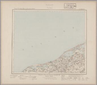
44. Stolpmunde. (Germany)
1 : 100000 Reichsamt fur Landesaufnahme
43. Lanzig. (Germany)
1 : 100000 Reichsamt fur Landesaufnahme
Meßtischblatt 1468 : Freist, 1939
1 : 250000 Freist. - Aufn. 1889, hrsg. 1891, bericht. 1939. - 1:25000. - [Berlin]: Reichsamt für Landesaufnahme, 1939. - 1 Kt.
Meßtischblatt 1467 : Stolpmünde, 1937
1 : 250000 Stolpmünde. - Hrsg. 1891, einz. Nachtr. 1929. - 1:25000. - [Berlin]: Reichsamt für Landesaufnahme, 1937. - 1 Kt.
Meßtischblatt 263, neue Nr. 1465 : Lanzig, 1937
1 : 250000 Lanzig. - Hrsg. 1890, bericht. 1935. - 1:25000. - [Berlin]: Reichsamt für Landesaufnahme, 1937. - 1 Kt.
Meßtischblatt 1464 : Vitte, 1940
1 : 250000 Vitte. - Hrsg. 1890, bericht. 1939. - 1:25000. - [Berlin]: Reichsamt für Landesaufnahme, 1940. - 1 Kt.
Meßtischblatt 1469 : Dammen, 1938
1 : 250000 Dammen. - Hrsg. 1891, Nachtr. 1924, redakt. Änd. 1938. - 1:25000. - [Berlin]: Reichsamt für Landesaufnahme, 1938. - 1 Kt.
Meßtischblatt 264 : Saleske, 1937
1 : 250000 Saleske. - Hrsg. 1891, bericht. 1934. - 1:25000. - [Berlin]: Reichsamt für Landesaufnahme, 1937. - 1 Kt.
Meßtischblatt 215 : Wobesde, 1928
1 : 250000 Wobesde. - Hrsg. 1891, einz. Nachtr. 1928. - 1:25000. - [Berlin]: Reichsamt für Landesaufnahme, 1928. - 1 Kt.
Meßtischblatt 1367 : Neu-Strand, 1890
1 : 250000 Neu-Strand. - Aufn. 1889. - 1:25000. - [Berlin]: Reichsamt für Landesaufnahme, 1890. - 1 Kt.
Meßtischblatt 1369 : Schmolsin, 1942
1 : 250000 Schmolsin. - Aufn. 1889, hrsg. 1891, bericht. 1939. - 1:25000. - [Berlin]: Reichsamt für Landesaufnahme, 1942. - 1 Kt.
Meßtischblatt 1269 : Scholpin, 1943
1 : 250000 Scholpin. - Aufn. 1889/1939, hrsg. 1891, bericht. 1939. - 1:25000. - [Berlin]: Reichsamt für Landesaufnahme, 1943. - 1 Kt.
Stolpmünde 15, uit: Special-Karte von Mittel-Europa / nach amtlichen Quellen bearbeitet von W. Liebenow
1 : 300000 titelvariant: W. Liebenow's Mittel-Europa; Annotatie: Titel boven de bladen: W. Liebenow's Mittel-Europa Johannes Wilhelm Liebenow 1822-1897 Frankfurt a. M. : Ludwig Ravenstein

15. Lauenburg i. Pom., uit: Topographische Uebersichtskarte des Deutschen Reiches / herausgegeben v. d. Kartogr. Abt. d. Königl. Preuß. Landesaufnahme
1 : 200000 titelvariant: Topogr. Übersichtskarte des Deutschen Reiches; Annotatie: Titel boven bladen ook: Topogr. Übersichtskarte des Deutschen Reiches; Annotatie geografische gegevens: Op elk blad twee maatstokken: 10 Kilometer = 5,5 cm; 1 geogr. Meile = 3,6 cm; Legenda onder op elk blad Königlich Preußische Landesaufnahme. Kartographische Abtheilung [S.l : Königlich Preußische Landesaufnahme, Kartographische Abtheilung]
[Stargard]
Stargard Szczeciński
Danzig
1 : 600000 Opitz, Carl Solbrig
Mapa samochodowa Rzeczypospolitej Polskiej
1 : 300000 Gdaňsk-oblast (Polsko) wydanie Wojskowego instytutu geograficznego
Sect. 3: Rügenwalde, uit: Geologische Karte des Deutschen Reichs in 27 Blaettern / [von] Richard Lepsius ; Red. von C. Vogel
1 : 500000 Annotatie: Blad 18 ontbreekt; Een aantal bladen op linnen; Een aantal bladen gereviseerd 1913-1914; Annotatie geografische gegevens: Met schaalstokken o.a. in kilometers; Legenda Carl Vogel 1828-1897 Gotha : Justus Perthes

67. Stolp. (Germany)
1 : 100000 Reichsamt fur Landesaufnahme
25. Leba. (Germany)
1 : 100000 Reichsamt fur Landesaufnahme
Composite: 67. Stolp. (Germany)
1 : 100000 Reichsamt fur Landesaufnahme
Meßtischblatt 1569 : Sageritz, 1938
1 : 250000 Sageritz. - Hrsg. 1891, bericht. 1935, redakt. Änd. 1938. - 1:25000. - [Berlin]: Reichsamt für Landesaufnahme, 1938. - 1 Kt.
Meßtischblatt 1568 : Stolp, 1938
1 : 250000 Stolp. - Hrsg. 1890, bericht. 1935, redakt. Änd. 1938. - 1:25000. - [Berlin]: Reichsamt für Landesaufnahme, 1938. - 1 Kt.
Meßtischblatt 1567 : Zitzewitz, 1935
1 : 250000 Zitzewitz. - Hrsg. 1890, bericht. 1935. - 1:25000. - [Berlin]: Reichsamt für Landesaufnahme, 1935. - 1 Kt.
Meßtischblatt 319 : Peest, 1934
1 : 250000 Peest. - Hrsg. 1891, bericht. 1934. - 1:25000. - [Berlin]: Reichsamt für Landesaufnahme, 1934. - 1 Kt.