Maps of gmina Krokowa

15. Lauenburg i. Pom., uit: Topographische Uebersichtskarte des Deutschen Reiches / herausgegeben v. d. Kartogr. Abt. d. Königl. Preuß. Landesaufnahme
1 : 200000 titelvariant: Topogr. Übersichtskarte des Deutschen Reiches; Annotatie: Titel boven bladen ook: Topogr. Übersichtskarte des Deutschen Reiches; Annotatie geografische gegevens: Op elk blad twee maatstokken: 10 Kilometer = 5,5 cm; 1 geogr. Meile = 3,6 cm; Legenda onder op elk blad Königlich Preußische Landesaufnahme. Kartographische Abtheilung [S.l : Königlich Preußische Landesaufnahme, Kartographische Abtheilung]
Composite: 27. Schwarzau. (Germany)
1 : 100000 Reichsamt fur Landesaufnahme
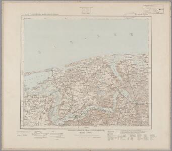
27. Schwarzau. (Germany)
1 : 100000 Reichsamt fur Landesaufnahme
Composite: 25. Leba. (Germany)
1 : 100000 Reichsamt fur Landesaufnahme
Meßtischblatt 1277 : Kußfeld, 1938
1 : 250000 Kußfeld. - Aufn. 1908, hrsg. 1909, letzte Nachtr. 1938. - 1:25000. - [Berlin]: Reichsamt für Landesaufnahme, 1938. - 1 Kt.
Messtischblatt Putzig
1 : 250000 Putzig. - Aufn. 1908, hrsg. 1910, letzte Nachtr. 1937. - 1:25000. - [Berlin]: Reichsamt für Landesaufnahme, 1940. - 1 Kt.
Meßtischblatt 172 : Leba, 1928
1 : 250000 Leba. - Hrsg. 1891, bericht. 1911, einz. Nachtr. 1928. - 1:25000. - [Berlin]: Reichsamt für Landesaufnahme, 1928. - 1 Kt.
Meßtischblatt 171 : Leba- See, 1891
1 : 250000 Leba- See. - Aufn. 1889. - 1:25000. - [Berlin]: Reichsamt für Landesaufnahme, 1891. - 1 Kt.
Meßtischblatt 176 : Mechau, 1890
1 : 250000 Mechau. - Aufn. 1875, einz. Nachtr. 1890. - 1:25000. - [Berlin]: Reichsamt für Landesaufnahme, 1890. - 1 Kt.
Meßtischblatt 1172/1272 : Sassin, 1939
1 : 250000 Sassin. - Aufn. 1889, hrsg. 1890, bericht. 1939. - 1:25000. - [Berlin]: Reichsamt für Landesaufnahme, 1939. - 1 Kt.
Meßtischblatt 1269 : Scholpin, 1943
1 : 250000 Scholpin. - Aufn. 1889/1939, hrsg. 1891, bericht. 1939. - 1:25000. - [Berlin]: Reichsamt für Landesaufnahme, 1943. - 1 Kt.
Composite: 26. Ossecken. (Germany)
1 : 100000 Reichsamt fur Landesaufnahme
Composite: 44. Stolpmunde. (Germany)
1 : 100000 Reichsamt fur Landesaufnahme
25. Leba. (Germany)
1 : 100000 Reichsamt fur Landesaufnahme
44. Stolpmunde. (Germany)
1 : 100000 Reichsamt fur Landesaufnahme
Composite: 47. Hela. (Germany)
1 : 100000 Reichsamt fur Landesaufnahme
47. Hela. (Germany)
1 : 100000 Reichsamt fur Landesaufnahme
Composite: 45. Lauenburg i Pom. (Germany)
1 : 100000 Reichsamt fur Landesaufnahme
Messtischblatt 135 : Wittenberg, 1928 Wittenberg i. Pommern
1 : 250000 Wittenberg i. Pommern. - Hrsg. 1877, einz. Nachtr. 1928. - 1:25000. - [Berlin]: Reichsamt für Landesaufnahme, 1928. - 1 Kt.
Messtischblatt 136 : Dembek, 1926 Dembeck
1 : 250000 Dembeck. - Aufn. 1875, einz. Nachtr. 1926. - 1:25000. - [Berlin]: Reichsamt für Landesaufnahme, 1926. - 1 Kt.
Messtischblatt 137 : Ostrau, 1877 Ostrau
1 : 250000 Ostrau. - Aufn. 1875. - 1:25000. - [Berlin]: Reichsamt für Landesaufnahme, 1877. - 1 Kt.
Messtischblatt 1176 : Rixhöft, 1938 Rixhöft
1 : 250000 Rixhöft. - Aufn. 1908, letzt. Nachtr. 1938. - 1:25000. - [Berlin]: Reichsamt für Landesaufnahme, 1908. - 1 Kt.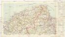
Mapa samochodowa Rzeczypospolitej Polskiej
1 : 300000 Gdaňsk-oblast (Polsko) wydanie Wojskowego instytutu geograficznego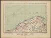
Danzig
1 : 600000 Opitz, Carl Solbrig

Svobodné město Gdansk (Danzig)
1 : 300000 Gdaňsk-oblast (Polsko) Jordán, V. O. Girgal
Hela 16, uit: Special-Karte von Mittel-Europa / nach amtlichen Quellen bearbeitet von W. Liebenow
1 : 300000 titelvariant: W. Liebenow's Mittel-Europa; Annotatie: Titel boven de bladen: W. Liebenow's Mittel-Europa Johannes Wilhelm Liebenow 1822-1897 Frankfurt a. M. : Ludwig Ravenstein
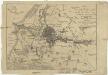
Die Stadt Dantzig mit ihren Gebiet und einigen umliegenden Gegenden nach den neuesten Karten
1 : 95000 Gdaňsk-oblast (Polsko)