Maps of Hajdú-Bihar

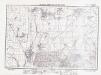
Debreczen 150, uit: Special-Karte von Mittel-Europa / nach amtlichen Quellen bearbeitet von W. Liebenow
1 : 300000 titelvariant: W. Liebenow's Mittel-Europa; Annotatie: Titel boven de bladen: W. Liebenow's Mittel-Europa Johannes Wilhelm Liebenow 1822-1897 Frankfurt a. M. : Ludwig Ravenstein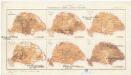
Magyarország mezögazdasági viszonyai
Maďarsko Homolka, Josef Posner Károly Lajos és fia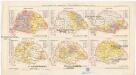
Magyarország népessége hitfelekezetek szerint 1890
Maďarsko Homolka, Josef Posner Károly Lajos és fia
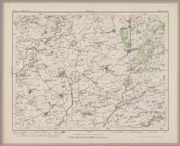
Hortobágy
1 : 240000 Národní park Hortobágy (Maďarsko) Homolka, Josef Posner Károly Lajos és fia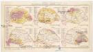
Magyarország népessége anyanyelv szerint
Maďarsko Homolka, Josef Posner Károly Lajos és fia
Hajdu-Szoboszlo und Esztar.
from Spezialkarte der osterreichisch-ungarischen Monarchie.
Debreczen.
from Spezialkarte der osterreichisch-ungarischen Monarchie.
N.-Bajom
1 : 75000 Biharnagybajom, Hajdú-Bihar
Püspök-Ladány
1 : 75000 Püspökladány, Hajdú-Bihar
Hajdú-Szoboszló
1 : 75000 Hajdúszoboszló, Hajdú-Bihar
Puspok-Ladany.; Spezialkarte der osterreichisch-ungarischen Monarchie.
from Spezialkarte der osterreichisch-ungarischen Monarchie. Austro-Hungarian Monarchy. Militärgeographisches Institut.,
Csege.; Spezialkarte der osterreichisch-ungarischen Monarchie.
from Spezialkarte der osterreichisch-ungarischen Monarchie. Austro-Hungarian Monarchy. Militärgeographisches Institut.,
N.-Bajom und Szeghalom (Ungarn).
from Spezialkarte der osterreichisch-ungarischen Monarchie.
Berettyo-Ujfalu und Koros-Tarjan.
from Spezialkarte der osterreichisch-ungarischen Monarchie.
Tisza-Roff.
from Spezialkarte der osterreichisch-ungarischen Monarchie.
Besenyo und Tisza-Fured.; Spezialkarte der osterreichisch-ungarischen Monarchie.
from Spezialkarte der osterreichisch-ungarischen Monarchie. Austro-Hungarian Monarchy. Militärgeographisches Institut.,
Besenyö und Tisza-Füred
1 : 75000 Tiszafüred, Umland Schrift und Gerippe v. Führer Miedl. Terrainschraffirung v. Joh. Le Gay Edl. v. Lierfels
Kis-Ujszállás
1 : 75000 Kisújszállás, Komitat Jász-Nagykun-Szolnok
Tisza-Roff
1 : 75000 Komitat Jász-Nagykun-Szolnok
Kis-Ujszallas und Mezo-Tur.
from Spezialkarte der osterreichisch-ungarischen Monarchie.
Polgar (Ungarn).
from Spezialkarte der osterreichisch-ungarischen Monarchie.
Nyiregyhaza und Hajdu-Nans.
from Spezialkarte der osterreichisch-ungarischen Monarchie.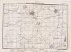
Lambert-Cholesky sheet 1973 (Mezosas)
1 : 20000 Romanian military topographic map sheet under Lambert-Cholensky projection Institutul Geografic Militar geo-spatial.org Institutul Geografic Militar
Lambert-Cholesky sheet 2075 (Pocsaj)
1 : 20000 Romanian military topographic map sheet under Lambert-Cholensky projection Institutul Geografic Militar geo-spatial.org Institutul Geografic Militar
Lambert-Cholesky sheet 2074 (Santăul Mare)
1 : 20000 Romanian military topographic map sheet under Lambert-Cholensky projection Direcția Topografică Militară geo-spatial.org Direcția Topografică Militară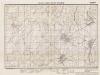
Lambert-Cholesky sheet 2177 (Bagamer)
1 : 20000 Romanian military topographic map sheet under Lambert-Cholensky projection Institutul Geografic Militar geo-spatial.org Institutul Geografic Militar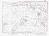
Lambert-Cholesky sheet 2073 (Tărian)
1 : 20000 Romanian military topographic map sheet under Lambert-Cholensky projection Institutul Geografic Militar geo-spatial.org Institutul Geografic Militar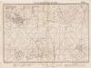
Lambert-Cholesky sheet 2176 (Ciocaia)
1 : 20000 Romanian military topographic map sheet under Lambert-Cholensky projection Institutul Geografic Militar geo-spatial.org Institutul Geografic Militar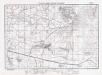
Lambert-Cholesky sheet 2175 (Diosig)
1 : 20000 Romanian military topographic map sheet under Lambert-Cholensky projection Institutul Geografic Militar geo-spatial.org Institutul Geografic Militar