Maps of Berettyóújfalui járás

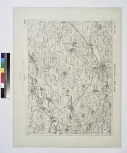
Berettyo-Ujfalu und Koros-Tarjan.
from Spezialkarte der osterreichisch-ungarischen Monarchie.
Lambert-Cholesky sheet 1973 (Mezosas)
1 : 20000 Romanian military topographic map sheet under Lambert-Cholensky projection Institutul Geografic Militar geo-spatial.org Institutul Geografic Militar
Lambert-Cholesky sheet 1972 (Kumadi)
1 : 20000 Romanian military topographic map sheet under Lambert-Cholensky projection Institutul Geografic Militar geo-spatial.org Institutul Geografic Militar
Lambert-Cholesky sheet 2074 (Santăul Mare)
1 : 20000 Romanian military topographic map sheet under Lambert-Cholensky projection Direcția Topografică Militară geo-spatial.org Direcția Topografică Militară
Lambert-Cholesky sheet 2073 (Tărian)
1 : 20000 Romanian military topographic map sheet under Lambert-Cholensky projection Institutul Geografic Militar geo-spatial.org Institutul Geografic Militar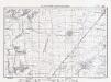
Lambert-Cholesky sheet 2072 (Leş)
1 : 20000 Romanian military topographic map sheet under Lambert-Cholensky projection Direcția Topografică Militară geo-spatial.org Direcția Topografică Militară
Lambert-Cholesky sheet 2075 (Pocsaj)
1 : 20000 Romanian military topographic map sheet under Lambert-Cholensky projection Institutul Geografic Militar geo-spatial.org Institutul Geografic Militar
Nagy-Szalonta.
from Spezialkarte der osterreichisch-ungarischen Monarchie.
Hajdu-Szoboszlo und Esztar.
from Spezialkarte der osterreichisch-ungarischen Monarchie.
N.-Bajom und Szeghalom (Ungarn).
from Spezialkarte der osterreichisch-ungarischen Monarchie.
Nagy-Szalonta
1 : 75000 Salonta, Judeţ Bihor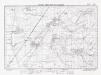
Lambert-Cholesky sheet 2071 (Cefa)
1 : 20000 Romanian military topographic map sheet under Lambert-Cholensky projection Direcția Topografică Militară geo-spatial.org Direcția Topografică Militară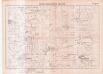
Lambert-Cholesky sheet 1971 (Mezeghian )
1 : 20000 Romanian military topographic map sheet under Lambert-Cholensky projection Serviciul Geografic al Armatei geo-spatial.org Serviciul Geografic al Armatei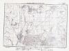
Lambert-Cholesky sheet 2174 (Biharea)
1 : 20000 Romanian military topographic map sheet under Lambert-Cholensky projection Direcția Topografică Militară geo-spatial.org Direcția Topografică Militară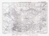
Lambert-Cholesky sheet 2173 (Oradea Nord)
1 : 20000 Romanian military topographic map sheet under Lambert-Cholensky projection Institutul Geografic al Armatei geo-spatial.org Institutul Geografic al Armatei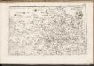
C. Bihariensis. Tab. I
Ungarn Rumänien Komitat Bihar
Süd-Biharer Comitat
1 : 290000 Bihor (Rumunsko)
Süd-Biharer Comitat
1 : 288000 Bihor (Rumunsko : judet)
Süd-Biharer Comitat
1 : 288000 Bihor (Rumunsko)
Das Oesterreichische-Kaiserthum

Debreczen 150, uit: Special-Karte von Mittel-Europa / nach amtlichen Quellen bearbeitet von W. Liebenow
1 : 300000 titelvariant: W. Liebenow's Mittel-Europa; Annotatie: Titel boven de bladen: W. Liebenow's Mittel-Europa Johannes Wilhelm Liebenow 1822-1897 Frankfurt a. M. : Ludwig Ravenstein
A szerbek aránya és száma a Dél-Alföldön 1941-ben
Großes Ungarisches Tiefland (Süd) Serben, Siedlung Bottlik, Zsolt
A szerbek aránya és száma a Dél-Alföldön 1980-ban
Großes Ungarisches Tiefland (Süd) Serben, Siedlung Bottlik, Zsolt
A szerbek aránya és száma a Dél-Alföldön 1880-ban
Großes Ungarisches Tiefland (Süd) Serben, Siedlung Bottlik, Zsolt
Serben in der Südlichen Tiefebene 1880
Großes Ungarisches Tiefland (Süd) Serben, Siedlung Bottlik, Zsolt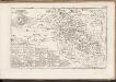
C. Bihariensis. Tab. II
Ungarn Rumänien Komitat Bihar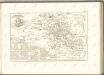

Serben in der Südlichen Tiefebene 1941
Großes Ungarisches Tiefland (Süd) Serben, Siedlung Bottlik, Zsolt
Csaba 164, uit: Special-Karte von Mittel-Europa / nach amtlichen Quellen bearbeitet von W. Liebenow
1 : 300000 titelvariant: W. Liebenow's Mittel-Europa; Annotatie: Titel boven de bladen: W. Liebenow's Mittel-Europa Johannes Wilhelm Liebenow 1822-1897 Frankfurt a. M. : Ludwig Ravenstein