Maps of Mecklenburgische Seenplatte

Anklam 35, uit: Special-Karte von Mittel-Europa / nach amtlichen Quellen bearbeitet von W. Liebenow
1 : 300000 titelvariant: W. Liebenow's Mittel-Europa; Annotatie: Titel boven de bladen: W. Liebenow's Mittel-Europa Johannes Wilhelm Liebenow 1822-1897 Frankfurt a. M. : Ludwig Ravenstein
Theatrum belli in Pomerania citeriori
1 : 225000 Mollova mapová sbírka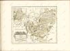

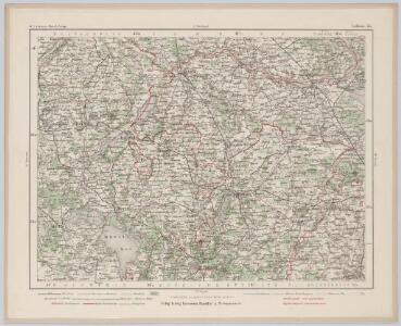
43. Neubrandenburg, uit: Topographische Uebersichtskarte des Deutschen Reiches / herausgegeben v. d. Kartogr. Abt. d. Königl. Preuß. Landesaufnahme
1 : 200000 titelvariant: Topogr. Übersichtskarte des Deutschen Reiches; Annotatie: Titel boven bladen ook: Topogr. Übersichtskarte des Deutschen Reiches; Annotatie geografische gegevens: Op elk blad twee maatstokken: 10 Kilometer = 5,5 cm; 1 geogr. Meile = 3,6 cm; Legenda onder op elk blad Königlich Preußische Landesaufnahme. Kartographische Abtheilung [S.l : Königlich Preußische Landesaufnahme, Kartographische Abtheilung]
Theatrum belli in Pomerania Citeriori
1 : 140000 Mollova mapová sbírka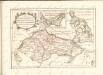

44. Swinemünde, uit: Topographische Uebersichtskarte des Deutschen Reiches / herausgegeben v. d. Kartogr. Abt. d. Königl. Preuß. Landesaufnahme
1 : 200000 titelvariant: Topogr. Übersichtskarte des Deutschen Reiches; Annotatie: Titel boven bladen ook: Topogr. Übersichtskarte des Deutschen Reiches; Annotatie geografische gegevens: Op elk blad twee maatstokken: 10 Kilometer = 5,5 cm; 1 geogr. Meile = 3,6 cm; Legenda onder op elk blad Königlich Preußische Landesaufnahme. Kartographische Abtheilung [S.l : Königlich Preußische Landesaufnahme, Kartographische Abtheilung]
Composite: 120. Anklam. (Germany)
1 : 100000 Reichsamt fur Landesaufnahme
151. Malchin. (Germany)
1 : 100000 Reichsamt fur Landesaufnahme
118. Teterow. (Germany)
1 : 100000 Reichsamt fur Landesaufnahme
Composite: 151. Malchin. (Germany)
1 : 100000 Reichsamt fur Landesaufnahme
120. Anklam. (Germany)
1 : 100000 Reichsamt fur Landesaufnahme
Composite: 118. Teterow. (Germany)
1 : 100000 Reichsamt fur Landesaufnahme
Composite: 152. Neubrandenburg. (Germany)
1 : 100000 Reichsamt fur Landesaufnahme
152. Neubrandenburg. (Germany)
1 : 100000 Reichsamt fur Landesaufnahme
119. Demmin. (Germany)
1 : 100000 Reichsamt fur Landesaufnahme
Composite: 119. Demmin. (Germany)
1 : 100000 Reichsamt fur Landesaufnahme
Composite: 184. Neu-Strelitz. (Germany)
1 : 100000 Reichsamt fur Landesaufnahme
Composite: 185. Woldegk. (Germany)
1 : 100000 Reichsamt fur Landesaufnahme
184. Neu-Strelitz. (Germany)
1 : 100000 Reichsamt fur Landesaufnahme
Composite: 183. Malchow. (Germany)
1 : 100000 Reichsamt fur Landesaufnahme
183. Malchow. (Germany)
1 : 100000 Reichsamt fur Landesaufnahme
Germany 1:25 000, Penzlin
Sheet 1048 from the map series: 1:25,000. Topographische karte (Messtischblätter). Germany. Reichsamt für Landesaufnahme. Berlin : Reichsamt für Landesaufnahme
Germany 1:25 000, Schwinkendorf
Sheet 853 from the map series: 1:25,000. Topographische karte (Messtischblätter). Germany. Reichsamt für Landesaufnahme. Berlin : Reichsamt für Landesaufnahme
Meßtischblatt 2648 : Dedelow, 1919
1 : 250000 Dedelow. - Hrsg. 1883, letzte Nachtr. 1919. - 1:25000. - [Berlin]: Reichsamt für Landesaufnahme, 1919. - 1 Kt.
Meßtischblatt 2647 : Fürstenwerder, 1932
1 : 250000 Fürstenwerder. - Hrsg. 1884, letzte Nachtr. 1932. - 1:25000. - [Berlin]: Reichsamt für Landesaufnahme, 1932. - 1 Kt.
Meßtischblatt 2646 : Feldberg, 1937
1 : 250000 Feldberg. - Hrsg. 1884, einz. Nachtr. 1932, gedr. [19]37. - 1:25000. - [Berlin]: Reichsamt für Landesaufnahme, 1937. - 1 Kt.
Meßtischblatt 2645 : Thurow in Mecklenburg, 1953
1 : 250000 Thurow in Mecklenburg. - Hrsg. 1884, letzte Nachtr. 1932. - 1:25000. - [S.l.]: MdI., 1953. - 1 Kt.
Meßtischblatt 2644 : Neustrelitz, 1932
1 : 250000 Neustrelitz. - Hrsg. 1883, letzte Nachtr. 1932. - 1:25000. - [Berlin]: Reichsamt für Landesaufnahme, 1932. - 1 Kt.