Maps of Anklam-Land

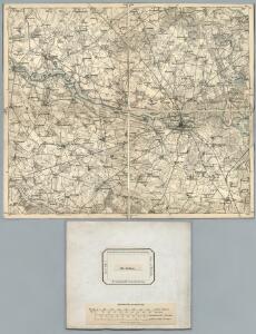
120. Anklam. (Germany)
1 : 100000 Reichsamt fur Landesaufnahme
Composite: 120. Anklam. (Germany)
1 : 100000 Reichsamt fur Landesaufnahme
Meßtischblatt 765 : Anklam, 1885
1 : 250000 Anklam. - Aufn. 1884. - 1:25000. - [Berlin]: Reichsamt für Landesaufnahme, 1885. - 1 Kt.
Meßtischblatt 764 : Medow, 1937
1 : 250000 Medow. - Hrsg. 1885, einz. Nachtr. 1932. - 1:25000. - [Berlin]: Reichsamt für Landesaufnahme, 1937. - 1 Kt.
Meßtischblatt 2047 : Züssow, 1935
1 : 250000 Züssow. - Hrsg. 1886, letzte Nachtr. 1932. - 1:25000. - [Berlin]: Reichsamt für Landesaufnahme, 1935. - 1 Kt.
Meßtischblatt 679 : Rubkow, 1932
1 : 250000 Rubkow. - Hrsg. 1885, einzelne Nachtr. 1932. - 1:25000. - [Berlin]: Reichsamt für Landesaufnahme, 1932. - 1 Kt.
Meßtischblatt 2048 : Rubkow, 1932
1 : 250000 Rubkow. - Hrsg. 1885, einzelne Nachtr. 1932. - 1:25000. - [Berlin]: Reichsamt für Landesaufnahme, 1932. - 1 Kt.
Meßtischblatt 763, neue Nr. 2146 : Krien, 1936
1 : 250000 Krien. - Hrsg. 1886, einz. Nachtr. 1932, gedr. [19]36. - 1:25000. - [Berlin]: Reichsamt für Landesaufnahme, 1936. - 1 Kt.
Meßtischblatt 2046 : Gützkow, 1935
1 : 250000 Gützkow. - Hrsg. 1886, letzte Nachtr. 1932. - 1:25000. - [Berlin]: Reichsamt für Landesaufnahme, 1935. - 1 Kt.
Meßtischblatt 859 : Ducherow, 1932
1 : 250000 Ducherow. - Hrsg. 1885, einz. Nachtr. 1919, gedr. [19]32. - 1:25000. - [Berlin]: Reichsamt für Landesaufnahme, 1932. - 1 Kt.
Meßtischblatt 2247 : Spantekow, 1911
1 : 250000 Spantekow. - Hrsg. 1885, letzte Nachtr. 1911. - 1:25000. - [Berlin]: Reichsamt für Landesaufnahme, 1911. - 1 Kt.
Meßtischblatt 2246 : Siedenbollentin, 1955
1 : 250000 Siedenbollentin. - Hrsg. 1884, letzte Nachtr. 1911. - 1:25000. - [Berlin]: Reichsamt für Landesaufnahme, 1911. - 1 Kt.
44. Swinemünde, uit: Topographische Uebersichtskarte des Deutschen Reiches / herausgegeben v. d. Kartogr. Abt. d. Königl. Preuß. Landesaufnahme
1 : 200000 titelvariant: Topogr. Übersichtskarte des Deutschen Reiches; Annotatie: Titel boven bladen ook: Topogr. Übersichtskarte des Deutschen Reiches; Annotatie geografische gegevens: Op elk blad twee maatstokken: 10 Kilometer = 5,5 cm; 1 geogr. Meile = 3,6 cm; Legenda onder op elk blad Königlich Preußische Landesaufnahme. Kartographische Abtheilung [S.l : Königlich Preußische Landesaufnahme, Kartographische Abtheilung]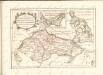

Theatrum belli in Pomerania Citeriori
1 : 140000 Mollova mapová sbírka
Anklam 35, uit: Special-Karte von Mittel-Europa / nach amtlichen Quellen bearbeitet von W. Liebenow
1 : 300000 titelvariant: W. Liebenow's Mittel-Europa; Annotatie: Titel boven de bladen: W. Liebenow's Mittel-Europa Johannes Wilhelm Liebenow 1822-1897 Frankfurt a. M. : Ludwig Ravenstein
Mappa Ducatus Megalopolitani Nova :
1 : 190000 Mollova mapová sbírka
Rugiae, Usedomiae, Et Iulinae, Wandalicarum insularum Vera descriptio
Mollova mapová sbírka Ortelius, Abraham
Theatrum belli in Pomerania citeriori
1 : 225000 Mollova mapová sbírka
Insulae Et Principatus Rugiae cum vicinis Pomeraniae Littoribus Nova Tabula
1 : 210000 Mollova mapová sbírka Homann, Johann Baptista - dědici
Eigentliche Abbildung der Pomerischen Insul Rügen : Auf welcher die Dänen und Allűrte, von den Schweden auß Stralsund unversehens überfallen, eine gäntzliche Niederlag erlitten, und dadurch die ganze Insul den Schweden wieder raumen müssen. Geschehen Dienstag den 8. 18. Januarÿ Anno 1678
1 : 185000 Mollova mapová sbírka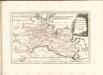

Karte von Neu-Vorpommern und der Insel Rügen
1 : 200000 Přední Pomořansko (Německo) Hagenow, Fr. von Hube, C. A. Fr. v. Hagenow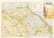
Bäderkarte Usedom

Das Pommerische Kriegs Theatrum
1 : 200000 Mollova mapová sbírka Krügner, Johann Gottfried Boetius, Johann Theodor
Composite: 89. Greifswald. (Germany)
1 : 100000 Reichsamt fur Landesaufnahme
Composite: 121. Swinemunde. (Germany)
1 : 100000 Reichsamt fur Landesaufnahme
121. Swinemunde. (Germany)
1 : 100000 Reichsamt fur Landesaufnahme
89. Greifswald. (Germany)
1 : 100000 Reichsamt fur Landesaufnahme