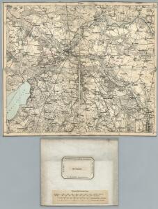
Maps of Demmin-Land

119. Demmin. (Germany)
1 : 100000 Reichsamt fur Landesaufnahme
Composite: 119. Demmin. (Germany)
1 : 100000 Reichsamt fur Landesaufnahme
Meßtischblatt 762, neue Nr. 2145 : Daberkow, 1937
1 : 250000 Daberkow. - Hrsg. 1886, einz. Nachtr. 1932, gedr. [19]37. - 1:25000. - [Berlin]: Reichsamt für Landesaufnahme, 1937. - 1 Kt.
Meßtischblatt 2144 : Leistenow, 1932
1 : 250000 Leistenow. - Hrsg. 1886, einz. Nachtr. 1932. - 1:25000. - [Berlin]: Reichsamt für Landesaufnahme, 1932. - 1 Kt.
Meßtischblatt 760 : Verchen, 1932
1 : 250000 Verchen. - Hrsg. 1885, einz. Nachtr. 1913, gedr. [19]32. - 1:25000. - [Berlin]: Reichsamt für Landesaufnahme, 1932. - 1 Kt.
Meßtischblatt 2045 : Bentzin, 1942
1 : 250000 Bentzin. - Hrsg. 1885, bericht. 1940. - 1:25000. - [Berlin]: Reichsamt für Landesaufnahme, 1942. - 1 Kt.
Meßtischblatt 2044 : Demmin, 1935
1 : 250000 Demmin. - Hrsg. 1885, letzte Nachtr. 1932. - 1:25000. - [Berlin]: Reichsamt für Landesaufnahme, 1935. - 1 Kt.
Meßtischblatt 2043 = [674] : Nossendorf, 1935
1 : 250000 Nossendorf. - Hrsg. 1885, letzte Nachtr. 1932. - 1:25000. - [Berlin]: Reichsamt für Landesaufnahme, [ca. 1935]. - 1 Kt.
Meßtischblatt 590 : Glewitz, 1932
1 : 250000 Glewitz. - Hrsg. 1886, bericht. 1925, einz. Nachtr. 1932. - 1:25000. - [Berlin]: Reichsamt für Landesaufnahme, 1932. - 1 Kt.
Meßtischblatt 590 : Glewitz, 1886
1 : 250000 Glewitz. - Aufn. 1884. - 1:25000. - [Berlin]: Reichsamt für Landesaufnahme, 1886. - 1 Kt.
Meßtischblatt 591 : Gr. Rakow, 1937
1 : 250000 Gr. Rakow. - Hrsg. 1887, bericht. 1920, einz. Nachtr. 1932. - 1:25000. - [Berlin]: Reichsamt für Landesaufnahme, 1937. - 1 Kt.
Meßtischblatt 592, neue Nr. 1945 : Griebenow, 1932
1 : 250000 Griebenow. - Hrsg. 1887, bericht. 1925, einz. Nachtr. 1932. - 1:25000. - [Berlin]: Reichsamt für Landesaufnahme, 1932. - 1 Kt.
Meßtischblatt 592 : Griebenow, 1911
1 : 250000 Griebenow. - Aufn. 1885, hrsg. 1887, einz. Nachtr. 1911. - 1:25000. - [Berlin]: Reichsamt für Landesaufnahme, 1911. - 1 Kt.
Meßtischblatt 592 : Griebenow, 1888
1 : 250000 Griebenow. - Aufn. 1885, hrsg. 1887, einz. Nachtr. 1888. - 1:25000. - [Berlin]: Reichsamt für Landesaufnahme, 1888. - 1 Kt.
43. Neubrandenburg, uit: Topographische Uebersichtskarte des Deutschen Reiches / herausgegeben v. d. Kartogr. Abt. d. Königl. Preuß. Landesaufnahme
1 : 200000 titelvariant: Topogr. Übersichtskarte des Deutschen Reiches; Annotatie: Titel boven bladen ook: Topogr. Übersichtskarte des Deutschen Reiches; Annotatie geografische gegevens: Op elk blad twee maatstokken: 10 Kilometer = 5,5 cm; 1 geogr. Meile = 3,6 cm; Legenda onder op elk blad Königlich Preußische Landesaufnahme. Kartographische Abtheilung [S.l : Königlich Preußische Landesaufnahme, Kartographische Abtheilung]
Meßtischblatt 2245 : Gültz, 1955
1 : 250000 Gültz. - Hrsg. 1886, letzte Nachtr. 1932. - 1:25000. - [Berlin]: Reichsamt für Landesaufnahme, 1932. - 1 Kt.
Meßtischblatt 2244 : Törpin, 1955
1 : 250000 Törpin. - Hrsg. 1885, letzte Nachtr. 1932. - 1:25000. - [Berlin]: Reichsamt für Landesaufnahme, 1932. - 1 Kt.
Meßtischblatt 854 : Ivenack, 1885
1 : 250000 Ivenack. - Aufn. 1884. - 1:25000. - [Berlin]: Reichsamt für Landesaufnahme, 1885. - 1 Kt.
Meßtischblatt 2046 : Gützkow, 1935
1 : 250000 Gützkow. - Hrsg. 1886, letzte Nachtr. 1932. - 1:25000. - [Berlin]: Reichsamt für Landesaufnahme, 1935. - 1 Kt.
Meßtischblatt 763, neue Nr. 2146 : Krien, 1936
1 : 250000 Krien. - Hrsg. 1886, einz. Nachtr. 1932, gedr. [19]36. - 1:25000. - [Berlin]: Reichsamt für Landesaufnahme, 1936. - 1 Kt.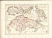

Mappa Ducatus Megalopolitani Nova :
1 : 190000 Mollova mapová sbírka
Theatrum belli in Pomerania Citeriori
1 : 140000 Mollova mapová sbírka
Nieuwe Afteekening van het Eyland Rugen en de Straalsond als mede de Stad Straalsond ent Nieuwe diep met alle desselfs Gelegentheden Int Groot
1 : 170000 Mollova mapová sbírka Keulen, Gerard van Keulen, Gerard van
Eine Accurate Karte Von Pomeren, Wie Auch Dem Landt Rügen, Neben Strahlsundt In Form Seiner Belägerg. : Auch Die Tieffen Des Wasser Mit Sampt Den Grunden
1 : 250000 Mollova mapová sbírka Himmerich, Johann Schenk, Pieter Schenk, Peter II
26. Stralsund, uit: Topographische Uebersichtskarte des Deutschen Reiches / herausgegeben v. d. Kartogr. Abt. d. Königl. Preuß. Landesaufnahme
1 : 200000 titelvariant: Topogr. Übersichtskarte des Deutschen Reiches; Annotatie: Titel boven bladen ook: Topogr. Übersichtskarte des Deutschen Reiches; Annotatie geografische gegevens: Op elk blad twee maatstokken: 10 Kilometer = 5,5 cm; 1 geogr. Meile = 3,6 cm; Legenda onder op elk blad Königlich Preußische Landesaufnahme. Kartographische Abtheilung [S.l : Königlich Preußische Landesaufnahme, Kartographische Abtheilung]
Anklam 35, uit: Special-Karte von Mittel-Europa / nach amtlichen Quellen bearbeitet von W. Liebenow
1 : 300000 titelvariant: W. Liebenow's Mittel-Europa; Annotatie: Titel boven de bladen: W. Liebenow's Mittel-Europa Johannes Wilhelm Liebenow 1822-1897 Frankfurt a. M. : Ludwig Ravenstein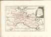

Karte von Neu-Vorpommern und der Insel Rügen
1 : 200000 Přední Pomořansko (Německo) Hagenow, Fr. von Hube, C. A. Fr. v. Hagenow