Maps of Oldenburg-Land

Rostock 22, uit: Special-Karte von Mittel-Europa / nach amtlichen Quellen bearbeitet von W. Liebenow
1 : 300000 titelvariant: W. Liebenow's Mittel-Europa; Annotatie: Titel boven de bladen: W. Liebenow's Mittel-Europa Johannes Wilhelm Liebenow 1822-1897 Frankfurt a. M. : Ludwig Ravenstein
Mappa Ducatus Megalopolitani Nova :
1 : 190000 Mollova mapová sbírka
25. Rostock, uit: Topographische Uebersichtskarte des Deutschen Reiches / herausgegeben v. d. Kartogr. Abt. d. Königl. Preuß. Landesaufnahme
1 : 200000 titelvariant: Topogr. Übersichtskarte des Deutschen Reiches; Annotatie: Titel boven bladen ook: Topogr. Übersichtskarte des Deutschen Reiches; Annotatie geografische gegevens: Op elk blad twee maatstokken: 10 Kilometer = 5,5 cm; 1 geogr. Meile = 3,6 cm; Legenda onder op elk blad Königlich Preußische Landesaufnahme. Kartographische Abtheilung [S.l : Königlich Preußische Landesaufnahme, Kartographische Abtheilung]
24. Eutin, uit: Topographische Uebersichtskarte des Deutschen Reiches / herausgegeben v. d. Kartogr. Abt. d. Königl. Preuß. Landesaufnahme
1 : 200000 titelvariant: Topogr. Übersichtskarte des Deutschen Reiches; Annotatie: Titel boven bladen ook: Topogr. Übersichtskarte des Deutschen Reiches; Annotatie geografische gegevens: Op elk blad twee maatstokken: 10 Kilometer = 5,5 cm; 1 geogr. Meile = 3,6 cm; Legenda onder op elk blad Königlich Preußische Landesaufnahme. Kartographische Abtheilung [S.l : Königlich Preußische Landesaufnahme, Kartographische Abtheilung]
Composite: 60. Oldenburg i/Holst. (Germany)
1 : 100000 Reichsamt fur Landesaufnahme
60. Oldenburg i/Holst. (Germany)
1 : 100000 Reichsamt fur Landesaufnahme
Composite: 40. Wester-Markelsdorf. (Germany)
1 : 100000 Reichsamt fur Landesaufnahme
40. Wester-Markelsdorf. (Germany)
1 : 100000 Reichsamt fur Landesaufnahme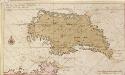
Afteekening vant eijland Femeren geleegen aen de zuijtwal in de Belt
Germany Gerard van Keulen
84. Gromitz. (Germany)
1 : 100000 Reichsamt fur Landesaufnahme
FIMBRIÆ, | Vulgo | FEMEREN | DELINEATIO | GEOMETRICA.
[Amsterdam : Joan Blaeu]
85. Kropelin. (Germany)
1 : 100000 Reichsamt fur Landesaufnahme
Composite: 84. Gromitz. (Germany)
1 : 100000 Reichsamt fur Landesaufnahme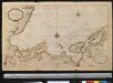
Nieuwe afteekening van een gedeelte van de Belt Zee daer in het in koomen van Wismar en de rivier van Lübeck geleegen aen de kust van Meekelen Burgh
Germany Johannes van Keulen
Composite: 86. Rostock. (Germany)
1 : 100000 Reichsamt fur Landesaufnahme
86. Rostock. (Germany)
1 : 100000 Reichsamt fur Landesaufnahme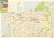
Wanderkarte Rostock und Umgebung

Meßtischblatt 1839 : Bentwisch, 1927
1 : 250000 Bentwisch. - Hrsg. 1879, bericht. 1927. - 1:25000. - [Berlin]: Reichsamt für Landesaufnahme, 1927. - 1 Kt.
Meßtischblatt 507 : Bentwisch, 1892
1 : 250000 Bentwisch. - Aufn. 1877, hrsg. 1879, einz. Nachtr. 1892. - 1:25000. - [Berlin]: Reichsamt für Landesaufnahme, 1892. - 1 Kt.
Meßtischblatt 1838 : Warnemünde, 1936
1 : 250000 Warnemünde. - Hrsg. 1879, bericht. 1927, letzte Nachtr. 1928, gedr. [19]36. - 1:25000. - [Berlin]: Reichsamt für Landesaufnahme, 1936. - 1 Kt.
Meßtischblatt 506 : Warnemünde, 1892
1 : 250000 Warnemünde. - Aufn. 1877, hrsg. 1879, einz. Nachtr. 1892. - 1:25000. - [Berlin]: Reichsamt für Landesaufnahme, 1892. - 1 Kt.
Meßtischblatt 1837 : Bad Doberan, 1927
1 : 250000 Bad Doberan. - Hrsg. 1879, Ausg. 1927. - 1:25000. - [Berlin]: Reichsamt für Landesaufnahme, 1927. - 1 Kt.
Meßtischblatt 505 : Doberan, 1886
1 : 250000 Doberan. - Aufn. 1877, hrsg. 1879, einz. Nachtr. 1886. - 1:25000. - [Berlin]: Reichsamt für Landesaufnahme, 1886. - 1 Kt.
Meßtischblatt 1836 : Kühlungsborn (Ostseebad), 1927
1 : 250000 Kühlungsborn (Ostseebad). - Hrsg. 1897, Ausg. 1927. - 1:25000. - [Berlin]: Reichsamt für Landesaufnahme, 1927. - 1 Kt.
Meßtischblatt 1835 : Rerik, 1939
1 : 250000 Rerik. - Hrsg. 1939. - 1:25000. - [Berlin]: Reichsamt für Landesaufnahme, 1939. - 1 Kt.
Meßtischblatt 503 : Alt- Gaarz, 1879
1 : 250000 Alt- Gaarz. - Aufn. 1877. - 1:25000. - [Berlin]: Reichsamt für Landesaufnahme, 1879. - 1 Kt.
Meßtischblatt502 : Klostersee, 1930
1 : 250000 Klostersee. - Hrsg. 1879, einz. Nachtr. 1930. - 1:25000. - [Berlin]: Reichsamt für Landesaufnahme, 1930. - 1 Kt.
Meßtischblatt 501 : Grömitz, 1889
1 : 250000 Grömitz. - Aufn. 1877, hrsg. 1879, einz. Nachtr. 1889. - 1:25000. - [Berlin]: Reichsamt für Landesaufnahme, 1889. - 1 Kt.
Meßtischblatt 434 : Müritz, 1894
1 : 250000 Müritz. - Aufn. 1877, hrsg. 1879, einz. Nachtr. 1894. - 1:25000. - [Berlin]: Reichsamt für Landesaufnahme, 1894. - 1 Kt.