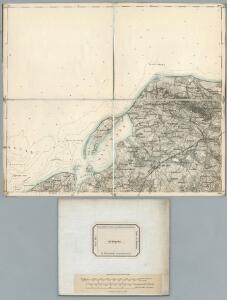
Maps of Neubukow-Salzhaff

85. Kropelin. (Germany)
1 : 100000 Reichsamt fur Landesaufnahme
Composite: 85. Kropelin. (Germany)
1 : 100000 Reichsamt fur Landesaufnahme
Meßtischblatt 1835 : Rerik, 1939
1 : 250000 Rerik. - Hrsg. 1939. - 1:25000. - [Berlin]: Reichsamt für Landesaufnahme, 1939. - 1 Kt.
Meßtischblatt 503 : Alt- Gaarz, 1879
1 : 250000 Alt- Gaarz. - Aufn. 1877. - 1:25000. - [Berlin]: Reichsamt für Landesaufnahme, 1879. - 1 Kt.
Meßtischblatt 1836 : Kühlungsborn (Ostseebad), 1927
1 : 250000 Kühlungsborn (Ostseebad). - Hrsg. 1897, Ausg. 1927. - 1:25000. - [Berlin]: Reichsamt für Landesaufnahme, 1927. - 1 Kt.
Meßtischblatt 582 : Russow, 1927
1 : 250000 Russow. - Hrsg. 1879, bericht. 1927. - 1:25000. - [Berlin]: Reichsamt für Landesaufnahme, 1927. - 1 Kt.
Meßtischblatt 583 : Kröpelin, 1927
1 : 250000 Kröpelin. - Hrsg. 1879, bericht. 1927. - 1:25000. - [Berlin]: Reichsamt für Landesaufnahme, 1927. - 1 Kt.
Meßtischblatt 581 : Kaltenhof (Insel Poel), 1927
1 : 250000 Kaltenhof (Insel Poel). - Hrsg. 1879, bericht. 1927. - 1:25000. - [Berlin]: Reichsamt für Landesaufnahme, 1927. - 1 Kt.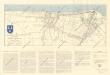
Bädekarte Kühlungsborn und Umgebung

25. Rostock, uit: Topographische Uebersichtskarte des Deutschen Reiches / herausgegeben v. d. Kartogr. Abt. d. Königl. Preuß. Landesaufnahme
1 : 200000 titelvariant: Topogr. Übersichtskarte des Deutschen Reiches; Annotatie: Titel boven bladen ook: Topogr. Übersichtskarte des Deutschen Reiches; Annotatie geografische gegevens: Op elk blad twee maatstokken: 10 Kilometer = 5,5 cm; 1 geogr. Meile = 3,6 cm; Legenda onder op elk blad Königlich Preußische Landesaufnahme. Kartographische Abtheilung [S.l : Königlich Preußische Landesaufnahme, Kartographische Abtheilung]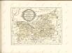

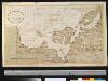
Mappa Ducatus Megalopolitani Nova :
1 : 190000 Mollova mapová sbírka
Rostock 22, uit: Special-Karte von Mittel-Europa / nach amtlichen Quellen bearbeitet von W. Liebenow
1 : 300000 titelvariant: W. Liebenow's Mittel-Europa; Annotatie: Titel boven de bladen: W. Liebenow's Mittel-Europa Johannes Wilhelm Liebenow 1822-1897 Frankfurt a. M. : Ludwig Ravenstein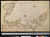
Nieuwe afteekening van een gedeelte van de Belt Zee daer in het in koomen van Wismar en de rivier van Lübeck geleegen aen de kust van Meekelen Burgh
Germany Johannes van Keulen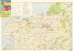
Wanderkarte Rostock und Umgebung
Nieuwe affteekening vande haven en stad Wismar met desselfs inkoomende zee gaten soo beoosten als bewesten Poel Eijland
Germany Gerard van Keulen
Nieuwe Afteekening van de Haven en Stad Wismar met Desselfs Inkoomende zee Gaaten soo Beoosten als Beweste Poel Eyland en beleegering van dito Stad
1 : 65000 Mollova mapová sbírka Keulen, Gerard van Keulen, Gerard van
Particulier-Carte der Gegend Von Wismar nebst Der Insul Pöel und angedeuteter Bloquade zu Wasser und Lande 1715
1 : 45000 Mollova mapová sbírka Varenius, Heinrich Homann, Johann Baptista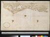
Gedeelte van de kust van Mecklenburg bij Rostock
Germany Gerard van Keulen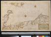
Nieuwe afteekening van een gedeelte van de Belt Zee vervattende de zeekusten van Holsteijn en Mekelenburg van het eijlant Femeren tot aan Mardorp in Pomeren
Germany Johannes van Keulen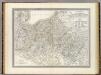
Mecklenburg-Schwerin, Mecklenburg-Strelitz.
1 : 360000 Weiland, C. F. (Carl Ferdinand), d. 1847

Meklenbvrg Dvcatvs
1 : 520000 Mollova mapová sbírka Lauremberg, Johann Schenk, Peter I
Meklenbvrg Dvcatvs
1 : 520000 Mollova mapová sbírka Lauremberg, Johann Janssonius, Johannes I
Meklenbvrg Dvcatvs
1 : 680000 Mollova mapová sbírka Merian, Matthaeus Merian, Matthäus - dědici
Charte von dem Gross-Herzogthümern Mecklenburg-Schwerin, und Mecklenburg-Strelitz
1 : 359000 Meklenbursko (Německo) Streit, Friedrich Wilhelm Friedrich Campe
Das Hertzogthum Mecklenburg in Nieder Sächßischen Creiße Teutschlandes mit seinen abgetheilten Provintzen
1 : 1300000 Mollova mapová sbírka Weigel, Christoph Weigel, Christoph I.
Mecklenburg.
1 : 595000 Flemming, Carl
Ducatus Meklenburgici Tabula Generalis
1 : 470000 Mollova mapová sbírka Homann, Johann Baptist Homann, Johann Baptista