Maps of Bad Doberan-Land

25. Rostock, uit: Topographische Uebersichtskarte des Deutschen Reiches / herausgegeben v. d. Kartogr. Abt. d. Königl. Preuß. Landesaufnahme
1 : 200000 titelvariant: Topogr. Übersichtskarte des Deutschen Reiches; Annotatie: Titel boven bladen ook: Topogr. Übersichtskarte des Deutschen Reiches; Annotatie geografische gegevens: Op elk blad twee maatstokken: 10 Kilometer = 5,5 cm; 1 geogr. Meile = 3,6 cm; Legenda onder op elk blad Königlich Preußische Landesaufnahme. Kartographische Abtheilung [S.l : Königlich Preußische Landesaufnahme, Kartographische Abtheilung]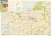
Wanderkarte Rostock und Umgebung

Composite: 86. Rostock. (Germany)
1 : 100000 Reichsamt fur Landesaufnahme
85. Kropelin. (Germany)
1 : 100000 Reichsamt fur Landesaufnahme
Composite: 85. Kropelin. (Germany)
1 : 100000 Reichsamt fur Landesaufnahme
86. Rostock. (Germany)
1 : 100000 Reichsamt fur Landesaufnahme
Meßtischblatt 586 : Petschow, 1930
1 : 250000 Petschow. - Hrsg. 1879, bericht. 1927, einz. Nachtr. 1930. - 1:25000. - [Berlin]: Reichsamt für Landesaufnahme, 1930. - 1 Kt.
Meßtischblatt 586 : Petschow, 1898
1 : 250000 Petschow. - Aufn. 1877, hrsg. 1879, einz. Nachtr. 1898. - 1:25000. - [Berlin]: Reichsamt für Landesaufnahme, 1898. - 1 Kt.
Meßtischblatt 1938 : Rostock, 1937
1 : 250000 Rostock. - Hrsg. 1879, bericht. 1927, gedr. [19]37. - 1:25000. - [Berlin]: Reichsamt für Landesaufnahme, 1937. - 1 Kt.
Meßtischblatt 585 : Rostock, 1898
1 : 250000 Rostock. - Aufn. 1877, hrsg. 1879, einz. Nachtr. 1898. - 1:25000. - [Berlin]: Reichsamt für Landesaufnahme, 1898. - 1 Kt.
Meßtischblatt 584 : Hanstorf, 1888
1 : 250000 Hanstorf. - Aufn. 1877, hrsg. 1879, einz. Nachtr. 1888. - 1:25000. - [Berlin]: Reichsamt für Landesaufnahme, 1888. - 1 Kt.
Meßtischblatt 583 : Kröpelin, 1927
1 : 250000 Kröpelin. - Hrsg. 1879, bericht. 1927. - 1:25000. - [Berlin]: Reichsamt für Landesaufnahme, 1927. - 1 Kt.
Meßtischblatt 582 : Russow, 1927
1 : 250000 Russow. - Hrsg. 1879, bericht. 1927. - 1:25000. - [Berlin]: Reichsamt für Landesaufnahme, 1927. - 1 Kt.
Meßtischblatt 581 : Kaltenhof (Insel Poel), 1927
1 : 250000 Kaltenhof (Insel Poel). - Hrsg. 1879, bericht. 1927. - 1:25000. - [Berlin]: Reichsamt für Landesaufnahme, 1927. - 1 Kt.
Meßtischblatt 1839 : Bentwisch, 1927
1 : 250000 Bentwisch. - Hrsg. 1879, bericht. 1927. - 1:25000. - [Berlin]: Reichsamt für Landesaufnahme, 1927. - 1 Kt.
Meßtischblatt 507 : Bentwisch, 1892
1 : 250000 Bentwisch. - Aufn. 1877, hrsg. 1879, einz. Nachtr. 1892. - 1:25000. - [Berlin]: Reichsamt für Landesaufnahme, 1892. - 1 Kt.
Meßtischblatt 1838 : Warnemünde, 1936
1 : 250000 Warnemünde. - Hrsg. 1879, bericht. 1927, letzte Nachtr. 1928, gedr. [19]36. - 1:25000. - [Berlin]: Reichsamt für Landesaufnahme, 1936. - 1 Kt.
Meßtischblatt 506 : Warnemünde, 1892
1 : 250000 Warnemünde. - Aufn. 1877, hrsg. 1879, einz. Nachtr. 1892. - 1:25000. - [Berlin]: Reichsamt für Landesaufnahme, 1892. - 1 Kt.
Meßtischblatt 1837 : Bad Doberan, 1927
1 : 250000 Bad Doberan. - Hrsg. 1879, Ausg. 1927. - 1:25000. - [Berlin]: Reichsamt für Landesaufnahme, 1927. - 1 Kt.
Meßtischblatt 505 : Doberan, 1886
1 : 250000 Doberan. - Aufn. 1877, hrsg. 1879, einz. Nachtr. 1886. - 1:25000. - [Berlin]: Reichsamt für Landesaufnahme, 1886. - 1 Kt.
Meßtischblatt 1836 : Kühlungsborn (Ostseebad), 1927
1 : 250000 Kühlungsborn (Ostseebad). - Hrsg. 1897, Ausg. 1927. - 1:25000. - [Berlin]: Reichsamt für Landesaufnahme, 1927. - 1 Kt.
Meßtischblatt 1835 : Rerik, 1939
1 : 250000 Rerik. - Hrsg. 1939. - 1:25000. - [Berlin]: Reichsamt für Landesaufnahme, 1939. - 1 Kt.
Meßtischblatt 503 : Alt- Gaarz, 1879
1 : 250000 Alt- Gaarz. - Aufn. 1877. - 1:25000. - [Berlin]: Reichsamt für Landesaufnahme, 1879. - 1 Kt.
Meßtischblatt 434 : Müritz, 1894
1 : 250000 Müritz. - Aufn. 1877, hrsg. 1879, einz. Nachtr. 1894. - 1:25000. - [Berlin]: Reichsamt für Landesaufnahme, 1894. - 1 Kt.
Meßtischblatt 433 : Fischer-Buden, 1879
1 : 250000 Fischer-Buden. - Aufn. 1877. - 1:25000. - [Berlin]: Reichsamt für Landesaufnahme, 1879. - 1 Kt.
Bädekarte Kühlungsborn und Umgebung
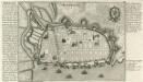
Rostock.
Mollova mapová sbírka Bodenehr, Gabriel Bodenehr, Gabriel
Mappa Ducatus Megalopolitani Nova :
1 : 190000 Mollova mapová sbírka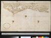
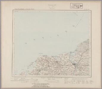
Gedeelte van de kust van Mecklenburg bij Rostock
Germany Gerard van Keulen