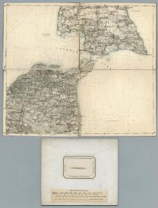
Maps of Oldenburg-Land

60. Oldenburg i/Holst. (Germany)
1 : 100000 Reichsamt fur Landesaufnahme
Composite: 60. Oldenburg i/Holst. (Germany)
1 : 100000 Reichsamt fur Landesaufnahme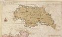
Afteekening vant eijland Femeren geleegen aen de zuijtwal in de Belt
Germany Gerard van Keulen
FIMBRIÆ, | Vulgo | FEMEREN | DELINEATIO | GEOMETRICA.
[Amsterdam : Joan Blaeu]
Meßtischblatt 367, neue Nr. 1632 : Grossenbrode, 1879
1 : 250000 Grossenbrode. - Aufn. 1877, hrsg. 1879. - 1:25000. - [Berlin]: Reichsamt für Landesaufnahme, 1879. - 1 Kt.
Meßtischblatt 366, neue Nr. 1631 : Heiligenhafen, 1879
1 : 250000 Heiligenhafen. - Aufn. 1877, hrsg. 1879. - 1:25000. - [Berlin]: Reichsamt für Landesaufnahme, 1879. - 1 Kt.
Meßtischblatt 308 : Burg (Insel Fehmarn), 1905
1 : 250000 Burg (Insel Fehmarn). - Aufn. 1877, hrsg. 1879, einz. Nachtr. 1905. - 1:25000. - [Berlin]: Reichsamt für Landesaufnahme, 1905. - 1 Kt.
Meßtischblatt 307 : Petersdorf (Insel Fehmarn), 1905
1 : 250000 Petersdorf (Insel Fehmarn). - Aufn. 1877, hrsg. 1879, einz. Nachtr. 1905. - 1:25000. - [Berlin]: Reichsamt für Landesaufnahme, 1905. - 1 Kt.
Meßtischblatt 432 : Grube, 1930
1 : 250000 Grube. - Hrsg. 1879, einz. Nachtr. 1930. - 1:25000. - [Berlin]: Reichsamt für Landesaufnahme, 1930. - 1 Kt.
Meßtischblatt 431 : Oldenburg (in Holstein), 1930
1 : 250000 Oldenburg (in Holstein). - Hrsg. 1879, einz. Nachtr. 1930. - 1:25000. - [Berlin]: Reichsamt für Landesaufnahme, 1930. - 1 Kt.
24. Eutin, uit: Topographische Uebersichtskarte des Deutschen Reiches / herausgegeben v. d. Kartogr. Abt. d. Königl. Preuß. Landesaufnahme
1 : 200000 titelvariant: Topogr. Übersichtskarte des Deutschen Reiches; Annotatie: Titel boven bladen ook: Topogr. Übersichtskarte des Deutschen Reiches; Annotatie geografische gegevens: Op elk blad twee maatstokken: 10 Kilometer = 5,5 cm; 1 geogr. Meile = 3,6 cm; Legenda onder op elk blad Königlich Preußische Landesaufnahme. Kartographische Abtheilung [S.l : Königlich Preußische Landesaufnahme, Kartographische Abtheilung]
84. Gromitz. (Germany)
1 : 100000 Reichsamt fur Landesaufnahme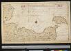
Het Zuijdelijkste gedeelte van de Beld, van de Riv. Sleeswijk tot t eijl. Femeren
Germany Gerard van Keulen
Rostock 22, uit: Special-Karte von Mittel-Europa / nach amtlichen Quellen bearbeitet von W. Liebenow
1 : 300000 titelvariant: W. Liebenow's Mittel-Europa; Annotatie: Titel boven de bladen: W. Liebenow's Mittel-Europa Johannes Wilhelm Liebenow 1822-1897 Frankfurt a. M. : Ludwig Ravenstein
Mappa Ducatus Megalopolitani Nova :
1 : 190000 Mollova mapová sbírka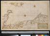
Nieuwe afteekening van een gedeelte van de Belt Zee vervattende de zeekusten van Holsteijn en Mekelenburg van het eijlant Femeren tot aan Mardorp in Pomeren
Germany Johannes van Keulen
WAGRIA, | que est | PARS ORIENTALIS | HOLSATIÆ.
Matthias & Nicolaus Peters | Goltschmide gebr. Hus. sculpst. [Amsterdam : Joan Blaeu]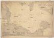
Ostsee
1 : 100000 Dánsko Reichs-Marine-Amt
Wagria, quae est Pars Orientalis Holsatiae. [Karte], in: Novus atlas absolutissimus, Bd. 1, S. 149.
1 Karte aus Atlas Janssonius Offizin
WAGRIÆ | PARS SEPTENTRIONALIS | cum præfectura | CISMAR et OLDENBVRGH.
Christian Lorensen | Rodtgiesser sculps. [Amsterdam : Joan Blaeu]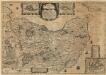
Wagriae Pars Septentrionalis cum praefectura Cismar et Oldenbvrgh
1 : 130000 Mollova mapová sbírka Mejer, Johannes Rothgiesser, Christian Lorenzen Blaeu, Joan I.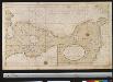
Een gedeelte van de kust van Holsteijn van Kijll of Kielerford tot Femere of New Stadt in de Belt Oost Zee
Germany Gerard van Keulen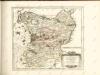

Wagria quae est Pars Orientalis Holsatiae
1 : 190000 Mollova mapová sbírka Janssonius, Johannes Schenk, Peter I
Holsatia ducatus
1 Karte : Kupferdruck ; 33 x 46 cm Mercator; Hondius Henricus Hondius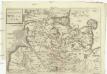
Dvcatvs Holsatiae
Holštýnsko Bouttats, Gaspar
Mecklenburg.
1 : 595000 Flemming, Carl
Holsatia ducatus [Karte], in: Atlas, sive, Cosmographicae meditationes de fabrica mundi et fabricati figura, S. 141.
1 Karte aus Atlas Mercator, Gerhard
Holsatia ducatus [Karte], in: Gerardi Mercatoris Atlas, sive, Cosmographicae meditationes de fabrica mundi et fabricati figura, S. 146.
1 Karte aus Atlas Mercator, Gerhard Montanus, Petrus