Maps of Trelleborgs kommun

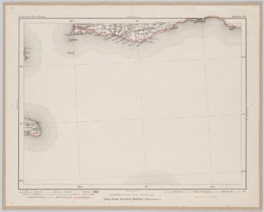
Falsterbo 13, uit: Special-Karte von Mittel-Europa / nach amtlichen Quellen bearbeitet von W. Liebenow
1 : 300000 titelvariant: W. Liebenow's Mittel-Europa; Annotatie: Titel boven de bladen: W. Liebenow's Mittel-Europa Johannes Wilhelm Liebenow 1822-1897 Frankfurt a. M. : Ludwig Ravenstein
26. Stralsund, uit: Topographische Uebersichtskarte des Deutschen Reiches / herausgegeben v. d. Kartogr. Abt. d. Königl. Preuß. Landesaufnahme
1 : 200000 titelvariant: Topogr. Übersichtskarte des Deutschen Reiches; Annotatie: Titel boven bladen ook: Topogr. Übersichtskarte des Deutschen Reiches; Annotatie geografische gegevens: Op elk blad twee maatstokken: 10 Kilometer = 5,5 cm; 1 geogr. Meile = 3,6 cm; Legenda onder op elk blad Königlich Preußische Landesaufnahme. Kartographische Abtheilung [S.l : Königlich Preußische Landesaufnahme, Kartographische Abtheilung]
13. Sagard, uit: Topographische Uebersichtskarte des Deutschen Reiches / herausgegeben v. d. Kartogr. Abt. d. Königl. Preuß. Landesaufnahme
1 : 200000 titelvariant: Topogr. Übersichtskarte des Deutschen Reiches; Annotatie: Titel boven bladen ook: Topogr. Übersichtskarte des Deutschen Reiches; Annotatie geografische gegevens: Op elk blad twee maatstokken: 10 Kilometer = 5,5 cm; 1 geogr. Meile = 3,6 cm; Legenda onder op elk blad Königlich Preußische Landesaufnahme. Kartographische Abtheilung [S.l : Königlich Preußische Landesaufnahme, Kartographische Abtheilung]
12. Wiek a/R., uit: Topographische Uebersichtskarte des Deutschen Reiches / herausgegeben v. d. Kartogr. Abt. d. Königl. Preuß. Landesaufnahme
1 : 200000 titelvariant: Topogr. Übersichtskarte des Deutschen Reiches; Annotatie: Titel boven bladen ook: Topogr. Übersichtskarte des Deutschen Reiches; Annotatie geografische gegevens: Op elk blad twee maatstokken: 10 Kilometer = 5,5 cm; 1 geogr. Meile = 3,6 cm; Legenda onder op elk blad Königlich Preußische Landesaufnahme. Kartographische Abtheilung [S.l : Königlich Preußische Landesaufnahme, Kartographische Abtheilung]
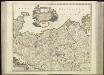
Provinz Pommern
1 : 1650000 Pommern
Provinz Pommern
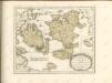
Grosser Hand-Atlas über alle Theile der Erde in 170 Karten Meyer, J. Verlag des Bibliographischen Instituts
Nova Illustrissimi Ducatus Pomeraniae Tabula [Karte], in: Gerardi Mercatoris et I. Hondii Newer Atlas, oder, Grosses Weltbuch, Bd. 1, S. 322.
1 Karte aus Atlas Mercator, Gerhard und Hondius, Jodocus Jansson, Jan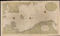
Een gedeelte van de Oost Zee streckende van de Sondt tot aen Dantzigk
Germany Gerard van Keulen
Sect. 2: Stralsund, uit: Geologische Karte des Deutschen Reichs in 27 Blaettern / [von] Richard Lepsius ; Red. von C. Vogel
1 : 500000 Annotatie: Blad 18 ontbreekt; Een aantal bladen op linnen; Een aantal bladen gereviseerd 1913-1914; Annotatie geografische gegevens: Met schaalstokken o.a. in kilometers; Legenda Carl Vogel 1828-1897 Gotha : Justus Perthes
Pomeraniae Ducatus Tabula. [Karte], in: Novus Atlas, das ist, Weltbeschreibung, Bd. 1, S. 90.
1 Karte aus Atlas Blaeu, Joan Blaeu, Willem Janszoon
Pomeraniae Ducatus Tabula. [Karte], in: Theatrum orbis terrarum, sive, Atlas novus, Bd. 1, S. 166.
1 Karte aus Atlas Blaeu, Joan Blaeu, Willem Janszoon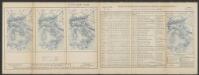
Pomeraniae Ducatus Tabula. [Karte], in: Le théâtre du monde, ou, Nouvel atlas contenant les chartes et descriptions de tous les païs de la terre, Bd. 1, S. 119.
1 Karte aus Atlas Blaeu, Willem Janszoon und Blaeu, Joan Blaeu, Willem Janszoon
POMERANIÆ | DVCATVS TABVLA
Auctore | Eilhardo Lubino. S. Rogiers sculpsit [Amsterdam : Joan Blaeu]
Nova tabula Scaniae, quae est Gothia australis provincias Scaniam, Hallandiam, et Blekingiam complectens
1 : 560000 Švédsko jižní Homann, Johann Baptist J.B. Homann
Provinz Pommern
1 : 938000 Pomořansko (Německo a Polsko) Handtke, Friedrich C. Fleming
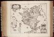
[44][44] Ducatus Meklenburgicus ..., uit: Atlas sive Descriptio terrarum orbis
Annotatie: Gedigitaliseerde versie. Amsterdam. Heiloo : Picturae (vervaardiger), 2015. tiff-bestand. Gedigitaliseerd: 07-01-2015; Origineel: Universiteitsbibliotheek Vrije Universiteit (XL.05127.-) ; Netherlands; Titelpagina ontbreekt Wit, Frederik de Amsterdam : Frederick de Wit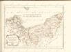
Zeelandia insvla : Danicarum maxima
1 : 390000 Annotatie: Met opdracht van Joan Blaeu aan Petrus Charisius; Origineel is Blad 145 in atlas factice; Annotatie geografische gegevens: Met schaalstok [Amsterdam] : [Joan Blaeu]
Ducatus Mecklenburgici
1 : 480000 Mollova mapová sbírka Seutter, Matthäus Seutter, Matthäus
Selandiae In Regno Daniae Insulae Chorographica Descriptio. [Karte], in: Novus atlas absolutissimus, Bd. 1, S. 125.
1 Karte aus Atlas Janssonius Offizin
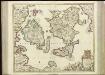
[67][67] Insularum Danicarum ...., uit: Atlas sive Descriptio terrarum orbis
Annotatie: Gedigitaliseerde versie. Amsterdam. Heiloo : Picturae (vervaardiger), 2015. tiff-bestand. Gedigitaliseerd: 07-01-2015; Origineel: Universiteitsbibliotheek Vrije Universiteit (XL.05127.-) ; Netherlands; Titelpagina ontbreekt Wit, Frederik de Amsterdam : Frederick de Wit
ZEELANDIA | INSVLA | Danicarum Maxima.
[Amsterdam : Joan Blaeu]

Nova et accurata Scaniae et maximae partis Zeelandiae tabula
1 : 325000 A Amsterdam : chez Jean Cóvens et Corneille Mortier
Insvlae Danicae in Mari Balthico sitae utpote Zeelandia, Fionia, Langelandia, Lalandia, Falstria, Fembria Mona repraesentatae
1 : 470000 Baltské moře-oblast Homann, Johann Baptist J.B. Homann
Insvlae Danicae in mari Balthico sitae utpote Zeelandia, Fionia, Langelandia, Lalandia, Falstria, Fembria Mona
1 : 470000 Baltské moře-oblast Homann, Johann Baptist a Ioh. Bapt. Homanno