Maps of West-Rügen

12. Wiek a/R., uit: Topographische Uebersichtskarte des Deutschen Reiches / herausgegeben v. d. Kartogr. Abt. d. Königl. Preuß. Landesaufnahme
1 : 200000 titelvariant: Topogr. Übersichtskarte des Deutschen Reiches; Annotatie: Titel boven bladen ook: Topogr. Übersichtskarte des Deutschen Reiches; Annotatie geografische gegevens: Op elk blad twee maatstokken: 10 Kilometer = 5,5 cm; 1 geogr. Meile = 3,6 cm; Legenda onder op elk blad Königlich Preußische Landesaufnahme. Kartographische Abtheilung [S.l : Königlich Preußische Landesaufnahme, Kartographische Abtheilung]
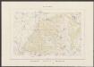
41. Wiek auf Rugen. (Germany)
1 : 100000 Reichsamt fur Landesaufnahme
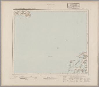
Composite: 41. Wiek auf Rugen. (Germany)
1 : 100000 Reichsamt fur Landesaufnahme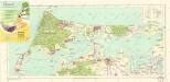
Bäderkarte Prerow Zingst Ahrenshoop Wustrow

Meßtischblatt 1545 : Gingst, 1936
1 : 250000 Gingst. - Hrsg. 1887, bericht. 1925. - 1:25000. - [Berlin]: Reichsamt für Landesaufnahme, 1936. - 1 Kt.
Meßtischblatt 313, neue Nr. 1544 : Klausdorf, 1937
1 : 250000 Klausdorf. - Hrsg. 1886, bericht. 1925. - 1:25000. - [Berlin]: Reichsamt für Landesaufnahme, 1937. - 1 Kt.
Meßtischblatt 1543 : Pramort, 1933
1 : 250000 Pramort. - Hrsg. 1885, bericht. 1925. - 1:25000. - [Berlin]: Reichsamt für Landesaufnahme, 1933. - 1 Kt.
Meßtischblatt 311 : Zingst, 1936
1 : 250000 Zingst. - Hrsg. 1885, bericht. 1924. - 1:25000. - [Berlin]: Reichsamt für Landesaufnahme, 1936. - 1 Kt.
Meßtischblatt 1541 : Prerow, 1932
1 : 250000 Prerow. - Hrsg. 1885, bericht. 1924, letzte Nachtr. 1932. - 1:25000. - [Berlin]: Reichsamt für Landesaufnahme, 1932. - 1 Kt.
Meßtischblatt 309 : Ibenhorst, 1936
1 : 250000 Ibenhorst. - Hrsg. 1885, bericht. 1924. - 1:25000. - [Berlin]: Reichsamt für Landesaufnahme, 1936. - 1 Kt.
Meßtischblatt 258, neue Nr. 1445 : Trent, 1936
1 : 250000 Trent. - Hrsg. 1886, bericht. 1925. - 1:25000. - [Berlin]: Reichsamt für Landesaufnahme, 1936. - 1 Kt.
Meßtischblatt 257, 211 : Kloster, 1914
1 : 250000 Kloster. - Aufn. 1885, hrsg. 1886, Aufldr. 1914. - 1:25000. - [Berlin]: Reichsamt für Landesaufnahme, 1914. - 1 Kt.
Meßtischblatt 212 : Wiek, 1933
1 : 250000 Wiek. - Hrsg. 1886, bericht. 1925. - 1:25000. - [Berlin]: Reichsamt für Landesaufnahme, 1933. - 1 Kt.
Stralsund 23, uit: Special-Karte von Mittel-Europa / nach amtlichen Quellen bearbeitet von W. Liebenow
1 : 300000 titelvariant: W. Liebenow's Mittel-Europa; Annotatie: Titel boven de bladen: W. Liebenow's Mittel-Europa Johannes Wilhelm Liebenow 1822-1897 Frankfurt a. M. : Ludwig Ravenstein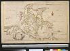
Nieuwe afteekening van het eyland Rügen en de Straat sond als meede de stad Straelsond en't Nieuwe diep alles seer naeukeurig afgeteekent
Germany Johannes van Keulen
Rugia Insula Ac Ducatus accuratissimè descripta ab E. Lubino. [Karte], in: Le théâtre du monde, ou, Nouvel atlas contenant les chartes et descriptions de tous les païs de la terre, Bd. 1, S. 122.
1 Karte aus Atlas Blaeu, Willem Janszoon und Blaeu, Joan Blaeu, Willem Janszoon
Rugia Insula Ac Ducatus accuratissimè descritpta [...] [Karte], in: Theatrum orbis terrarum, sive, Atlas novus, Bd. 1, S. 171.
1 Karte aus Atlas Blaeu, Joan Blaeu, Willem Janszoon
Insulae et principatus Rugiae cum vicinis Pomeraniae littoribus nova tabula
1 : 215000 Pomořansko (Německo a Polsko) Homann, Johann Baptist J. B. Homann
Insulae et principatus Rugiae cum vicinis Pomeraniae littoribus nova tabula
1 : 215000 Pomořansko (Německo a Polsko) Homann, Johann Baptist â Ioh. Baptista Homanno

Rugia Insula Ac Ducatus accuratissimè descripta [Karte], in: Novus Atlas, das ist, Weltbeschreibung, Bd. 1, S. 93.
1 Karte aus Atlas Blaeu, Joan Blaeu, Willem Janszoon

62. Barth. (Germany)
1 : 100000 Reichsamt fur Landesaufnahme
63. Stralsund. (Germany)
1 : 100000 Reichsamt fur Landesaufnahme
Composite: 62. Barth. (Germany)
1 : 100000 Reichsamt fur Landesaufnahme
Composite: 63. Stralsund. (Germany)
1 : 100000 Reichsamt fur Landesaufnahme
Rvgia insvla ac dvcatvs
1 : 270000 Rujana (Německo) Lubin, Eilhard Janssonius, Johannes Ioannis Ianßonius
Rügen