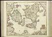
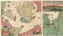
Maps of Sjaælland

[67][67] Insularum Danicarum ...., uit: Atlas sive Descriptio terrarum orbis
Annotatie: Gedigitaliseerde versie. Amsterdam. Heiloo : Picturae (vervaardiger), 2015. tiff-bestand. Gedigitaliseerd: 07-01-2015; Origineel: Universiteitsbibliotheek Vrije Universiteit (XL.05127.-) ; Netherlands; Titelpagina ontbreekt Wit, Frederik de Amsterdam : Frederick de Wit
Nieuwe Pascaert van de Sond ende Beldt :
1 : 470000 Mollova mapová sbírka Keulen, Johannes van Keulen, Johannes van II
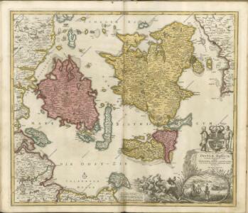
Insvlae Danicae in Mari Balthico sitae utpote Zeelandia, Fionia, Langelandia, Lalandia, Falstria, Fembria Mona repraesentatae
1 : 470000 Baltské moře-oblast Homann, Johann Baptist J.B. Homann
Insvlae Danicae in mari Balthico sitae utpote Zeelandia, Fionia, Langelandia, Lalandia, Falstria, Fembria Mona
1 : 470000 Baltské moře-oblast Homann, Johann Baptist a Ioh. Bapt. Homanno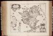
Zeelandia insvla : Danicarum maxima
1 : 390000 Annotatie: Met opdracht van Joan Blaeu aan Petrus Charisius; Origineel is Blad 145 in atlas factice; Annotatie geografische gegevens: Met schaalstok [Amsterdam] : [Joan Blaeu]
Selandiae In Regno Daniae Insulae Chorographica Descriptio. [Karte], in: Novus atlas absolutissimus, Bd. 1, S. 125.
1 Karte aus Atlas Janssonius Offizin
ZEELANDIA | INSVLA | Danicarum Maxima.
[Amsterdam : Joan Blaeu]

Sect. 2: Stralsund, uit: Geologische Karte des Deutschen Reichs in 27 Blaettern / [von] Richard Lepsius ; Red. von C. Vogel
1 : 500000 Annotatie: Blad 18 ontbreekt; Een aantal bladen op linnen; Een aantal bladen gereviseerd 1913-1914; Annotatie geografische gegevens: Met schaalstokken o.a. in kilometers; Legenda Carl Vogel 1828-1897 Gotha : Justus Perthes
Fionia vulgo Funen [Karte], in: Le théâtre du monde, ou, Nouvel atlas contenant les chartes et descriptions de tous les païs de la terre, Bd. 1, S. 52.
1 Karte aus Atlas Blaeu, Willem Janszoon und Blaeu, Joan Blaeu, Willem Janszoon

Nova et Accurata descriptio totius Fioniae vulgo Funen. [Karte], in: Novus atlas absolutissimus, Bd. 1, S. 131.
1 Karte aus Atlas Janssonius Offizin
Fiona vulgo Funen [Karte], in: Theatrum orbis terrarum, sive, Atlas novus, Bd. 1, S. 50.
1 Karte aus Atlas Blaeu, Joan Blaeu, Willem Janszoon
Fionia [Karte], in: Atlas, sive, Cosmographicae meditationes de fabrica mundi et fabricati figura, S. 144.
1 Karte aus Atlas Mercator, Gerhard
Fionia vulgo Funen [Karte], in: Novus Atlas, das ist, Weltbeschreibung, Bd. 1, S. 36.
1 Karte aus Atlas Blaeu, Joan Blaeu, Willem Janszoon

Fionia [Karte], in: Gerardi Mercatoris Atlas, sive, Cosmographicae meditationes de fabrica mundi et fabricati figura, S. 149.
1 Karte aus Atlas Mercator, Gerhard Montanus, Petrus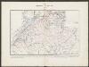
Fionia [Karte], in: Gerardi Mercatoris et I. Hondii Newer Atlas, oder, Grosses Weltbuch, Bd. 1, S. 112.
1 Karte aus Atlas Mercator, Gerhard und Hondius, Jodocus Jansson, Jan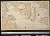
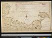
Een gedeelte van de Beldt Zee vertoonende desselfs Westelijkste zeekusten int grood bestek
Denmark Gerard van Keulen
FIONIA | vulgo | FVNEN.
[Amsterdam : Joan Blaeu]
Nationalitäten- und Sprachenkarte des Herzogthums Schleswig
1 : 480000 Jutský poloostrov (Dánsko a Německo) Biernatzki, Hermann Berendsohn, Bernhard S. B.S. Berendsohn
LALANDIA, | FALSTRIA | et | MONA | INSVLÆ | IN MARI BALTHICO.
Joannes Blaeu Excudit.
Lalandiae et Falstriae Accurata Descriptio. [Karte], in: Novus atlas absolutissimus, Bd. 1, S. 128.
1 Karte aus Atlas Janssonius Offizin
Korsör 12, uit: Special-Karte von Mittel-Europa / nach amtlichen Quellen bearbeitet von W. Liebenow
1 : 300000 titelvariant: W. Liebenow's Mittel-Europa; Annotatie: Titel boven de bladen: W. Liebenow's Mittel-Europa Johannes Wilhelm Liebenow 1822-1897 Frankfurt a. M. : Ludwig Ravenstein
Roskilde 3, uit: Special-Karte von Mittel-Europa / nach amtlichen Quellen bearbeitet von W. Liebenow
1 : 300000 titelvariant: W. Liebenow's Mittel-Europa; Annotatie: Titel boven de bladen: W. Liebenow's Mittel-Europa Johannes Wilhelm Liebenow 1822-1897 Frankfurt a. M. : Ludwig Ravenstein
Fionia
1 Karte : Kupferdruck ; 34 x 38 cm Mercator; Hondius Henricus Hondius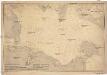
Ostsee
1 : 100000 Dánsko Reichs-Marine-Amt