Maps of Kreis Mettmann

[16] Sect. Düsseldorf, uit: Geologische Karte der Rheinprovinz und der Provinz Westphalen / ausgeführt durch H. von Dechen
1 : 80000 titelvariant: Dechen's geologische Karte vom Rheinland und Westphalen; Annotatie: Titel op bladoverzicht; Incompleet Heinrich von Dechen Berlin : Schropp
109. Düsseldorf, uit: Topographische Uebersichtskarte des Deutschen Reiches / herausgegeben v. d. Kartogr. Abt. d. Königl. Preuß. Landesaufnahme
1 : 200000 titelvariant: Topogr. Übersichtskarte des Deutschen Reiches; Annotatie: Titel boven bladen ook: Topogr. Übersichtskarte des Deutschen Reiches; Annotatie geografische gegevens: Op elk blad twee maatstokken: 10 Kilometer = 5,5 cm; 1 geogr. Meile = 3,6 cm; Legenda onder op elk blad Königlich Preußische Landesaufnahme. Kartographische Abtheilung [S.l : Königlich Preußische Landesaufnahme, Kartographische Abtheilung]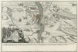
Franzosischer Uberfall der Vestung Rheinfels durch den Marquis de Chartres den 1. Dec. 1758 früh um 5. Uhr
Mollova mapová sbírka Fridrich, Jacob Andreas Fridrich, Jacob Andreas
Le Theatre de Bellone :
Mollova mapová sbírka Schenk, Pieter Braakman, Adriaan
Meßtischblatt 2782 : Remscheid, 1910
1 : 250000 Remscheid. - Aufn. 1893, hrsg. 1895, bericht. 1910. - 1:25000. - [Berlin]: Reichsamt für Landesaufnahme, 1910. - 1 Kt.
Meßtischblatt 2781 : Solingen, 1934
1 : 250000 Solingen. - Hrsg. 1895, bericht. 1927, gedr. [19]34. - 1:25000. - [Berlin]: Reichsamt für Landesaufnahme, 1934. - 1 Kt.
Meßtischblatt 2781 : Solingen, 1910
1 : 250000 Solingen. - Aufn. 1893, hrsg. 1895, bericht. 1910. - 1:25000. - [Berlin]: Reichsamt für Landesaufnahme, 1910. - 1 Kt.
Meßtischblatt 2781 : Hilden, 1910
1 : 250000 Hilden. - Aufn. 1893, hrsg. 1895, bericht. 1909, gedr. [19]10. - 1:25000. - [Berlin]: Reichsamt für Landesaufnahme, 1910. - 1 Kt.
Meßtischblatt 2780 : Hilden, 1895
1 : 250000 Hilden. - Aufn. 1893. - 1:25000. - [Berlin]: Reichsamt für Landesaufnahme, 1895. - 1 Kt.
Meßtischblatt 4806 : Neuß, 1938
1 : 250000 Neuß. - Aufn. 1893, hrsg. 1895, bericht. 1938. - 1:25000. - [Berlin]: Reichsamt für Landesaufnahme, 1938. - 1 Kt.
Meßtischblatt 2721 : Barmen, 1907
1 : 250000 Barmen. - Aufn. 1892, hrsg. 1894, bericht. 1907. - 1:25000. - [Berlin]: Reichsamt für Landesaufnahme, 1907. - 1 Kt.
Meßtischblatt 2720 : Elberfeld, 1927
1 : 250000 Elberfeld. - Aufn. 1892, bericht. 1927. - 1:25000. - [Berlin]: Reichsamt für Landesaufnahme, 1927. - 1 Kt.
Meßtischblatt 2720 : Elberfeld, 1894
1 : 250000 Elberfeld. - Aufn. 1892. - 1:25000. - [Berlin]: Reichsamt für Landesaufnahme, 1894. - 1 Kt.
Meßtischblatt 2719 : Mettmann, 1907
1 : 250000 Mettmann. - Aufn. 1892, hrsg. 1894, bericht. 1907. - 1:25000. - [Berlin]: Reichsamt für Landesaufnahme, 1907. - 1 Kt.
Meßtischblatt 2719 : Mettmann, 1894
1 : 250000 Mettmann. - Aufn. 1892. - 1:25000. - [Berlin]: Reichsamt für Landesaufnahme, 1894. - 1 Kt.
Meßtischblatt 2718 : Düsseldorf, 1936
1 : 250000 Düsseldorf. - Hrsg. 1893, bericht. 1926, einz. Nachtr. 1931, gedr. [19]36. - 1:25000. - [Berlin]: Reichsamt für Landesaufnahme, 1936. - 1 Kt.
37 Uerdingen, uit: De Tranchotkaart van het gebied tussen Maas en Rijn : Nederlands gedeelte
Annotatie: Omslagtitel; Facs. van het Nederlandse deel van de manuscriptkaart van het Rijnland vervaardigd o.l.v. Jean Joseph Tranchot, 1803-1820. - Gereduceerd van 1:20.000 tot 1:25.000 Jean Joseph Tranchot 1752-1815 [Maastricht : Stichting Maaslandse Monografieën]
Meßtischblatt 2845 : Kürten, 1935
1 : 250000 Kürten. - Hrsg. 1896, bericht. 1927, gedr. [19]35. - 1:25000. - [Berlin]: Reichsamt für Landesaufnahme, 1935. - 1 Kt.
Meßtischblatt 2845 : Kürten, 1896
1 : 250000 Kürten. - Aufn. 1893. - 1:25000. - [Berlin]: Reichsamt für Landesaufnahme, 1896. - 1 Kt.
Meßtischblatt Burscheid
1 : 250000 Burscheid. - Aufn. 1893, hrsg. 1895, bericht. 1909. - 1:25000. - [Berlin]: Reichsamt für Landesaufnahme, 1909. - 1 Kt.
Meßtischblatt Burscheid
1 : 250000 Burscheid. - Aufn. 1893. - 1:25000. - [Berlin]: Reichsamt für Landesaufnahme, 1895. - 1 Kt.
Meßtischblatt 2843 : Hitdorf, 1909
1 : 250000 Hitdorf. - Aufn. 1893, hrsg. 1895, bericht. 1909. - 1:25000. - [Berlin]: Reichsamt für Landesaufnahme, 1909. - 1 Kt.
Meßtischblatt 4906 : Stommeln, 1931
1 : 250000 Stommeln. - Hrsg. 1895, bericht. 1926, gedr. [19]31. - 1:25000. - [Berlin]: Reichsamt für Landesaufnahme, 1931. - 1 Kt.
Meßtischblatt 2842 : Stommeln, 1895
1 : 250000 Stommeln. - Aufn. 1893. - 1:25000. - [Berlin]: Reichsamt für Landesaufnahme, 1895. - 1 Kt.
Germany [Town plans of], Dusseldorf
Town plans of Germany, GSGS 4480. Great Britain. War Office. [London] : War Office
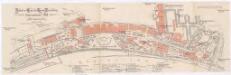
Stadtplan von Düsseldorf
Schwann
Stadtplan von Düsseldorf
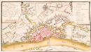
Plan der Stadt und Vestung Düsseldorf wie solche von denen Hannoveranern vom 28te[n] Juny bis den 7 Julii 1758 heftig beschossen und dadurch zur Ubergabe gezwungen worden
Industrie-Gewerbe & Kunst Ausstellung
1 : 3480 Düsseldorf (Německo) Quack & Fischer
![[16] Sect. Düsseldorf, uit: Geologische Karte der Rheinprovinz und der Provinz Westphalen / ausgeführt durch H. von Dechen](https://images-2.georeferencer.com/images/iiif/663107841158/full/,300/0/native.jpg)

