Maps of Kürten

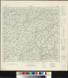
Meßtischblatt 2845 : Kürten, 1935
1 : 250000 Kürten. - Hrsg. 1896, bericht. 1927, gedr. [19]35. - 1:25000. - [Berlin]: Reichsamt für Landesaufnahme, 1935. - 1 Kt.
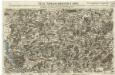
Meßtischblatt 2845 : Kürten, 1896
1 : 250000 Kürten. - Aufn. 1893. - 1:25000. - [Berlin]: Reichsamt für Landesaufnahme, 1896. - 1 Kt.
109. Düsseldorf, uit: Topographische Uebersichtskarte des Deutschen Reiches / herausgegeben v. d. Kartogr. Abt. d. Königl. Preuß. Landesaufnahme
1 : 200000 titelvariant: Topogr. Übersichtskarte des Deutschen Reiches; Annotatie: Titel boven bladen ook: Topogr. Übersichtskarte des Deutschen Reiches; Annotatie geografische gegevens: Op elk blad twee maatstokken: 10 Kilometer = 5,5 cm; 1 geogr. Meile = 3,6 cm; Legenda onder op elk blad Königlich Preußische Landesaufnahme. Kartographische Abtheilung [S.l : Königlich Preußische Landesaufnahme, Kartographische Abtheilung]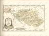
Neue Topographische Carte Der Sieg und Agger von ihrem Ursprunge bis zu ihrem Einflus in den Rhein mit Bemerkung der in dieser Gegend vorgefallenen Kriegsbegebenheiten von 1795 und 1796
Brand, Peter; Schalck, Anna Maria; Coentgen, Georg Joseph Brand
84. North Rhine-Westphalia. The World Atlas.
1 : 250000 USSR (Union of Soviet Socialist Republics).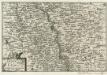
Bonn und Cöln.
1 : 300000 Mollova mapová sbírka Person, Nikolaus Person, Nicolas
Coloniensis archiepiscopatus
1 : 350000 Kolín nad Rýnem-oblast (Německo) Hondius, Henricus apud Henricum Hondium
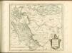
Le Duché de Berg, le Comté de Homberg, les Seugneries de Hardenberg, et de Wildenborg
1 : 230000 Mollova mapová sbírka Sanson, Guillaume Covens, Johannes I
Le Duché de Berg, le Comté de Homberg, les Seugneries de Hardenberg, et de Wildenborg
1 : 230000 Mollova mapová sbírka Sanson, Guillaume Jaillot, Alexis Hubert
Archiepiscopatus Coloniensis Pars Septentrionalis
1 : 260000 Mollova mapová sbírka Gigas, Johann Michael
Archiepiscopatus Coloniensis Pars Septentrionalis
1 : 260000 Mollova mapová sbírka Gigas, Johann Michael
Archiepiscopatus Coloniensis Pars Australis
1 : 260000 Mollova mapová sbírka Gigas, Johann Michael
Archiepiscopatus Coloniensis Pars Australis
1 : 260000 Mollova mapová sbírka Gigas, Johann Michael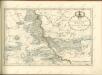

Cöln 84, uit: [W. Liebenow's Special-Karte von Mittel-Europa]
1 : 300000 titelvariant: W. Liebenow's Mittel-Europa; Annotatie: Titel boven de bladen: W. Liebenow's Mittel-Europa Johannes Wilhelm Liebenow 1822-1897 Hannover : Hermann Oppermann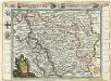
Das Herzogthum Berg hat in die Länge 15 teutsche Meilen und in die dreite 7 =
1 : 690000 Mollova mapová sbírka Baeck, Elias Bäck, Elias
Köln 84, uit: Special-Karte von Mittel-Europa / nach amtlichen Quellen bearbeitet von W. Liebenow
1 : 300000 titelvariant: W. Liebenow's Mittel-Europa; Annotatie: Titel boven de bladen: W. Liebenow's Mittel-Europa Johannes Wilhelm Liebenow 1822-1897 Frankfurt a. M. : Ludwig Ravenstein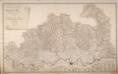
Topographisch-Militairische Karte Des Herzogthums Berg
Wiebeking, Carl Friedrich von; Bechstatt, I. C.
Carte du Comté de la Marck
1 : 160000 Mollova mapová sbírka Le Rouge, Georges-Louis Le Rouge, Georges-Louis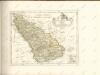

Berge Ducatus Marck Comitatus
1 : 240000 Mollova mapová sbírka Schenk, Pieter Schenk, Peter I
Le Duché De Berg, Le Comté De Homberg, Les Seigneuries De Hardenberg, Et De Wildenborg [Karte], in: Atlas nouveau, contenant toutes les parties du monde [...], Bd. 1, S. 222.
1 Karte aus Atlas Sanson, Nicolas Jaillot, Alexis Hubert und Mortier, Pieter
COMITATVS | MARCHIA | ET | RAVENSBERG
[Amsterdam : Joan Blaeu]
Le Comté De La Marck, Les Seigneuries Des Abbayes De Werden, D'Essen, Et La Ville Imperiale De Dortmundt. [Karte], in: Atlas nouveau, contenant toutes les parties du monde [...], Bd. 1, S. 226.
1 Karte aus Atlas Sanson, Nicolas Jaillot, Alexis Hubert und Mortier, Pieter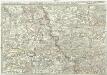
Exactissima totius Vederoviae late sumtae tabula, cujus pars prima est Vederovia stricte sic dicta versus meridiem
1 : 148000 Jülich (Německo) Buna, Wilhelm C.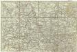
[Exactissima totius Vederoviae late sumtae tabula, cujus pars prima est Vederovia stricte sic dicta versus meridiem]
1 : 148000 Jülich (Německo) Buna, Wilhelm C.
[21] Sec. Siegen, uit: Geologische Karte der Rheinprovinz und der Provinz Westphalen / ausgeführt durch H. von Dechen
1 : 80000 titelvariant: Dechen's geologische Karte vom Rheinland und Westphalen; Annotatie: Titel op bladoverzicht; Incompleet Heinrich von Dechen Berlin : Schropp
Archiepiscopatus et electoratus Coloniensis ut et ducatuum Iuliacensis et Montensis nec non comitatus Meursiae nova tabula
1 : 317000 Kolín nad Rýnem-oblast (Německo) excudente Iohan. Baptista Homanno
Archiepiscopatus et electoratus Coloniensis ut et ducatuum Iuliacensis et Montensis nec non comitatus Meursiae nova tabula
1 : 317000 Kolín nad Rýnem-oblast (Německo) excudente Iohan. Baptista Homanno