Maps of Rhein-Kreis Neuss

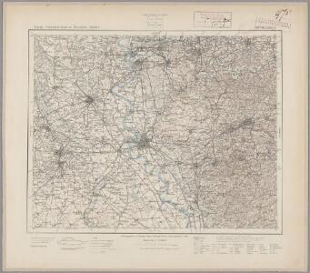
109. Düsseldorf, uit: Topographische Uebersichtskarte des Deutschen Reiches / herausgegeben v. d. Kartogr. Abt. d. Königl. Preuß. Landesaufnahme
1 : 200000 titelvariant: Topogr. Übersichtskarte des Deutschen Reiches; Annotatie: Titel boven bladen ook: Topogr. Übersichtskarte des Deutschen Reiches; Annotatie geografische gegevens: Op elk blad twee maatstokken: 10 Kilometer = 5,5 cm; 1 geogr. Meile = 3,6 cm; Legenda onder op elk blad Königlich Preußische Landesaufnahme. Kartographische Abtheilung [S.l : Königlich Preußische Landesaufnahme, Kartographische Abtheilung]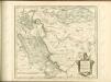

[16] Sect. Düsseldorf, uit: Geologische Karte der Rheinprovinz und der Provinz Westphalen / ausgeführt durch H. von Dechen
1 : 80000 titelvariant: Dechen's geologische Karte vom Rheinland und Westphalen; Annotatie: Titel op bladoverzicht; Incompleet Heinrich von Dechen Berlin : Schropp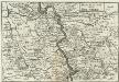
Dusseldorff undt Rheinberg
1 : 280000 Mollova mapová sbírka Person, Nikolaus Person, Nicolas
24me Dusseldorf, uit: Nouvelle carte de la Hollande, d'après Kraijenhoff et les meilleures cartes connues / Établissement Géographique de Bruxelles, fondé par Ph. Vander Maelen
1 : 117000 Annotatie: De bladen zijn genummerd 1-24. De bladen 2 t/m 24 hebben elk een afzonderlijke titel. Blad 5 bevat: Triangulations et positions. Blad 9 bevat: Plan d'Amsterdam; De kaartbladen 1, 5, 9 en 24 zijn niet ingekleurd; Van kaartblad 24 is een extra (ingekleurd) exempl. aanwezig; Annotatie geografische gegevens: 2 schaalstokken: 5 Echelle de 5 lieues de 20 au degré ... (= 23,2 cm) en 7380 Echelle de 5 lieues de 20 au degré ... (= 23,2 cm); Legenda; Met indexkaart: Carte d'assemblage Philippe Marie Guillaume Vander Maelen 1795-1869; Établissement Géographique de Bruxelles Bruxelles : Établissement Géographique
24me Dusseldorf, uit: [Nouvelle carte de la Hollande, d'après Kraijenhoff et les meilleures cartes connus] / [Ph. Vandermaelen]
1 : 130000 Annotatie: Ontbreekt: bl. 1-12 Vandermaelen, Philippe Marie Guillaume Bruxelles : Établissement Géographique
24me Dusseldorf, uit: Nouvelle carte de la Hollande, d'après Kraijenhoff et les meilleures cartes connues / Établissement Géographique de Bruxelles, fondé par Ph. Vander Maelen
1 : 117000 Annotatie: De bladen zijn genummerd 1-24. De bladen 2 t/m 24 hebben elk een afzonderlijke titel. Blad 5 bevat: Triangulations et positions. Blad 9 bevat: Plan d'Amsterdam; De kaartbladen 1, 5, 9 en 24 zijn niet ingekleurd; Van kaartblad 24 is een extra (ingekleurd) exempl. aanwezig; Annotatie geografische gegevens: 2 schaalstokken: 5 Echelle de 5 lieues de 20 au degré ... (= 23,2 cm) en 7380 Echelle de 5 lieues de 20 au degré ... (= 23,2 cm); Legenda; Met indexkaart: Carte d'assemblage Philippe Marie Guillaume Vander Maelen 1795-1869; Établissement Géographique de Bruxelles Bruxelles : Établissement Géographique
Mürs Comitatus [Karte] Mürs Oppidum et Arx. [Nebenkarte] Modiliana. [Nebenkarte], in: Gerardi Mercatoris Atlas, sive, Cosmographicae meditationes de fabrica mundi et fabricati figura, S. 352.
1 Karte aus Atlas Mercator, Gerhard Montanus, Petrus
Plan de la Bataille, gagnée par l'Armée des Alliés, aux Ordres de S. A. S. Mr. le Prince Ferdinand de Brunswic, sur celle de France, commandée par Mr. le Prince de Clermont, près d'Andrad, le 23 Juin 1758
1 : 70000 Mollova mapová sbírka Schley, Jacobus van der Hondt, Pierre de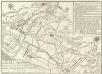
Plan de la Bataille d'Anrad, dans la Plaine de Creeveld
1 : 40000 Mollova mapová sbírka
Bataille De Creveld Ou D'Anrad Entre les Francois et les Hanovriens le 23. Juin 1758
1 : 40000 Le Rouge, Georges-Louis chez le Rouge Ing.r Geogr.e du Roi rue des grands Augustins
Illustrissimo Celsissimoq; Principi Guilielmo Henrico D. G. Arausionum Principi Domino suo Clementissimo Hanc Comitatus Meursensis et Annexarum Dinastiarum Accuratam Tabulam humillime Offert
1 : 80000 Mollova mapová sbírka Heurdt, A. van Wit, Frederick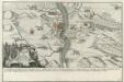
Franzosischer Uberfall der Vestung Rheinfels durch den Marquis de Chartres den 1. Dec. 1758 früh um 5. Uhr
Mollova mapová sbírka Fridrich, Jacob Andreas Fridrich, Jacob Andreas
Bataille de Creveld entre les alliés commandés par le Duc Ferdinand de Brunswic & les français aux ordres du Comte de Clermont le 23 Juin 1758
Therbu, Laurids de; Coentgen, Heinrich Hugo
Meßtischblatt 2845 : Kürten, 1935
1 : 250000 Kürten. - Hrsg. 1896, bericht. 1927, gedr. [19]35. - 1:25000. - [Berlin]: Reichsamt für Landesaufnahme, 1935. - 1 Kt.
Meßtischblatt 2845 : Kürten, 1896
1 : 250000 Kürten. - Aufn. 1893. - 1:25000. - [Berlin]: Reichsamt für Landesaufnahme, 1896. - 1 Kt.
Meßtischblatt Burscheid
1 : 250000 Burscheid. - Aufn. 1893, hrsg. 1895, bericht. 1909. - 1:25000. - [Berlin]: Reichsamt für Landesaufnahme, 1909. - 1 Kt.
Meßtischblatt Burscheid
1 : 250000 Burscheid. - Aufn. 1893. - 1:25000. - [Berlin]: Reichsamt für Landesaufnahme, 1895. - 1 Kt.
Meßtischblatt 2843 : Hitdorf, 1909
1 : 250000 Hitdorf. - Aufn. 1893, hrsg. 1895, bericht. 1909. - 1:25000. - [Berlin]: Reichsamt für Landesaufnahme, 1909. - 1 Kt.
Meßtischblatt 4906 : Stommeln, 1931
1 : 250000 Stommeln. - Hrsg. 1895, bericht. 1926, gedr. [19]31. - 1:25000. - [Berlin]: Reichsamt für Landesaufnahme, 1931. - 1 Kt.
Meßtischblatt 2842 : Stommeln, 1895
1 : 250000 Stommeln. - Aufn. 1893. - 1:25000. - [Berlin]: Reichsamt für Landesaufnahme, 1895. - 1 Kt.
Meßtischblatt 2841 : Grevenbroich, 1895
1 : 250000 Grevenbroich. - Aufn. 1893. - 1:25000. - [Berlin]: Reichsamt für Landesaufnahme, 1895. - 1 Kt.
Meßtischblatt 2840 : Titz, 1895
1 : 250000 Titz. - Aufn. 1893. - 1:25000. - [Berlin]: Reichsamt für Landesaufnahme, 1895. - 1 Kt.
Meßtischblatt 2782 : Remscheid, 1910
1 : 250000 Remscheid. - Aufn. 1893, hrsg. 1895, bericht. 1910. - 1:25000. - [Berlin]: Reichsamt für Landesaufnahme, 1910. - 1 Kt.
Meßtischblatt 2781 : Solingen, 1934
1 : 250000 Solingen. - Hrsg. 1895, bericht. 1927, gedr. [19]34. - 1:25000. - [Berlin]: Reichsamt für Landesaufnahme, 1934. - 1 Kt.
Meßtischblatt 2781 : Solingen, 1910
1 : 250000 Solingen. - Aufn. 1893, hrsg. 1895, bericht. 1910. - 1:25000. - [Berlin]: Reichsamt für Landesaufnahme, 1910. - 1 Kt.
Meßtischblatt 2781 : Hilden, 1910
1 : 250000 Hilden. - Aufn. 1893, hrsg. 1895, bericht. 1909, gedr. [19]10. - 1:25000. - [Berlin]: Reichsamt für Landesaufnahme, 1910. - 1 Kt.
Meßtischblatt 2780 : Hilden, 1895
1 : 250000 Hilden. - Aufn. 1893. - 1:25000. - [Berlin]: Reichsamt für Landesaufnahme, 1895. - 1 Kt.
Meßtischblatt 4806 : Neuß, 1938
1 : 250000 Neuß. - Aufn. 1893, hrsg. 1895, bericht. 1938. - 1:25000. - [Berlin]: Reichsamt für Landesaufnahme, 1938. - 1 Kt.