Maps of Leichlingen

Le Theatre de Bellone :
Mollova mapová sbírka Schenk, Pieter Braakman, Adriaan
Meßtischblatt 2778 : Wevelinghoven, 1896
1 : 250000 Wevelinghoven. - Aufn. 1893. - 1:25000. - [Berlin]: Reichsamt für Landesaufnahme, 1896. - 1 Kt.
Meßtischblatt 4806 : Neuß, 1938
1 : 250000 Neuß. - Aufn. 1893, hrsg. 1895, bericht. 1938. - 1:25000. - [Berlin]: Reichsamt für Landesaufnahme, 1938. - 1 Kt.
Meßtischblatt 2781 : Hilden, 1910
1 : 250000 Hilden. - Aufn. 1893, hrsg. 1895, bericht. 1909, gedr. [19]10. - 1:25000. - [Berlin]: Reichsamt für Landesaufnahme, 1910. - 1 Kt.
Meßtischblatt 2780 : Hilden, 1895
1 : 250000 Hilden. - Aufn. 1893. - 1:25000. - [Berlin]: Reichsamt für Landesaufnahme, 1895. - 1 Kt.
Meßtischblatt 2781 : Solingen, 1934
1 : 250000 Solingen. - Hrsg. 1895, bericht. 1927, gedr. [19]34. - 1:25000. - [Berlin]: Reichsamt für Landesaufnahme, 1934. - 1 Kt.
Meßtischblatt 2781 : Solingen, 1910
1 : 250000 Solingen. - Aufn. 1893, hrsg. 1895, bericht. 1910. - 1:25000. - [Berlin]: Reichsamt für Landesaufnahme, 1910. - 1 Kt.
Meßtischblatt 2782 : Remscheid, 1910
1 : 250000 Remscheid. - Aufn. 1893, hrsg. 1895, bericht. 1910. - 1:25000. - [Berlin]: Reichsamt für Landesaufnahme, 1910. - 1 Kt.
Meßtischblatt 2783 : Wipperfürth, 1910
1 : 250000 Wipperfürth. - Aufn. 1894, hrsg. 1896, einz. Nachtr. 1910. - 1:25000. - [Berlin]: Reichsamt für Landesaufnahme, 1910. - 1 Kt.
[16] Sect. Düsseldorf, uit: Geologische Karte der Rheinprovinz und der Provinz Westphalen / ausgeführt durch H. von Dechen
1 : 80000 titelvariant: Dechen's geologische Karte vom Rheinland und Westphalen; Annotatie: Titel op bladoverzicht; Incompleet Heinrich von Dechen Berlin : Schropp
Descriptio agri civitatis Coloniensis : cum suis limitibus, terminis, viis, confiniis, interjacentibus, et adjacentibus pagis, villis, castris etc
1 : 60000 Cóvens et Mortier apud I. Cóvens et C. Mortier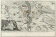
Franzosischer Uberfall der Vestung Rheinfels durch den Marquis de Chartres den 1. Dec. 1758 früh um 5. Uhr
Mollova mapová sbírka Fridrich, Jacob Andreas Fridrich, Jacob Andreas
Meßtischblatt 4804 : M. Gladbach, 1952
1 : 250000 M. Gladbach. - Aufn. 1893, hrsg. 1895, bericht. 1938, letzte Nahtr. 1944. - 1:25000. - [Bonn-Bad Godesberg]: LVA NW, 1952. - 1 Kt.
Meßtischblatt 2784 : Meinerzhagen, 1921
1 : 250000 Meinerzhagen. - Aufn. 1894, Nachtr. 1921. - 1:25000. - [Berlin]: Reichsamt für Landesaufnahme, 1921. - 1 Kt.
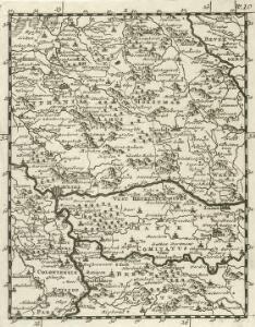
Coloniensis archiepiscopatus
1 : 350000 Kolín nad Rýnem-oblast (Německo) Hondius, Henricus apud Henricum Hondium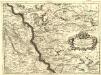
Parte Settentrionale degli Stati dell'Elettore di Colonia
1 : 175000 Mollova mapová sbírka Coronelli, Vincenzo Maria
Archiepiscopatus Coloniensis Pars Septentrionalis
1 : 260000 Mollova mapová sbírka Gigas, Johann Michael
Archiepiscopatus Coloniensis Pars Septentrionalis
1 : 260000 Mollova mapová sbírka Gigas, Johann Michael
Cöln 84, uit: [W. Liebenow's Special-Karte von Mittel-Europa]
1 : 300000 titelvariant: W. Liebenow's Mittel-Europa; Annotatie: Titel boven de bladen: W. Liebenow's Mittel-Europa Johannes Wilhelm Liebenow 1822-1897 Hannover : Hermann Oppermann
Das Herzogthum Berg hat in die Länge 15 teutsche Meilen und in die dreite 7 =
1 : 690000 Mollova mapová sbírka Baeck, Elias Bäck, Elias
Köln 84, uit: Special-Karte von Mittel-Europa / nach amtlichen Quellen bearbeitet von W. Liebenow
1 : 300000 titelvariant: W. Liebenow's Mittel-Europa; Annotatie: Titel boven de bladen: W. Liebenow's Mittel-Europa Johannes Wilhelm Liebenow 1822-1897 Frankfurt a. M. : Ludwig Ravenstein
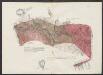
Le Duché De Berg, Le Comté De Homberg, Les Seigneuries De Hardenberg, Et De Wildenborg [Karte], in: Atlas nouveau, contenant toutes les parties du monde [...], Bd. 1, S. 222.
1 Karte aus Atlas Sanson, Nicolas Jaillot, Alexis Hubert und Mortier, Pieter
Comitatus Marchia Et Ravensberg. [Karte] Ravensberg Comitatus. [1 Nebenkarte], in: Theatrum orbis terrarum, sive, Atlas novus, Bd. 1, S. 221.
1 Karte aus Atlas Blaeu, Joan Blaeu, Willem Janszoon

Archevesché et Eslectorat de Cologne avec ses Enclaves dans les Pays Circomvoisins Tiré des Memoires les plus nouveaux
1 : 260000 Mollova mapová sbírka Sanson, Guillaume Jaillot, Alexis Hubert
Archevesché et Eslectorat de Cologne avec ses Enclaves dans les Pays Circomvoisins Tiré des Memoires les plus nouveaux
1 : 260000 Mollova mapová sbírka Sanson, Guillaume Jaillot, Alexis Hubert
Archiepiscopatvs et Electoratvs Coloniensis
1 : 260000 Mollova mapová sbírka Walther, Johann Georg Hailler, Martin Walther, Johann Georg
Comitatus Marchia Et Ravensberg. [Karte] Ravensberg Comitatus. [Nebenkarte], in: Novus atlas absolutissimus, Bd. 2, S. 139.
1 Karte aus Atlas Janssonius Offizin
Comitatus Marchia Et Ravensberg. [Karte] Ravensberg Comitatus. [Nebenkarte], in: Novus Atlas, das ist, Weltbeschreibung, Bd. 1, S. 282.
1 Karte aus Atlas Blaeu, Joan Blaeu, Willem Janszoon