Maps of Pontarlier
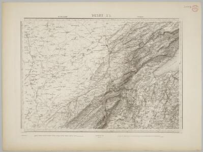
Blatt XI: Pontarlier, Yverdon, uit: Topographische Karte der Schweiz / vermessen und hrsg. ... unter Aufsicht des Generals G.H. Dufour
1 : 100000 Annotatie: Met plaatsnamenregister (bl. V), bladwijzer (bl. XXI) en hoogteregister (bl. XXV); Voor aanwezige bladen zie overzichtsblad Dufour, G. H. [Bern : Eidg. Topogr. Bureau]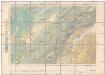
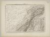
Carte géologique de la Suisse
1 : 100000 Jaccard, A. Bertrand, Marcel
Topographische Karte der Schweiz
1 : 100000 25 Karten vermessen und hrsg. auf Befehl der Eidgenössischen Behörden ; aufgenommen unter der Aufsicht des Generals G.H. Dufour Eidg. Topographisches Bureau, [Genève], [später: Bern]
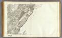
Pontarlier, Yverdon
1 : 100000 1 Karte par Aug. Jaccard [Wurster & Randegger], [Winterthur]
Schlacht bey Granson [i.e. Grandson] am 2. März 1476
1 : 75000 1 Karte Müllhaupt sculps. [Feuerwerker-Gesellschaft], [Zürich]
[Le desséchement de la Plaine de l'Orbe]
1 : 50000 Gonin, Louis Imprimerie Georges Bridel
Lausanne
1 : 100000 [s.n.]
Plan de la bataille de Granson [i.e. Grandson]
1 : 50000 1 Karte composé & dessiné par Frédéric Dubois ; F. Hegi sc. [Antiquarische Gesellschaft], [Zürich]
Lacs de St. Point, de Remoray, des Brenets et de Malpas
1 : 10000 Delebecque, André ; Garcin, E. ; Magnin, J. Ministère des Travaux Publics
Yverdon
1 : 7750 1 Karte Em. de Traytorrens ; D. Herrliberger exc. Herrliberger, Zürich
Principaux lacs du Département du Jura
1 : 10000 Delebecque, André ; Magnin, J. Ministère des Travaux Publics
[Plan de la bataille de Grandson]
1 : 2000 1 Karte Frédéric Dubois del. ; F. Hegi sculps. [Antiquarische Gesellschaft], [Zürich]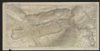
Carte des gorges de l'Areuse
1 : 15000 Borel, Maurice Imprimerie F. Gendre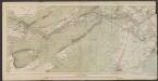
[Gorges de l'Areuse]
1 : 25000 [s.n.]
[Atlas départemental : La France et ses colonies] No. 24 Doubs
1 : 670000 publ. par Michel fils ainé [dressé par A. Lorrain, et gravé par H. Dandeleux] Versailles [etc.] : Barreswil et Andrieux
Vaud
1 : 1450000 [Stumme Kartenskizzen der ganzen Schweiz und der einzelnen Kantone zu Unterrichtszwecken] Schulbuchhandlung Antenen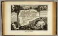
Dept. Du Doubs.
1 : 571000 Levasseur, Victor.

Carte de la Suisse Romande qui comprend le Pays de Vaud et le gouvernement d'Aigle, dépendant du canton de Berne
1 : 90000 Mallet-Prévost, Henri chez F. Monty
Atlas Suisse
1 : 120000 16 Karten levé et dessiné par J.H. Weiss [et Joachim Eugen Müller] aux frais de J.R. Meyer à Aarau dans les années 1786 à 1802 ; gravée [sic] par [Christophe] Guérin, [Matthias Gottfried] Eichler et [Johann Jakob] Scheurmann [Johann Rudolf Meyer], Aarau
Carte de la Suisse romande, 1
1 Blatt : s.n.
Carte du canton de Vaud
1 : 200000 Reber, ... ; Zwahlen, J. Barbey
canton de Vaud
1 : 390000 Keller, Heinrich ; Scheuermann, Johann Jakob Orell Fussli & Comp.
Carte archéologique du Canton de Vaud
1 : 210000 Bonstetten, Gustav Karl <
Le Canton de Vaud - Canton Waadt

Atlas der alten Eidgenossenschaft in 20 Karten: Fürstentum Neuenburg
Originaltitel: Carte de la Souveraineté de Neufchatel et Valangin. Mit Erklärung der Zeichen. Herausgeber: Homännische Erben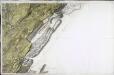
[Nozeroy - les Rousses]
1 Blatt : 59 x 90 cm s.n.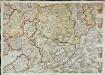
Inclitae Bernatum urbis, cum omni ditionis suae agro et provinciis delineatio chorographica, 11/12
2 Blätter : Adelbert Saueracher
La comté de Neufchatel et partie des cantons de Leman et Fribourg
1 : 108000 Weiss, Johann Heinrich ; Scheuermann, Johann Jakob J. R. Meyer