Maps of District du Jura-Nord vaudois
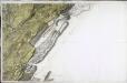
[Nozeroy - les Rousses]
1 Blatt : 59 x 90 cm s.n.
Plus grande partie de la Suisse romande ou canton du Léman
1 : 108000 Weiss, Johann Heinrich ; Guérin, Christophe ; Meyer, Johann Rudolf J. R. Meyer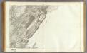
147 Nozeroy, Les Rousses.
1 : 86400 Cassini family; Cassini, Cesar-Francois, 1714-1784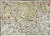
Inclitae Bernatum urbis, cum omni ditionis suae agro et provinciis delineatio chorographica, 11/12
2 Blätter : Adelbert Saueracher
Lausanne
1 : 100000 [s.n.]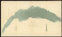
Lac Léman
1 : 50000 Hörnlimann, J. ; Lochmann, Jean Jacques ; Magnin, J. Ministère des Travaux Publics
Carte de la Suisse romande, 3
1 Blatt : s.n.
Topographische Karte des Kantons Freiburg: Blatt 2
1 : 50000 Stryienski, Casimir Napoléon Alexandre (1804-1875), Ingenieur, von Polen Kupferstich: Delsol, Théodore (1819-1870), von Frankreich; Hacq, J. M.; Carré. V.
Carte topographique du canton de Fribourg
1 : 50000 Südwest-Blatt Stryienski, Alexandre ; Delsol, Théodore ; Hacq, J.M. ; Carré, ... F. Chardon ainé
Carte topographique de la grande route de Berne à Genève, Blatt 10-12
3 Blätter : 35 x 48 cm Ochs
Carte topographique de la grande route de Berne à Genève, Blatt 7-9
3 Blätter : 35 x 48 cm Ochs
[Le desséchement de la Plaine de l'Orbe]
1 : 50000 Gonin, Louis Imprimerie Georges Bridel
Carte topographique de la grande route de Berne à Genève, Blatt 13-15
3 Blätter : 35 x 49 cm Ochs
Plan de Lausanne et de sa banlieue
1 : 8000 1 Plan Etabl. topogr. de Wurster, Randegger & Co. F. Payot, Lausanne
[Kaart + gids, p. 4], uit: Plan de Lausanne
1 : 8000 Annotatie: Verso: toeristische informatie; In omslag: straatnamenregister; Annotatie geografische gegevens: Inzet: Panorama du Signal Lausanne : Simplon
Carte de Lausanne et ses environs
1 : 16300 [s.n.]
Plan de la ville de Lausanne et de sa banlieue
1 : 8000 1 Plan Etabl. topogr. de Wurster, Randegger & Co. D. Lebet, éditeur, [Erscheinungsort nicht ermittelbar]
Plan de la ville de Lausanne et de sa banlieue
1 : 5000 Furrer, H. Lebet, D. Lith. H. Furrer
Yverdon
1 : 7750 1 Karte Em. de Traytorrens ; D. Herrliberger exc. Herrliberger, Zürich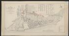
Plan de la ville de Vevey
1 : 2000 Rossier, Vincent ; Wagner, J.F. [s.n.]
Montreux et ses environs
1 : 25000 Aubert, J. ; Krausé, Charles Etabl. lith. et topogr. H. Furrer
Principaux lacs du Département du Jura
1 : 10000 Delebecque, André ; Magnin, J. Ministère des Travaux Publics
Atlas Suisse
1 : 120000 16 Karten levé et dessiné par J.H. Weiss [et Joachim Eugen Müller] aux frais de J.R. Meyer à Aarau dans les années 1786 à 1802 ; gravée [sic] par [Christophe] Guérin, [Matthias Gottfried] Eichler et [Johann Jakob] Scheurmann [Johann Rudolf Meyer], Aarau
Plus grande partie de la Suisse Romande ou République Lémanique.
From Atlas Suisse. Levé et dessiné par J. H. Weiss aux fraix de J. R. Meyer á Aarau dans les années 1786 á 1802. Gravée par Guerin, Eichler, et Scheurmann.
Vaud
1 : 1450000 [Stumme Kartenskizzen der ganzen Schweiz und der einzelnen Kantone zu Unterrichtszwecken] Schulbuchhandlung Antenen
Carte de la Suisse Romande qui comprend le Pays de Vaud et le gouvernement d'Aigle, dépendant du canton de Berne
1 : 90000 Mallet-Prévost, Henri chez F. Monty

Distanzenkarte von der Schweiz
1 : 200000 1 Karte in 8 Teilen nach den besten Hülfsquellen bearb. von R. Huber Wagner, Bern
Das Wiflispurgergow. [Karte], in: Le théâtre du monde, ou, Nouvel atlas contenant les chartes et descriptions de tous les païs de la terre, Bd. 1, S. 282.
1 Karte aus Atlas Blaeu, Willem Janszoon und Blaeu, Joan Blaeu, Willem Janszoon
![[Nozeroy - les Rousses]](http://biblio.unibe.ch/web-apps/maps/zoomify.php?pic=Ryh_2303_30.jpg&col=ryh)

