Maps of Vaud

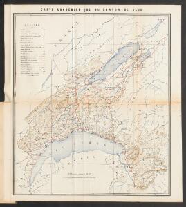
Carte archéologique du Canton de Vaud
1 : 210000 Bonstetten, Gustav Karl <
Carte du canton de Vaud
1 : 200000 Artistische Anstalt F. Malté (Stuttgart) publiée par F. Weber
<<Le>> canton de Vaud
1 : 390000 1 Karte dessiné par H. Keller ; gravé par J.J. Scheurmann Orell Fussli & Comp., Zurich
Carte du canton de Vaud
1 : 200000 Reber, ... ; Zwahlen, J. Barbey
<<Le>> canton de Vaud
1 : 390000 1 Karte dessiné par H. Keller ; gravé par J.J. Scheurmann Orell Fussli & Comp., Zurich

Carte topographique de la grande route de Berne à Genève, 1
2 Blätter : 35 x 42 cm Ochs
Das Wiflispurgergow, ou le territoire d'Avenche
1 Karte : Kupferdruck ; 13 x 17 cm s.n.
Das Wiflispvrgergow
1 Karte : Kupferdruck ; 37 x 48 cm Mercator; Janssonius Joannis Janssonius excud
Das Wiflispvrgergow
1 Karte : Kupferdruck ; 36 x 47 cm Mercator; Schenk; Valck apud G. Valk et P. Schenk
Das Wiflispvrgergow
1 Karte : Kupferdruck ; 37 x 49 cm Blaeu; Mercator Guiljel. Blaeu excudit
<<Le>> canton de Vaud
1 : 390000 1 Karte dessiné par H. Keller ; gravé par J.J. Scheurmann Orell Fussli & Comp., Zurich
<<Le>> canton de Vaud
1 : 390000 1 Karte dessiné par H. Keller ; gravé par J.J. Scheurmann Orell Fussli et Comp., Zurich
<<Le>> canton de Vaud
1 : 390000 1 Karte dessiné par H. Keller ; gravé par J.J. Scheurmann Orell Fussli et Comp., Zurich
canton de Vaud
1 : 390000 Keller, Heinrich ; Scheuermann, Johann Jakob Orell Fussli & Comp.
Atlas de la Suisse
1 : 450000 1 Atlas (19 Bl.) dessiné par MM. H. Keller, Scheurmann, Pfyffer d'Altishofen, Osterwald, etc. ; gravé par M. Scheurmann Orell Füssli & Co., Zürich
Carte de la Suisse Romande qui comprend le Pays de Vaud et le gouvernement d'Aigle, dépendant du canton de Berne
1 : 90000 Mallet-Prévost, Henri chez F. Monty
Atlas der Schweiz
1 : 450000 1 Atlas (18 Bl.) gez. u. gest. v. J. Scheurmann Orell Fussli, Zurich
Le Canton de Vaud - Canton Waadt

Das Wiflispvrgergow
1 : 320000 Mollova mapová sbírka Mercator, Gerhard Schenk, Peter I
Das Wiflispurgergow. [Karte], in: Theatrum orbis terrarum, sive, Atlas novus, Bd. 1, S. 300.
1 Karte aus Atlas Blaeu, Joan Blaeu, Willem Janszoon
Das Wiflispurgergou [Karte], in: Gerardi Mercatoris Atlas, sive, Cosmographicae meditationes de fabrica mundi et fabricati figura, S. 267.
1 Karte aus Atlas Mercator, Gerhard Montanus, Petrus
Das Wiflispurgergow [Karte], in: Novus atlas absolutissimus, Bd. 4, S. 242.
1 Karte aus Atlas Janssonius Offizin
DAS | WIFLISPVR- | GERGOW
Gerardo Mercatore Auctore. Guiljel. Blaeu excudit

Das Wiflispurgergow. [Karte], in: Novus Atlas, das ist, Weltbeschreibung, Bd. 1, S. 251.
1 Karte aus Atlas Blaeu, Joan Blaeu, Willem Janszoon
Vaud
1 : 1450000 [Stumme Kartenskizzen der ganzen Schweiz und der einzelnen Kantone zu Unterrichtszwecken] Schulbuchhandlung Antenen
Das Wiflispvrgergov
1 Karte : Kupferdruck ; 34 x 46 cm Janssonius Joannes Janssonius
Das Wiflispvrgergov
1 Karte : Kupferdruck ; 34 x 46 cm Mercator; Hondius Henricus Hondius