Maps of Vaud

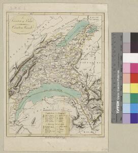
<<Le>> canton de Vaud
1 : 390000 1 Karte dessiné par H. Keller ; gravé par J.J. Scheurmann Orell Fussli et Comp., Zurich
<<Le>> canton de Vaud
1 : 390000 1 Karte dessiné par H. Keller ; gravé par J.J. Scheurmann Orell Fussli et Comp., Zurich
<<Le>> canton de Vaud
1 : 390000 1 Karte dessiné par H. Keller ; gravé par J.J. Scheurmann Orell Fussli & Comp., Zurich
Carte des cantons de Genève, Vaud, Neuchâtel et Fribourg
1 : 250000 1 Karte Topogr. Anstalt von Wurster, Randegger und Co. Wurster, Zürich
<<Le>> canton de Vaud
1 : 390000 1 Karte dessiné par H. Keller ; gravé par J.J. Scheurmann [Orell Fussli et Comp.], [Zurich]
<<Le>> canton de Vaud
1 : 390000 1 Karte dessiné par H. Keller ; gravé par J.J. Scheurmann Orell Fussli & Comp., Zurich
<<Le>> canton de Vaud
1 : 390000 1 Karte dessiné par H. Keller ; gravé par J.J. Scheurmann Orell Fussli & Comp., Zurich
Taschen-Atlas der Schweiz
1 Atlas (25 S., 20 Taf.) gezeichnet und gestochen von Emil Wagner = Atlas de poche de la Suisse : 26 cartes en couleurs / dessinées et gravées par Émile Wagner Eggimann, Genf
<<Das>> Wiflispurgergow
1 : 500000 1 Karte [von Johannes Stumpf] [Christoph Froschauer oder Johann Wolf], [Zürich]
Carte topographique de la grande route de Berne à Genève, 1
2 Blätter : 35 x 42 cm Ochs
Atlas de la Suisse
1 : 450000 1 Atlas (19 Bl.) dessiné par MM. H. Keller, Scheurmann, Pfyffer d'Altishofen, Osterwald, etc. ; gravé par M. Scheurmann Orell Füssli & Co., Zürich
Das Wiflispurgergow, ou le territoire d'Avenche
1 Karte : Kupferdruck ; 13 x 17 cm s.n.
Das Wiflispvrgergow
1 Karte : Kupferdruck ; 37 x 48 cm Mercator; Janssonius Joannis Janssonius excud
Das Wiflispvrgergow
1 Karte : Kupferdruck ; 36 x 47 cm Mercator; Schenk; Valck apud G. Valk et P. Schenk
Das Wiflispvrgergow
1 Karte : Kupferdruck ; 37 x 49 cm Blaeu; Mercator Guiljel. Blaeu excudit
Carte du canton de Vaud
1 : 200000 Artistische Anstalt F. Malté (Stuttgart) publiée par F. Weber
Atlas der Schweiz
1 : 450000 1 Atlas (18 Bl.) gez. u. gest. v. J. Scheurmann Orell Fussli, Zurich
Verbigenus Pagus in Helvetiis Partie du Witlispurgergow en Suisse et dans l'Evesché de Lausanne.
1 : 240000 Mollova mapová sbírka Sanson, Nicolas Somer, Jean Pruthenus Sanson, Nicolas
Das Wiflispurgergow. [Karte], in: Theatrum orbis terrarum, sive, Atlas novus, Bd. 1, S. 300.
1 Karte aus Atlas Blaeu, Joan Blaeu, Willem Janszoon
Das Wiflispvrgergow
1 : 320000 Mollova mapová sbírka Mercator, Gerhard Schenk, Peter I

Das Wiflispurgergow [Karte], in: Novus atlas absolutissimus, Bd. 4, S. 242.
1 Karte aus Atlas Janssonius Offizin
Das Wiflispurgergow. [Karte], in: Novus Atlas, das ist, Weltbeschreibung, Bd. 1, S. 251.
1 Karte aus Atlas Blaeu, Joan Blaeu, Willem Janszoon
Das Wiflispurgergou [Karte], in: Gerardi Mercatoris Atlas, sive, Cosmographicae meditationes de fabrica mundi et fabricati figura, S. 267.
1 Karte aus Atlas Mercator, Gerhard Montanus, Petrus
Carte topographique d'Allemagne contenant les cantons de Bern, et de Freyburg, les principautés de Neufchatel, et Vallangin, le territoire de Genève, et une partie comté de Bourgogne etc
1 : 210000 1 Karte fait par I. W. Iaeger chez l'Auteur., Francfort sur le Mein
DAS | WIFLISPVR- | GERGOW
Gerardo Mercatore Auctore. Guiljel. Blaeu excudit
Vaud
1 : 1450000 [Stumme Kartenskizzen der ganzen Schweiz und der einzelnen Kantone zu Unterrichtszwecken] Schulbuchhandlung Antenen
Das Wiflispurgergou [Karte], in: Gerardi Mercatoris et I. Hondii Newer Atlas, oder, Grosses Weltbuch, Bd. 1, S. 262.
1 Karte aus Atlas Mercator, Gerhard und Hondius, Jodocus Jansson, Jan
Das Wiflispvrgergov
1 Karte : Kupferdruck ; 34 x 46 cm Janssonius Joannes Janssonius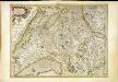
Das Wiflispvrgergov
1 Karte : Kupferdruck ; 34 x 46 cm Mercator; Hondius Henricus Hondius