Maps of District du Val-de-Travers

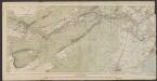
Schlacht bey Granson [i.e. Grandson] am 2. März 1476
1 : 75000 1 Karte Müllhaupt sculps. [Feuerwerker-Gesellschaft], [Zürich]
Plan de la bataille de Granson [i.e. Grandson]
1 : 50000 1 Karte composé & dessiné par Frédéric Dubois ; F. Hegi sc. [Antiquarische Gesellschaft], [Zürich]
[Le desséchement de la Plaine de l'Orbe]
1 : 50000 Gonin, Louis Imprimerie Georges Bridel
Yverdon
1 : 7750 1 Karte Em. de Traytorrens ; D. Herrliberger exc. Herrliberger, Zürich
[Plan de la bataille de Grandson]
1 : 2000 1 Karte Frédéric Dubois del. ; F. Hegi sculps. [Antiquarische Gesellschaft], [Zürich]
Carte de la principauté de Neuchatel
1 : 10000 Neuchâtel (Švýcarsko : kanton) d'Ostervald, J. F. Berthier, Louis Alexandre
Carte de la principauté de Neuchâtel
1 : 95000 Ostervald, Jean-Frédéric d' ; Aubert, J.B.L. Ch. Picquet
Carte de la souveraineté de Neufchatel et Valangin
1 Karte : Kupferdruck ; 40 x 57 cm L'Isle; Merveilleux Homännische Erben
Carte des comtés de Neuchatel et de Vallangin
1 Karte : Kupferdruck ; 31 x 43 cm Clermont; Merveilleux; Perrier; Beauvais; Arrivet Lamy
[Gorges de l'Areuse]
1 : 25000 [s.n.]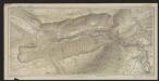
Carte des gorges de l'Areuse
1 : 15000 Borel, Maurice Imprimerie F. Gendre
Carte du canton de Neuchâtel
1 : 100000 1 Karte dessinée et gravée par E. Wagner Delachaux et Niestlé, Neuchâtel
Atlas de la Suisse
1 : 450000 1 Atlas (19 Bl.) dessiné par MM. H. Keller, Scheurmann, Pfyffer d'Altishofen, Osterwald, etc. ; gravé par M. Scheurmann Orell Füssli & Co., Zürich
<<Le>> canton de Neuchâtel
1 : 200000 1 Karte dessiné et gravé d'après la carte de Mr. d'Ostervald par G. Hegi [Orell Füssli], [Zürich]
Carte du canton de Neuchâtel
1 : 150000 1 Karte dressé à l'usage des écoles et des familles par J. Randegger Delachaux et Niestlé, Neuchâtel
Topographische Karte der Schweiz
1 : 100000 25 Karten vermessen und hrsg. auf Befehl der Eidgenössischen Behörden ; aufgenommen unter der Aufsicht des Generals G.H. Dufour Eidg. Topographisches Bureau, [Genève], [später: Bern]
Pontarlier, Yverdon
1 : 100000 1 Karte par Aug. Jaccard [Wurster & Randegger], [Winterthur]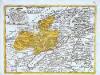
Neufchastel, oder souveraines Fürstenthum Neüenburg in Schweizerischen Bund, nebst der Graffschafft Valangin
1 Karte : Kupferdruck ; 16 x 21 cm Kilian verlegt v. Georg Chr. Kilian
Carte de la Suisse romande, 1
1 Blatt : s.n.
Taschen-Atlas der Schweiz
1 Atlas (25 S., 20 Taf.) gezeichnet und gestochen von Emil Wagner = Atlas de poche de la Suisse : 26 cartes en couleurs / dessinées et gravées par Émile Wagner Eggimann, Genf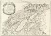
Verbigenus Pagus in Helvetiis
1 : 240000 Mollova mapová sbírka Sanson, Nicolas Somer, Jean Pruthenus Mariette, Pierre
Atlas der alten Eidgenossenschaft in 20 Karten: Fürstentum Neuenburg
Originaltitel: Carte de la Souveraineté de Neufchatel et Valangin. Mit Erklärung der Zeichen. Herausgeber: Homännische Erben
Atlas novus Reipublicae Helveticae
1 Atlas ([40] Bl., 97 S.) bey Orell, Gessner und Compagnie, Zürich

Carte de la souveraineté de Neuchatel et Vallangin
1 Karte : Kupferdruck ; 46 x 63 cm L'Isle; Merveilleux chez Jean Cóvens et Corneille Mortier geographes
Atlas Suisse
1 : 120000 16 Karten levé et dessiné par J.H. Weiss [et Joachim Eugen Müller] aux frais de J.R. Meyer à Aarau dans les années 1786 à 1802 ; gravée [sic] par [Christophe] Guérin, [Matthias Gottfried] Eichler et [Johann Jakob] Scheurmann [Johann Rudolf Meyer], Aarau
Carte du canton de Vaud
1 : 200000 Reber, ... ; Zwahlen, J. Barbey
Atlas de la Suisse
1 : 450000 1 Atlas (19 Bl.) dessiné par MM. H. Keller, Scheurmann, Pfyffer d'Altishofen, Osterwald, etc. ; gravé par M. Scheurmann Orell Füssli & Co., Zürich
![Schlacht bey Granson [i.e. Grandson] am 2. März 1476](https://images-2.georeferencer.com/images/iiif/119582925275/full/,300/0/native.jpg)

