Maps of Vaud


Atlas novus Reipublicae Helveticae
1 Atlas ([40] Bl., 97 S.) bey Orell, Gessner und Compagnie, Zürich
Atlas der alten Eidgenossenschaft in 20 Karten: Kanton Freiburg
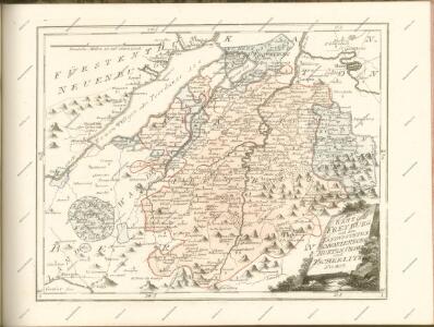
Originaltitel: Canton Freiburg sive Pagus Helvetiae Friburgensis cum confinibus. Mit Erklärung der Zeichen. Zeichnung: Walser, Gabriel (1695-1776), reformierter Pfarrer, von Teufen AR Herausgeber: Homännische Erben
Das Wiflispvrgergov
1 Karte : Kupferdruck ; 34 x 46 cm Janssonius Joannes Janssonius
Das Wiflispvrgergov
1 Karte : Kupferdruck ; 34 x 46 cm Mercator; Hondius Henricus Hondius
Das Wiflispvrgergov
1 Karte : Kupferdruck ; 34 x 45 cm Mercator s.n.
Atlas de la Suisse
1 : 450000 1 Atlas (19 Bl.) dessiné par MM. H. Keller, Scheurmann, Pfyffer d'Altishofen, Osterwald, etc. ; gravé par M. Scheurmann Orell Füssli & Co., Zürich
DAS | WIFLISPVR- | GERGOW
Gerardo Mercatore Auctore. Guiljel. Blaeu excudit
Das Wiflispvrgergow
1 : 320000 Mollova mapová sbírka Mercator, Gerhard Schenk, Peter I
Das Wiflispurgergow, ou le territoire d'Avenche
1 Karte : Kupferdruck ; 13 x 17 cm s.n.
Das Wiflispvrgergow
1 Karte : Kupferdruck ; 37 x 48 cm Mercator; Janssonius Joannis Janssonius excud
Das Wiflispvrgergow
1 Karte : Kupferdruck ; 36 x 47 cm Mercator; Schenk; Valck apud G. Valk et P. Schenk
Das Wiflispvrgergow
1 Karte : Kupferdruck ; 37 x 49 cm Blaeu; Mercator Guiljel. Blaeu excudit

Das Wiflispurgergow. [Karte], in: Novus Atlas, das ist, Weltbeschreibung, Bd. 1, S. 251.
1 Karte aus Atlas Blaeu, Joan Blaeu, Willem Janszoon
Carte topographique de la grande route de Berne à Genève, 1
2 Blätter : 35 x 42 cm Ochs
Das Wiflispurgergow [Karte], in: Novus atlas absolutissimus, Bd. 4, S. 242.
1 Karte aus Atlas Janssonius Offizin
Das Wiflispurgergow. [Karte], in: Theatrum orbis terrarum, sive, Atlas novus, Bd. 1, S. 300.
1 Karte aus Atlas Blaeu, Joan Blaeu, Willem Janszoon
Das Wiflispurgergou [Karte], in: Gerardi Mercatoris et I. Hondii Newer Atlas, oder, Grosses Weltbuch, Bd. 1, S. 262.
1 Karte aus Atlas Mercator, Gerhard und Hondius, Jodocus Jansson, Jan
Das Wiflispurgergow. [Karte], in: Le théâtre du monde, ou, Nouvel atlas contenant les chartes et descriptions de tous les païs de la terre, Bd. 1, S. 282.
1 Karte aus Atlas Blaeu, Willem Janszoon und Blaeu, Joan Blaeu, Willem Janszoon
Taschen-Atlas der Schweiz
1 Atlas (25 S., 20 Taf.) gezeichnet und gestochen von Emil Wagner = Atlas de poche de la Suisse : 26 cartes en couleurs / dessinées et gravées par Émile Wagner Eggimann, Genf
<<Der>> Canton Freyburg
1 : 270000 1 Karte gez. u. gest. von J.J. Scheurmann [Orell Füssli & Comp.], [Zürich]
<<Der>> Canton Freyburg
1 : 270000 1 Karte gez. u. gest. von J.J. Scheurmann [Orell Füssli], [Zürich]
<<Der>> Canton Freyburg
1 : 270000 1 Karte gez. u. gest. von J.J. Scheurmann [Orell Füssli & Comp.], [Zürich]
Carte du canton de Fribourg à l'usage des écoles
1 : 100000 1 Karte dressée en 1851 par Alexandre Stryienski d'après la grande carte topogr. du canton ; gravé par P. Steiner et R. Leuzinger J. Wurster et Comp., Winterthur
<<Der>> Canton Freyburg
1 : 270000 1 Karte gez. u. gest. von J.J. Scheurmann [Orell Füssli], [Zürich]
<<Der>> Canton Freyburg
1 : 270000 1 Karte gez. u. gest. von J.J. Scheurmann [Orell Füssli], [Zürich]
Canton Freiburg sive pagus Helvetiæ Friburgensis cum confinibus
1 Karte : Kupferdruck ; 22 x 26 cm Walser Homännische Erben
Vaud
1 : 1450000 [Stumme Kartenskizzen der ganzen Schweiz und der einzelnen Kantone zu Unterrichtszwecken] Schulbuchhandlung Antenen