Maps of Northwest

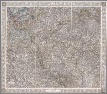
II, uit: General-Karte des oesterreichischen Kaiserstaates mit einem grossen Theile der angrenzenden Länder / durch Josef Scheda ... bearb. und hrsg
1 : 576000 Annotatie geografische gegevens: Maatstokken: oesterreichische Meilen, geografische oder deutsche Meilen, preussische Meilen, türkische Berri, französische Lieues, russische Werste; Maatstok per blad: wiener Klafter, öster. Meilen; Blad XIX: statistische en taalkundige informatie; Blad XIX: legenda [Wien : K.K. Militärisch-Geografisches Institut]
Sheet II: Karte Des Oesterreichischen Kaiserstaates.
1 : 576000 Scheda, Josef
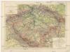
Karte des Königreiches Böhmen
1 : 650000 Česko Raffelsperger, Franz in dem k. k. a. p. Civil-Geograpischen Institut
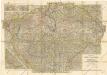
Neueste General-Post & Strassen-Karte des Königreichs Boehmen
1 : 650000 Čechy (Česko) Fried, Franz Artaria
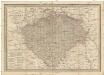
Neueste General-Post & Strassen-Karte des Königreichs Boehmen
1 : 650000 Česko Fried, Franz Artaria & Comp.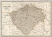
Neueste General-Post & Strassen-Karte des Königreichs Boehmen
1 : 650000 Česko Fried, Franz Artaria & Comp.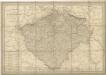
General Post & Strassen Karte des Königreichs Boehmen

Bohemia
General-Post & Strassen-Karte des Königreichs Boehmen
1 : 650000 Čechy (Česko) Fried, Franz Artaria & Comp.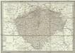
Neueste General-Post & Strassen-Karte des Königreichs Boehmen
1 : 650000 Česko Fried, Franz Artaria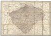
Neueste General-Post & Strassen-Karte des Königreichs Boehmen
Čechy (Česko) Fried, Franz Sartorius, Johann Christoph Artaria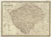
Karte von Böhmen
1 : 660000 Česko Schmitfeldt, Georg Mollo, Tranquillo Tranquillo Mollo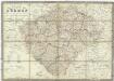
Karte von Böhmen
1 : 660000 Česko Schmitfeldt, Georg Mollo, Tranquillo Tranquillo Mollo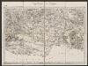
Bohemia [Karte], in: Gerardi Mercatoris Atlas, sive, Cosmographicae meditationes de fabrica mundi et fabricati figura, S. 397.
1 Karte aus Atlas Mercator, Gerhard Montanus, Petrus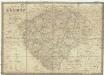
Karte von Böhmen
1 : 660000 Čechy (Česko) Schmitfeldt, Georg Tranquillo Mollo
Přehledná hydrografická mapa povodí Labe, Odry a Dunaje v Čechách
1 : 750000 Dunaj (řeka : povodí) Vojenský zeměpisný ústav
Přehledná hydrografická mapa povodí Labe, Odry a Dunaje v Čechách
1 : 750000 Dunaj (řeka : povodí) Vojenský zeměpisný ústav
Přehledná hydrografická mapa povodí Labe, Odry a Dunaje v Čechách
1 : 750000 Dunaj-povodí Vojenský zeměpisný ústav
Konigreich Boheim, Royaume de Boheme
Mittelbach ́s Neueste Specialkarte von Böhmen

KARTE vom Königreiche Böhmen über sämmtliche Städte, Marktfleke, Flüsse, Poststazionen, Gränz Zollämter u. Kom[m]erzial Strassen
1 : 690000 Česko in der Elsenwangerischen Buchhandlung
Karte vom Königreiche Böhmen über sämmtliche Städte, Marktfleke, Flüsse, Poststazionen, Gränz Zollämter u. Kom[m]erzial Strassen
1 : 693000 Česko in der Elsenwangerischen Buchhandlung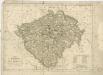
Königreich Böhmen

Bohemia

Charte der älteren und neueren Bergbaue in Böhmen
1 : 960000 Česko Hamernik, J.
Das Königreich Böhmen
Čechy (Česko) Weiland, Karl Ferdinand Jungmann, Carl im Verlage des Geograph. Instituts
Das Königreich Böhmen
Čechy (Česko) Weiland, Karl Ferdinand Jungmann, Carl im Verlage des Geograph. Instituts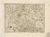
Bohemia

Království česke [sic]
1 : 1500000 Čechy (Česko) Trampler, Richard Filipovský, Karel