Maps of Czech Republic

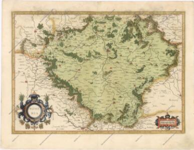
Bohemia
Bohemia [Karte], in: Gerardi Mercatoris Atlas, sive, Cosmographicae meditationes de fabrica mundi et fabricati figura, S. 397.
1 Karte aus Atlas Mercator, Gerhard Montanus, Petrus
General Post & Strassen Karte des Königreichs Boehmen
Nova et accurata Descriptio Geographica Totius Regni Bohemiae...
Neueste General-Post & Strassen-Karte des Königreichs Boehmen
1 : 650000 Česko Fried, Franz Artaria & Comp.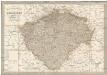
Neueste General-Post & Strassen-Karte des Königreichs Boehmen
1 : 650000 Česko Fried, Franz Artaria & Comp.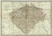
Neueste General-Post & Strassen-Karte des Königreichs Boehmen
1 : 650000 Čechy (Česko) Fried, Franz Artaria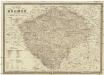
Karte von Böhmen
1 : 660000 Česko Schmitfeldt, Georg Mollo, Tranquillo Tranquillo Mollo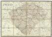
Karte von Böhmen
1 : 660000 Česko Schmitfeldt, Georg Mollo, Tranquillo Tranquillo Mollo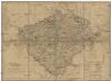
Königreich Böhmen
Česko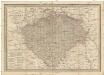
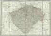
General-Post & Strassen-Karte des Königreichs Boehmen
1 : 650000 Čechy (Česko) Fried, Franz Artaria & Comp.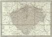
Neueste General-Post & Strassen-Karte des Königreichs Boehmen
1 : 650000 Česko Fried, Franz Artaria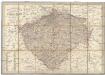
Neueste General-Post & Strassen-Karte des Königreichs Boehmen
Čechy (Česko) Fried, Franz Sartorius, Johann Christoph Artaria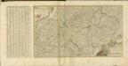

Geologische Übersichtskarte des Österreichischen Monarchie
1 : 576000 Rakousko-Uhersko Hauer, Franz Beck'schen Universitäts Buchhandlung (A. Hölder)
Karte des Königreiches Böhmen
1 : 650000 Česko Raffelsperger, Franz in dem k. k. a. p. Civil-Geograpischen Institut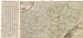
Nova et accurata descriptio geographica totius regni Bohemiae
1 : 731000 Bavorsko (Německo) Lidl, Johann Jakob J.J. Lidl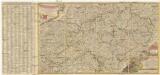
Nova et accurata descriptio geographica totius Regni Bohemiae
1 : 690000 Německo Lidl, Johann Jakob J. J. Lidl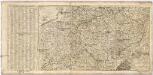
Nova et accurata Descriptio Geographica TOTIUS REGNI BOHEMIAE
1 : 6800000 Německo Lidl, Johann Jakob Joannis Jacobo Lidlii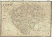
Karte von Böhmen
1 : 660000 Čechy (Česko) Schmitfeldt, Georg Tranquillo Mollo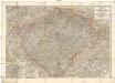
Hölzelova generální mapa Království českého
Čechy (Česko) Wagner, Jan Eduard Lepař, Zdeněk v geografickém závodě Ed. Hölzela
Přehledná hydrografická mapa povodí Labe, Odry a Dunaje v Čechách
1 : 750000 Dunaj (řeka : povodí) Vojenský zeměpisný ústav
Přehledná hydrografická mapa povodí Labe, Odry a Dunaje v Čechách
1 : 750000 Dunaj (řeka : povodí) Vojenský zeměpisný ústav
Přehledná hydrografická mapa povodí Labe, Odry a Dunaje v Čechách
1 : 750000 Dunaj-povodí Vojenský zeměpisný ústav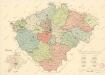
Mapa krajského rozdělení Čech r. 1654 na podkladě územní organisace soudních okresů r. 1946

Bohemia

Království česke [sic]
1 : 1500000 Čechy (Česko) Trampler, Richard Filipovský, Karel
Geognostische Karte des Königsreichs Böhmen
1 : 1020000 Čechy (Česko) Preininger, Andreas Biller, Dominicus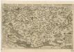
Chogragraphia Insignis Regni Bohemiae