Maps of gmina Zgorzelec

149 Zittau, uit: Topographische Special-Karte von Deutschland (von Central-Europa) / begründet von D.G. Reymann ; [entworfen und gezeichn. von Heinrich Berghaus... [et al.]]
1 : 200000 Annotatie: Lit.: Daniel Gottlob Reymann und die "Topographische Special-Karte von Deutschland" / von Wolfgang Scharfe, in: Kartographische Nachrichten, 39 (1989), Heft I, p. 1-10; Handgeschreven titel: Reymann's Deutschland : 24 Sectionen: Jena, Penig, Dresden, Zittau, Hirschberg, Breslau, Brieg, Andernach, Coblenz, Giessen, Fulda, Schleusingen, Plauen, Zwickau, Teplitz, Jung Bunzlau, Hohenelbe, Glatz, Neisse, Simmern, Prag, Luxemburg, Birkenfeld; Aanwezig: 23 bladen Reymann, Daniel Gottlob; Berghaus, Heinrich [Berlin : 2. Departement des Kriegsministeriums, Bureau für Plan- und Kartenzeichnung]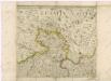
Müllerova mapa Čech
1 : 132000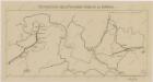
Sbírka map a diagramů použitých na mírových konferencích v Paříži v letech 1919 - 1920

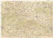
Schluckenau.
from Spezialkarte der osterreichisch-ungarischen Monarchie.
Section Zittau
Das nördlichste Böhmen
1 : 75000 Čechy severní (Česko) Richter, A. Oesfeld, C. W.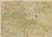
Das nördlichste Böhmen

Schluckenau
1 : 75000 Šluknov (Česko : oblast) Brunner, J. K. u. k. Militärgeographisches Institut
Schluckenau
1 : 75000 Šluknov (Česko : oblast) K. u. k. Militärgeographisches Institut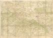
Wanderkarte durch Nordböhmen
Neue Karte von Nordböhmen, der Oberlausitz und der Sächsischen Schweiz
1 : 75000 Horní Lužice (Německo) Heinrich Pfeifer
Šluknov
1 : 75000 Šluknov (Česko : oblast) Vojenský zeměpisný ústav
Šluknov a Bautzen
1 : 75000 Šluknov (Česko : oblast) Vojenský zeměpisný ústav
II. vojenské mapování 1
1 : 144000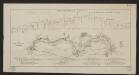
Karte der Löbau-Zittauer Eisenbahn
1 : 57000 Lith. v. F.A. Renner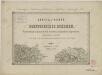
II. vojenské mapování 1
1 : 144000
Soubor přehledných map pro plánování a statistiku: Šluknov 3553

Soubor přehledných map pro plánování a statistiku: 3553 – Šluknov

Generalkarte der Bezirkshauptmannschaft Rumburg
1 : 220000 Rumburk-oblast (Česko) Wagner, Jan Eduard F. Kytka
III. vojenské mapování 3553
1 : 75000
Generální mapa okresních hejtmanství

Rumburg und Warnsdorf.
from Spezialkarte der osterreichisch-ungarischen Monarchie.
Landkreise Schluckenau, Warnsdorf, Rumburg
1 : 75000 Protektorát Čechy a Morava Dienststelle für Raumordnung und Landesplanung beim Regierungspräsidenten
Tschernhausen und Preuss. Corlitz.
from Spezialkarte der osterreichisch-ungarischen Monarchie.
Podrobná mapa Království českého
1 : 100000 Rumburk (Česko : oblast) Srp, Jan Jos. R. Vilímek
Podrobná mapa Království českého
1 : 100000 Frýdlant (Česko : oblast) Srp, Jan Jos. R. Vilímek

Varnsdorf
1 : 75000 Varnsdorf-oblast (Česko) Vojenský zeměpisný ústav
Überfall bei Hochkirch, am 14. Oktober 1758

![149 Zittau, uit: Topographische Special-Karte von Deutschland (von Central-Europa) / begründet von D.G. Reymann ; [entworfen und gezeichn. von Heinrich Berghaus... [et al.]]](https://images-2.georeferencer.com/images/iiif/427743970190/full/,300/0/native.jpg)

