Maps of okres Děčín

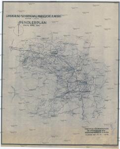
Landkreise Schluckenau, Warnsdorf, Rumburg
1 : 75000 Protektorát Čechy a Morava Dienststelle für Raumordnung und Landesplanung beim Regierungspräsidenten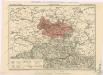
Generální mapa okresních hejtmanství

Soubor přehledných map pro plánování a statistiku: 3553 – Šluknov
Generalkarte der Bezirkshauptmannschaft Schluckenau
1 : 220000 Šluknov-oblast (Česko) Wagner, Jan Eduard F. Kytka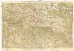
Neue Karte von Nordböhmen, der Oberlausitz und der Sächsischen Schweiz
1 : 75000 Horní Lužice (Německo) Heinrich Pfeifer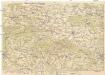
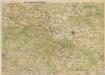
Das nördlichste Böhmen
1 : 75000 Čechy severní (Česko) Richter, A. Oesfeld, C. W.
Děčínsko

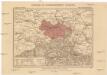
Soubor přehledných map pro plánování a statistiku: Šluknov 3553
Das nördlichste Böhmen

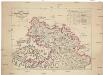
Generalkarte der Bezirkshauptmannschaft Rumburg
1 : 220000 Rumburk-oblast (Česko) Wagner, Jan Eduard F. Kytka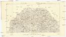
Podrobná mapa Království českého
1 : 100000 Rumburk (Česko : oblast) Srp, Jan Jos. R. Vilímek
Rumburg und Warnsdorf.
from Spezialkarte der osterreichisch-ungarischen Monarchie.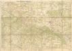
Wanderkarte durch Nordböhmen
Charte des Rumburger Bezirk-Strafgerichtes
1 : 65000 Rumburk-oblast (Česko) Medau, Karel Vilém Lehrpersonale der Leitmeritzer Diöcesan- und Kreis-Hauptschule
Varnsdorf
1 : 75000 Varnsdorf-oblast (Česko) Vojenský zeměpisný ústav
III. vojenské mapování 3653
1 : 75000
Varnsdorf
1 : 75000 Cvikov (Česko : oblast) Vojenský zeměpisný ústav
Rumburg und Warnsdorf
1 : 75000 Rumburk (Česko : oblast) Lampe K. u. k. militär-geographisches Institut
Rumburg und Warnsdorf
1 : 75000 Rumburk (Česko : oblast) Lampe K. u. k. Militärgeographisches Institut
Rumburg und Warnsdorf
1 : 75000 Rumburk (Česko : oblast) K. u. k. Militärgeographisches Institut
Section Stolpen
1 : 56000 Stolpen (Německo) Krylle, K. F. F.T. Hultzsch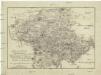
Topographische Reisekarte durch die Meissnischen Aemter Hohenstein und Lohmen und einen Theil der Aemten Pirna und Stolpen oder die sogenannte Sächsische Schweiz
1 : 110000 Míšeň-oblast (Německo) Götzinger, Wilhelm Lebrecht Kreybich, Carl
Česko-sasské Švýcarsko

Sächsisch-Böhmische Schweiz
1 : 50000 Saské Švýcarsko (Německo) C.C. Meinhold & Söhne
Karte des Bezirkes Tetschen
Děčín-oblast (Česko) F. Sandtner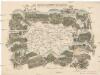
Das böhmisch-sächsische Grenzgebirge
Lužická Nisa-oblast lith. Kunstanstalt von Ed. Strache
Heimatkarte Rumburg - Warnsdorf

Heimatkarte Rumburg - Warnsdorf

Heimatkarte Rumburg - Warnsdorf