Maps of Vouziers
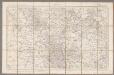
Verdun / [levée] par les officiers du Corps d'Etat-Major
1 : 80000 Corps d'Etat-Major [Paris : Dépôt de la Guerre]
Plans des ville et citadelle de Verdun
1 : 13000
Verdvn
Mollova mapová sbírka Merian, Matthaeus Merian, Matthäus - dědici
Verdvn
Mollova mapová sbírka Merian, Matthaeus Merian, Matthäus - dědici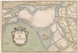
A colored "plan de Verdun
A colored manuscript plan de Verdun, France; "drawn about 1650, on a scale of 95 toises to an inch."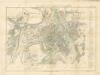
Plan de Verdun
Uerdun.
Mollova mapová sbírka Bodenehr, Gabriel Bodenehr, Gabriel
PLAN ET SIEGE DE DAMVILLERS, | Aßiegeé par Monsr. le Mareschal de CHASTILLON | le I jour de Septembre, MDCXXXVII, | et pris le XXV jour d Octobre suivant
A Amsterdam chez Iean Blaeu
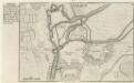
Skizze zum Gefechte bei Voncq am Abend des 29.8.70
1 : 80000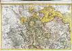
Le Verdunois
1 Karte : Kupferdruck ; 44 x 68 cm Jaillot Alexis Hubert Jaillot
Carte dressee specialement pour les Membres de la Conference...

Reliefkarte des Argonnenwaldes und der Gegend von Verdun
Franckh'sche Verlagshandlung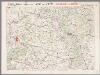
L'Aisne et la Meuse, uit: Le conflict mondial : front occidental
1 : 170000 Annotatie: Ontbreekt: no. 1 en 5-8 Gand : Th. de Graeve
Le Duché de Luxembourg divisé en Quartier Walon, et Allemand
1 : 140000 Mollova mapová sbírka Jaillot, Alexis-Hubert Jaillot, Alexis Hubert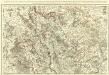
Le Verdunois ou sont les Prevotez dependans du Balliage de l'Evesché de Verdun et de son Chapitre. :
1 : 180000 Mollova mapová sbírka Jaillot, Alexis-Hubert Jaillot, Alexis Hubert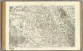
79 Reims.
1 : 86400 Cassini family; Cassini, Cesar-Francois, 1714-1784
Le Duché de Luxembourg divisé en Quartier Walon et Allemand
1 : 140000 Mollova mapová sbírka Jaillot, Alexis-Hubert Jaillot, Alexis Hubert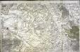
[Reims]
1 Blatt : 60 x 90 cm s.n.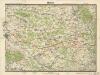
Reims
[Toul]
1 Blatt : 60 x 91 cm Seguin s.n.
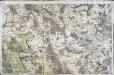
110 Verdun.
1 : 86400 Cassini family; Cassini, Cesar-Francois, 1714-1784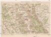
Verdun und Umgebung
1 : 100000 Verdun (Francie) Velhagen & Klasing
Carte du Pais de Retelois. [Karte], in: Gerardi Mercatoris et I. Hondii Newer Atlas, oder, Grosses Weltbuch, Bd. 2, S. 35.
1 Karte aus Atlas Mercator, Gerhard und Hondius, Jodocus Jansson, Jan
Carte du Pais de Retelois. [Karte], in: Novus atlas absolutissimus, Bd. 4, S. 71.
1 Karte aus Atlas Janssonius Offizin
Carte topographique d'Allemagne
1 : 130000 Bar-le-Duc (Francie) Jaeger, Johann Wilhelm Abraham I.W. Iaeger
Le Theatre de Bellone :
Mollova mapová sbírka Schenk, Pieter Braakman, Adriaan
Carte du pays et diocese de Reims
1 : 171000 Remeš (Francie) Chalonnois, Jean Jubrien
Sheet 5, uit: Stanford's large scale map of the seat of war / Stanford's Geographical Estab[lishmen]t
1 : 300000 Stanford's Geographical Establishment, Londen London : Stanford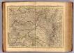
Champagne, Generalite de Chalons.
1 : 336000 L'Isle, Guillaume de, 1675-1726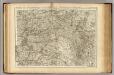
![Verdun / [levée] par les officiers du Corps d'Etat-Major](https://images-2.georeferencer.com/images/iiif/067989012263/full/,300/0/native.jpg)

