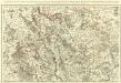
Maps of Verdun
110 Verdun.
1 : 86400 Cassini family; Cassini, Cesar-Francois, 1714-1784
[Toul]
1 Blatt : 60 x 91 cm Seguin s.n.
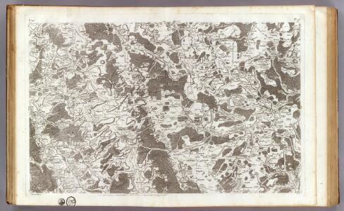
158. Metz, uit: Topographische Uebersichtskarte des Deutschen Reiches / herausgegeben v. d. Kartogr. Abt. d. Königl. Preuß. Landesaufnahme
1 : 200000 titelvariant: Topogr. Übersichtskarte des Deutschen Reiches; Annotatie: Titel boven bladen ook: Topogr. Übersichtskarte des Deutschen Reiches; Annotatie geografische gegevens: Op elk blad twee maatstokken: 10 Kilometer = 5,5 cm; 1 geogr. Meile = 3,6 cm; Legenda onder op elk blad Königlich Preußische Landesaufnahme. Kartographische Abtheilung [S.l : Königlich Preußische Landesaufnahme, Kartographische Abtheilung]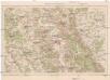
Verdun und Umgebung
1 : 100000 Verdun (Francie) Velhagen & Klasing
[Meurthe-et-Moselle et environ]
1 : 25000 Meurthe-et-Moselle (Francie)
[Mars-la-Tour, Vionville, Rezonville]
1 : 25000 Mars-la-Tour (Francie)
Meßtischblatt [6601] = [3533] : Fentsch, 1882
1 : 250000 Fentsch. - Aufn. 1880, hrsg. 1882. - 1:25000. - [Berlin] : Kgl. Preuss. Landesaufnahme, 1882. - 1 Kt.
[St. Marie aux Chénes, St. Privat, Verneville, Gravelotte, Rezonville]
Gravelotte (Francie)
Meßtischblatt 6901 : Gorze, 1882
1 : 250000 Gorze. - Aufn. 1880, hrsg. 1882. - 1:25000. - [Berlin]: Reichsamt für Landesaufnahme, 1882. - 1 Kt.
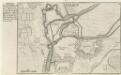
PLAN ET SIEGE DE DAMVILLERS, | Aßiegeé par Monsr. le Mareschal de CHASTILLON | le I jour de Septembre, MDCXXXVII, | et pris le XXV jour d Octobre suivant
A Amsterdam chez Iean Blaeu
[Gravelotte, Rózerieulles]
Gravelotte (Francie)
[St. Marie aux Chénes, St. Privat]
Gravelotte (Francie)
[Tronville]
Mars-la-Tour (Francie)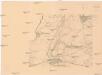
[Mars-la-Tour, Bruville]
Mars-la-Tour (Francie)
[Vionville]
Vionville (Francie)
Plans des ville et citadelle de Verdun
1 : 13000
Verdvn
Mollova mapová sbírka Merian, Matthaeus Merian, Matthäus - dědici
Verdvn
Mollova mapová sbírka Merian, Matthaeus Merian, Matthäus - dědici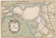
A colored "plan de Verdun
A colored manuscript plan de Verdun, France; "drawn about 1650, on a scale of 95 toises to an inch."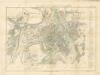
Plan de Verdun
Uerdun.
Mollova mapová sbírka Bodenehr, Gabriel Bodenehr, Gabriel
Meßtischblatt 3551 : Gravelotte, 1901
1 : 250000 Gravelotte. - Aufn. 1880, hrsg. 1882, einz. Nachtr. 1901. - 1:25000. - [Berlin]: Reichsamt für Landesaufnahme, 1901. - 1 Kt.
Meßtischblatt 3543 : Großmövern, 1916
1 : 250000 Großmövern. - Aufn. 1880, hrsg. 1882, B 06, Aufldr. 1916. - 1:25000. - [Berlin]: Reichsamt für Landesaufnahme, 1916. - 1 Kt.
Meßtischblatt 6602 : Hayingen, 1882
1 : 250000 Hayingen. - Aufn. 1880, hrsg. 1882. - 1:25000. - [Berlin]: Reichsamt für Landesaufnahme, 1882. - 1 Kt.
Meßtischblatt 3562 : Ars an der Mosel, 1916
1 : 250000 Ars an der Mosel. - Aufn. 1880, hrsg. 1882, Aufldr. 1916. - 1:25000. - [Berlin]: Kgl. Preuss. Landesaufnahme, 1916. - 1 Kt.
Meßtischblatt 3562 : Ars an der Mosel, 1908
1 : 250000 Ars an der Mosel. - Aufn. 1880, hrsg. 1882, bericht. 1908. - 1:25000. - [Berlin]: Reichsamt für Landesaufnahme, 1908. - 1 Kt.
Meßtischblatt 6902 : Ars (An der Mosel), 1882
1 : 250000 Ars (An der Mosel). - Aufn. 1880. - 1:25000. - [Berlin]: Reichsamt für Landesaufnahme, 1882. - 1 Kt.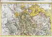
Le Verdunois
1 Karte : Kupferdruck ; 44 x 68 cm Jaillot Alexis Hubert Jaillot
Evesché de Verdun
1 : 240000 Mollova mapová sbírka Sanson, Nicolas Mariette, Pierre