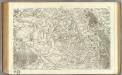
Maps of Marne

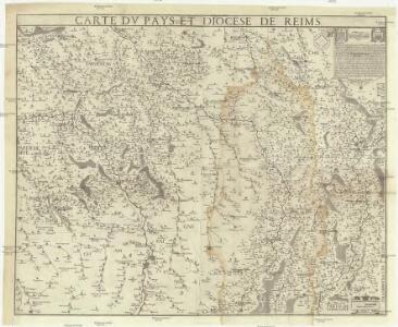
Carte du pays et diocese de Reims
1 : 171000 Remeš (Francie) Chalonnois, Jean Jubrien
Champagne, Generalite de Chalons.
1 : 336000 L'Isle, Guillaume de, 1675-1726
Champagne, Generalite de Chalons.
1 : 336000 L'Isle, Guillaume de, 1675-1726
Stoel des Oorlogs in Champagnes Noorder Deel Teatre de la Guerre en Champagne Septentrione
1 : 250000 Mollova mapová sbírka Allard, Abraham Allart, Abraham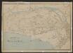
Dioecese De Rheims, et le Païs de Rethel. [Karte], in: Gerardi Mercatoris et I. Hondii Newer Atlas, oder, Grosses Weltbuch, Bd. 2, S. 53.
1 Karte aus Atlas Mercator, Gerhard und Hondius, Jodocus Jansson, Jan
Dioecese De Rheims, et le Païs de Rethel. [Karte], in: Novus atlas absolutissimus, Bd. 4, S. 68.
1 Karte aus Atlas Janssonius Offizin
Diœcese de Rheims et le païs de Rethel
1 Karte : Kupferdruck ; 41 x 53 cm Jubrien; Blaeu; Blaeu apud Guilj. et Joan Blaeuw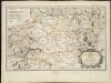
Rhemi : Partie meridionale du dioecese, et archevesché de Rheims en Champagne
1 : 211000
Le Theatre de Bellone :
Mollova mapová sbírka Schenk, Pieter Braakman, Adriaan
Département de la Marne
1 Karte : Kupferdruck ; 41 x 36 cm Capitaine s.n.
Département de la Marne
1 : 260000 Marne (Francie : departement) Houdan, d' P. G. Chanlaire et Dumez
Carte du Pais de Retelois. [Karte], in: Novus atlas absolutissimus, Bd. 4, S. 71.
1 Karte aus Atlas Janssonius Offizin
Carte du Pais de Retelois. [Karte], in: Gerardi Mercatoris et I. Hondii Newer Atlas, oder, Grosses Weltbuch, Bd. 2, S. 35.
1 Karte aus Atlas Mercator, Gerhard und Hondius, Jodocus Jansson, Jan
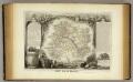
Dept. De La Marne.
1 : 561000 Levasseur, Victor.
Tableau géographique et statistique du département de la Marne
1 : 620000 gravé par Le Gagneur Paris : Baudouin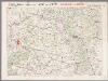
L'Aisne et la Meuse, uit: Le conflict mondial : front occidental
1 : 170000 Annotatie: Ontbreekt: no. 1 en 5-8 Gand : Th. de Graeve
Reims 110, uit: [W. Liebenow's Special-Karte von Mittel-Europa]
1 : 300000 titelvariant: W. Liebenow's Mittel-Europa; Annotatie: Titel boven de bladen: W. Liebenow's Mittel-Europa Johannes Wilhelm Liebenow 1822-1897 Hannover : Hermann Oppermann
Dioecese de Rheims, et le païs de Rethel
1 : 95040
Reims 110, uit: Special-Karte von Mittel-Europa / nach amtlichen Quellen bearbeitet von W. Liebenow
1 : 300000 titelvariant: W. Liebenow's Mittel-Europa; Annotatie: Titel boven de bladen: W. Liebenow's Mittel-Europa Johannes Wilhelm Liebenow 1822-1897 Frankfurt a. M. : Ludwig Ravenstein
Département de la Marne
1 Karte : Kupferdruck ; 49 x 48 cm Houdan au bureau de l'atlas national de France rue Serpente no. 15 et au cabinet bibliographique rue de la vieille Monnoye no. 12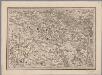
[24], uit: Hydro-Oro und Chorographische General Karte des Koenigreichs der Niederlande und der angrenzenden Länder bis Paris : mit der Angabe der Kunst und Heer-Strassen und der Entfernung der Poststationen / ... zusammengetragen und reducirt von ... Wilhelm Müller
1 : 400000 titelvariant: Generalkarte des Koenigreichs Hannover; Annotatie: 1e supplement bij: Generalkarte des Koenigreichs Hannover (1818) Müller, Wilhelm (fl. 1818) [Hannover : Wilhelm Müller]
Carte du pais de Retelois
1 : 279000 Jubrien, Jean Janssonius, Johannes apud Ioannem Ianßonium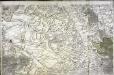
[Reims]
1 Blatt : 60 x 90 cm s.n.
Reliefkarte des Argonnenwaldes und der Gegend von Verdun
Franckh'sche Verlagshandlung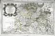
Rhemi
1 Karte : Kupferdruck ; 34 x 54 cm Sanson; Robert de Vaugondy; Perelle chés le Sr. Robert g. du roi quai de l horloge
Suessones populi belgicæ secundæ
1 Karte : Kupferdruck ; 40 x 47 cm Sanson; Robert de Vaugondy chés le Sr. Robert geographe ord. du roi quai de l'Horloge du Palais
Map illustrating described itinerary in Aisne-Marne region
1 : 200000 Shows troop movements in the Aisne and Marne River areas including roads and towns from July 18th to October 12th."7426." United States. Army. Engineer Reproduction Plant. Washington, D.C. : Engineer Reproduction Plant, U.S. Army.
Evesché de Laon
1 Karte : Kupferdruck ; 40 x 45 cm Sanson; Robert de Vaugondy chés le Sr. Robert geog. ordinaire du roi quai de l'horloge