Maps of Laon

Reims 110, uit: [W. Liebenow's Special-Karte von Mittel-Europa]
1 : 300000 titelvariant: W. Liebenow's Mittel-Europa; Annotatie: Titel boven de bladen: W. Liebenow's Mittel-Europa Johannes Wilhelm Liebenow 1822-1897 Hannover : Hermann Oppermann
Reims 110, uit: Special-Karte von Mittel-Europa / nach amtlichen Quellen bearbeitet von W. Liebenow
1 : 300000 titelvariant: W. Liebenow's Mittel-Europa; Annotatie: Titel boven de bladen: W. Liebenow's Mittel-Europa Johannes Wilhelm Liebenow 1822-1897 Frankfurt a. M. : Ludwig Ravenstein
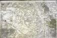
Dioecese de Rheims, et le païs de Rethel
1 : 95040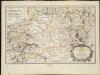
Rhemi : Partie meridionale du dioecese, et archevesché de Rheims en Champagne
1 : 211000
Evesché de Laon
1 Karte : Kupferdruck ; 40 x 45 cm Sanson; Robert de Vaugondy chés le Sr. Robert geog. ordinaire du roi quai de l'horloge
Map illustrating described itinerary in Aisne-Marne region
1 : 200000 Shows troop movements in the Aisne and Marne River areas including roads and towns from July 18th to October 12th."7426." United States. Army. Engineer Reproduction Plant. Washington, D.C. : Engineer Reproduction Plant, U.S. Army.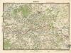
Soissons

Suessones populi belgicæ secundæ
1 Karte : Kupferdruck ; 40 x 47 cm Sanson; Robert de Vaugondy chés le Sr. Robert geographe ord. du roi quai de l'Horloge du Palais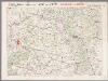
L'Aisne et la Meuse, uit: Le conflict mondial : front occidental
1 : 170000 Annotatie: Ontbreekt: no. 1 en 5-8 Gand : Th. de Graeve
Carte du pais de Retelois
1 : 279000 Jubrien, Jean Janssonius, Johannes apud Ioannem Ianßonium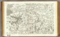
44 Soissons.
1 : 86400 Cassini family; Cassini, Cesar-Francois, 1714-1784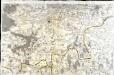
[Soissons]
1 Blatt : 60 x 91 cm s.n.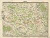
Reims
[Reims]
1 Blatt : 60 x 90 cm s.n.
Carte de la France
1 : 100000 Francie Librairie Hachette
Plan‘‘sraženija pri Kraoně, 23. Fevralja 1814 goda
Frankreich Craonne Befreiungskriege <1813-1815>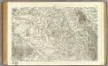
79 Reims.
1 : 86400 Cassini family; Cassini, Cesar-Francois, 1714-1784
Zusammendruck Faucoucourt
1 : 25000 Pikardie (Francie) Vermessungs-Abteilung 25
Gruppe Crépy
1 : 25000 Vermessungs-Abteilung 14
Gruppe Sissonne
1 : 25000 Pikardie (Francie) Vermessungs-Abteilung 14
Gruppe Crépy
1 : 25000 Vermessungs-Abteilung 14
Plan‘‘sraženija pri Laoně, 25 I 26 fevralja 1814 g.
Frankreich Laon Befreiungskriege <1813-1815>
Die Schlacht von Laon den 9ten März 1814
Brügner, Carl; Brose, Karl Heinrich; Prêtre, Jean Gabriel Prêtre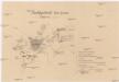
Nachtgefecht bei Laon

Die Schlacht von Laon den 9ten März 1814
1 : 49000 Laon (Francie) Bruegner, C. Brose, H. Pretre
Brimont S. O.

Zusammendruck Berrieux
1 : 10000 Pikardie (Francie) Vermessungs-Abteilung 14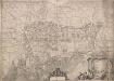
Plan general de Reims et de ses environs
Plan général de Reims et de ses environs, par le Sr le Gendre. 0
Plan général de la ville de Reims et de ses environs, avec ses projets et embélissements
1 : 6500 titelvariant: Plan de Rheims; Annotatie: Omslagtitel: Plan de Rheims A Rheims : chez Ledoyen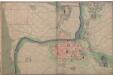
![Reims 110, uit: [W. Liebenow's Special-Karte von Mittel-Europa]](https://images-2.georeferencer.com/images/iiif/680106543823/full/,300/0/native.jpg)

