Maps of Château-Thierry

Suessones populi belgicæ secundæ
1 Karte : Kupferdruck ; 40 x 47 cm Sanson; Robert de Vaugondy chés le Sr. Robert geographe ord. du roi quai de l'Horloge du Palais
Département de l'Aisne
1 Karte : Kupferdruck ; 55 x 40 cm Houdan au bureau de l'atlas national rue de la Harpe no. 26 et au dépôt de cet atlas placé au cabinet bibliographique rue de la Monnoye no. 5
Map illustrating described itinerary in Aisne-Marne region
1 : 200000 Shows troop movements in the Aisne and Marne River areas including roads and towns from July 18th to October 12th."7426." United States. Army. Engineer Reproduction Plant. Washington, D.C. : Engineer Reproduction Plant, U.S. Army.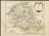
Suessones : Evesche de Soissons : où sont les Balliages et eslections de Soissons, Chasteau Thierry, et Crespy en Valois &c.
1 : 222000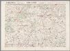
L'Aisne et la Marne, uit: Le conflict mondial : front occidental
1 : 170000 Annotatie: Ontbreekt: no. 1 en 5-8 Gand : Th. de Graeve
Valesium Ducatus. Valois. [Karte], in: Novus atlas absolutissimus, Bd. 4, S. 100.
1 Karte aus Atlas Janssonius Offizin
Valesium Ducatus. Valois. [Karte], in: Le théâtre du monde, ou, Nouvel atlas contenant les chartes et descriptions de tous les païs de la terre, Bd. 2, S. 39.
1 Karte aus Atlas Blaeu, Willem Janszoon und Blaeu, Joan Blaeu, Willem Janszoon
Valesium Ducatus. Valois. [Karte], in: Novus Atlas, das ist, Weltbeschreibung, Bd. 2, S. 39.
1 Karte aus Atlas Blaeu, Joan Blaeu, Willem Janszoon
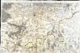
[Soissons]
1 Blatt : 60 x 91 cm s.n.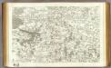
44 Soissons.
1 : 86400 Cassini family; Cassini, Cesar-Francois, 1714-1784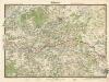
Soissons

Valesium Ducatus. Valois. [Karte], in: Theatrum orbis terrarum, sive, Atlas novus, Bd. 2, S. 28.
1 Karte aus Atlas Blaeu, Joan Blaeu, Willem Janszoon
VALESIVM | Ducatus. | VALOIS
Guiljelmus Blaeu | excudit
Karta dlja ob‘‘jasnenija sraženiji pri Šampoberě, Monmiralě i Vošaně s‘‘ 29. Janv. Po 3 fevr. 1814 g.
Frankreich Champaubert Montmirail (Marne) Befreiungskriege <1813-1815> Champaubert / Schlacht
[Valesivm ducatus]
1 Karte : Kupferdruck ; 39 x 49 cm Janssonius Joannes Janssonius excudebat
Valesivm ducatus
1 Karte : Kupferdruck ; 38 x 48 cm Blaeu Guiljelmus Blaeu excudit
Plan‘‘sraženija pri Kraoně, 23. Fevralja 1814 goda
Frankreich Craonne Befreiungskriege <1813-1815>
Zusammendruck Barisis
1 : 25000 Pikardie (Francie) Vermessungs-Abteilung 25
Plan général de la forêt de Retz, située sur les communes Retheuil ... (Départment de l'Oise)
1 : 20000 Paris : Ginain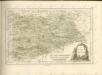
Zusammendruck Carlepont
1 : 25000 Pikardie (Francie) Vermessungs-Abteilung 25
Zusammendruck Faucoucourt
1 : 25000 Pikardie (Francie) Vermessungs-Abteilung 25
Gruppe Sissonne
1 : 25000 Pikardie (Francie) Vermessungs-Abteilung 14
Gruppe Crépy
1 : 25000 Vermessungs-Abteilung 14
Plan‘‘sraženija pri Laoně, 25 I 26 fevralja 1814 g.
Frankreich Laon Befreiungskriege <1813-1815>
Die Schlacht von Laon den 9ten März 1814
Brügner, Carl; Brose, Karl Heinrich; Prêtre, Jean Gabriel Prêtre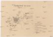
Nachtgefecht bei Laon

Die Schlacht von Laon den 9ten März 1814
1 : 49000 Laon (Francie) Bruegner, C. Brose, H. Pretre


