Maps of Soissons

Valesium Ducatus. Valois. [Karte], in: Novus atlas absolutissimus, Bd. 4, S. 100.
1 Karte aus Atlas Janssonius Offizin
Valesium Ducatus. Valois. [Karte], in: Le théâtre du monde, ou, Nouvel atlas contenant les chartes et descriptions de tous les païs de la terre, Bd. 2, S. 39.
1 Karte aus Atlas Blaeu, Willem Janszoon und Blaeu, Joan Blaeu, Willem Janszoon
Valesium Ducatus. Valois. [Karte], in: Novus Atlas, das ist, Weltbeschreibung, Bd. 2, S. 39.
1 Karte aus Atlas Blaeu, Joan Blaeu, Willem Janszoon

Valesium Ducatus. Valois. [Karte], in: Theatrum orbis terrarum, sive, Atlas novus, Bd. 2, S. 28.
1 Karte aus Atlas Blaeu, Joan Blaeu, Willem Janszoon
[23], uit: Hydro-Oro und Chorographische General Karte des Koenigreichs der Niederlande und der angrenzenden Länder bis Paris : mit der Angabe der Kunst und Heer-Strassen und der Entfernung der Poststationen / ... zusammengetragen und reducirt von ... Wilhelm Müller
1 : 400000 titelvariant: Generalkarte des Koenigreichs Hannover; Annotatie: 1e supplement bij: Generalkarte des Koenigreichs Hannover (1818) Müller, Wilhelm (fl. 1818) [Hannover : Wilhelm Müller]
VALESIVM | Ducatus. | VALOIS
Guiljelmus Blaeu | excudit
Le Theatre de Bellone :
Mollova mapová sbírka Schenk, Pieter Braakman, Adriaan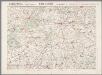
L'Aisne et la Marne, uit: Le conflict mondial : front occidental
1 : 170000 Annotatie: Ontbreekt: no. 1 en 5-8 Gand : Th. de Graeve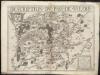
Description du pais de Valois
1 : 180000
Le pais de Valois
1 Karte : Kupferdruck ; 36 x 48 cm Mercator; Hondius Henricus Hondius
[Valesivm ducatus]
1 Karte : Kupferdruck ; 39 x 49 cm Janssonius Joannes Janssonius excudebat
Valesivm ducatus
1 Karte : Kupferdruck ; 38 x 48 cm Blaeu Guiljelmus Blaeu excudit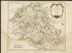
Suessones : Evesche de Soissons : où sont les Balliages et eslections de Soissons, Chasteau Thierry, et Crespy en Valois &c.
1 : 222000
Suessones populi belgicæ secundæ
1 Karte : Kupferdruck ; 40 x 47 cm Sanson; Robert de Vaugondy chés le Sr. Robert geographe ord. du roi quai de l'Horloge du Palais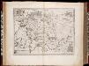
Ager Parisiensis vulgo l'Isle de France / Fr. Guilloterius ... describ. et Petro Pithoeo dedicabat
1 : 150000 Annotatie: Oorspr. verschenen in: Novus atlas ... - Amsterdami : apud Guiljelmum Blaeu, 1635; Origineel is Blad 15 in atlas factice Guilloterius, Fr.; Pithou, Pierre [Amsterdam : apud Guiljelmum Blaeu]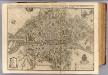
Paris.
1 : 17000 L'Isle, Guillaume de, 1675-1726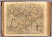
Diocese de Beauvais.
1 : 170000 L'Isle, Guillaume de, 1675-1726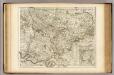
Diocese de Beauvais.
1 : 170000 L'Isle, Guillaume de, 1675-1726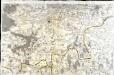
[Soissons]
1 Blatt : 60 x 91 cm s.n.
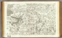
Map illustrating described itinerary in Aisne-Marne region
1 : 200000 Shows troop movements in the Aisne and Marne River areas including roads and towns from July 18th to October 12th."7426." United States. Army. Engineer Reproduction Plant. Washington, D.C. : Engineer Reproduction Plant, U.S. Army.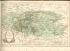
44 Soissons.
1 : 86400 Cassini family; Cassini, Cesar-Francois, 1714-1784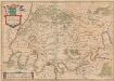
Ager Parisiensis Vulgo L'Isle De France [Karte], in: Novus atlas absolutissimus, Bd. 4, S. 94.
1 Karte aus Atlas Janssonius Offizin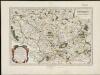
Bellovaci et Silvanectes, les Eveschés de Beauvais et Senlis : Comté et Pairrie de Beauvais : Les Balliages de Beauvais, Clermont, et Senlis : Les Eslections de Beauvais, Clermont, Senlis, et Compiegne
1 : 211000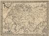
L'Isle de France. Parisiensis Agri Descrip. [Karte], in: Theatrum orbis terrarum, S. 126.
1 Karte aus Atlas Ortelius, Abraham Vrients, Jan Baptista
Ager Parisiensis Vulgo L'Isle De France [...] [Karte], in: Le théâtre du monde, ou, Nouvel atlas contenant les chartes et descriptions de tous les païs de la terre, Bd. 2, S. 45.
1 Karte aus Atlas Blaeu, Willem Janszoon und Blaeu, Joan Blaeu, Willem Janszoon
Ager Parisiensis Vulgo L'Isle De France [Karte], in: Theatrum orbis terrarum, sive, Atlas novus, Bd. 2, S. 19.
1 Karte aus Atlas Blaeu, Joan Blaeu, Willem Janszoon
Ager Parisiensis Vulgo L'Isle De France [Karte], in: Novus Atlas, das ist, Weltbeschreibung, Bd. 2, S. 45.
1 Karte aus Atlas Blaeu, Joan Blaeu, Willem Janszoon
![Valesium Ducatus. Valois. [Karte], in: Novus atlas absolutissimus, Bd. 4, S. 100.](https://images-2.georeferencer.com/images/iiif/577197855154/full/,300/0/native.jpg)

