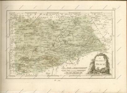
Maps of Meaux

Evesché de Meaux
1 Karte auf 2 Blättern : Kupferdruck ; 76 x 67 cm Chevalier; Jaillot; Cordier chez le Sr. Iaillot geographe du roy joignant les grands Augustins au 2 globes
Ager Parisiensis vulgo l'Isle de France / Fr. Guilloterius ... describ. et Petro Pithoeo dedicabat
1 : 150000 Annotatie: Oorspr. verschenen in: Novus atlas ... - Amsterdami : apud Guiljelmum Blaeu, 1635; Origineel is Blad 15 in atlas factice Guilloterius, Fr.; Pithou, Pierre [Amsterdam : apud Guiljelmum Blaeu]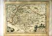
L'Isle de France
1 Karte : Kupferdruck ; 17 x 24 cm Mercator Cloppenburgh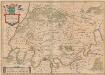
Ager Parisiensis Vulgo L'Isle De France [Karte], in: Novus atlas absolutissimus, Bd. 4, S. 94.
1 Karte aus Atlas Janssonius Offizin
Valesium Ducatus. Valois. [Karte], in: Theatrum orbis terrarum, sive, Atlas novus, Bd. 2, S. 28.
1 Karte aus Atlas Blaeu, Joan Blaeu, Willem Janszoon
Ager Parisiensis Vulgo L'Isle De France [Karte], in: Gerardi Mercatoris et I. Hondii Newer Atlas, oder, Grosses Weltbuch, Bd. 2, S. 59.
1 Karte aus Atlas Mercator, Gerhard und Hondius, Jodocus Jansson, Jan
L'Isle de France. Parisiensis Agri Descriptio. [Karte], in: Gerardi Mercatoris Atlas, sive, Cosmographicae meditationes de fabrica mundi et fabricati figura, S. 235.
1 Karte aus Atlas Mercator, Gerhard Montanus, Petrus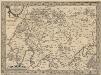
L'Isle de France. Parisiensis Agri Descrip. [Karte], in: Theatrum orbis terrarum, S. 126.
1 Karte aus Atlas Ortelius, Abraham Vrients, Jan Baptista
Ager Parisiensis Vulgo L'Isle De France [...] [Karte], in: Le théâtre du monde, ou, Nouvel atlas contenant les chartes et descriptions de tous les païs de la terre, Bd. 2, S. 45.
1 Karte aus Atlas Blaeu, Willem Janszoon und Blaeu, Joan Blaeu, Willem Janszoon
Ager Parisiensis Vulgo L'Isle De France [Karte], in: Theatrum orbis terrarum, sive, Atlas novus, Bd. 2, S. 19.
1 Karte aus Atlas Blaeu, Joan Blaeu, Willem Janszoon
Ager Parisiensis Vulgo L'Isle De France [Karte], in: Novus Atlas, das ist, Weltbeschreibung, Bd. 2, S. 45.
1 Karte aus Atlas Blaeu, Joan Blaeu, Willem Janszoon
AGER PARISIENSIS | Vulgo | L'ISLE DE FRANCE
Fr. Guilloterius Bitur. Viu. describ. | et Cl. V. Petro Pithoeo I.C. | dedicabat Apud Guiljelmum Blaeu


[Valesivm ducatus]
1 Karte : Kupferdruck ; 39 x 49 cm Janssonius Joannes Janssonius excudebat
Valesivm ducatus
1 Karte : Kupferdruck ; 38 x 48 cm Blaeu Guiljelmus Blaeu excudit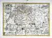
Ager Parisiensis vulgo l'Isle de France
1 Karte : Kupferdruck ; 31 x 45 cm Guillotière; Schenk; Valck apud Gerardum Valk et Petrum Schenk
Ager Parisiensis vulgo l'Isle de France
1 Karte : Kupferdruck ; 36 x 49 cm Guillotière; Blaeu apud Guiljelmum Blaeu
L'Isle de France
1 Karte : Kupferdruck ; 32 x 45 cm Guillotière; Hondius; Mercator Henricus Hondius
L'Isle de France
1 Karte : Kupferdruck ; 32 x 45 cm Guillotière; Hondius; Mercator Jodocus Hondius
Ager parisiensis vulgo l'Isle de France
1 : 144000 Île-de-France (Francie) Guillo, Fr. Pithou, Pierre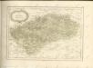

Karta dlja ob‘‘jasnenija sraženiji pri Šampoberě, Monmiralě i Vošaně s‘‘ 29. Janv. Po 3 fevr. 1814 g.
Frankreich Champaubert Montmirail (Marne) Befreiungskriege <1813-1815> Champaubert / Schlacht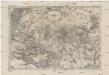
Plan von Paris
1 : 49240 Paříž (Francie) Fritz Rudolf Lechner
Nord-Est: Paris Et Ses Environs.
1 : 40000 Service Geologique Des Mines (France)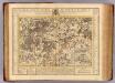
Diocese de Senlis.
1 : 150000 L'Isle, Guillaume de, 1675-1726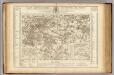
Diocese de Senlis.
1 : 150000 L'Isle, Guillaume de, 1675-1726
Paris, France.
1 : 97000 Colton, G.W.