Maps of Verdun
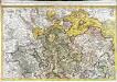
Le Verdunois
1 Karte : Kupferdruck ; 44 x 68 cm Jaillot Alexis Hubert Jaillot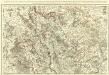
Le Verdunois ou sont les Prevotez dependans du Balliage de l'Evesché de Verdun et de son Chapitre. :
1 : 180000 Mollova mapová sbírka Jaillot, Alexis-Hubert Jaillot, Alexis Hubert
Evesché de Verdun
1 : 240000 Mollova mapová sbírka Sanson, Nicolas Mariette, Pierre
Verdun 111, uit: Special-Karte von Mittel-Europa / nach amtlichen Quellen bearbeitet von W. Liebenow
1 : 300000 titelvariant: W. Liebenow's Mittel-Europa; Annotatie: Titel boven de bladen: W. Liebenow's Mittel-Europa Johannes Wilhelm Liebenow 1822-1897 Frankfurt a. M. : Ludwig Ravenstein
Verdun 111, uit: [W. Liebenow's Special-Karte von Mittel-Europa]
1 : 300000 titelvariant: W. Liebenow's Mittel-Europa; Annotatie: Titel boven de bladen: W. Liebenow's Mittel-Europa Johannes Wilhelm Liebenow 1822-1897 Hannover : Hermann Oppermann
Verodvni
1 Karte : Kupferdruck ; 41 x 47 cm Sanson; Robert de Vaugondy chés le Sr. Robert geographe ord. du roi quai de l'horloge
Verodvni
1 Karte : Kupferdruck ; 41 x 47 cm Sanson; Mariette chez P. Mariette
Carte dressee specialement pour les Membres de la Conference...

Reliefkarte des Argonnenwaldes und der Gegend von Verdun
Franckh'sche Verlagshandlung
[Toul]
1 Blatt : 60 x 91 cm Seguin s.n.
110 Verdun.
1 : 86400 Cassini family; Cassini, Cesar-Francois, 1714-1784
158. Metz, uit: Topographische Uebersichtskarte des Deutschen Reiches / herausgegeben v. d. Kartogr. Abt. d. Königl. Preuß. Landesaufnahme
1 : 200000 titelvariant: Topogr. Übersichtskarte des Deutschen Reiches; Annotatie: Titel boven bladen ook: Topogr. Übersichtskarte des Deutschen Reiches; Annotatie geografische gegevens: Op elk blad twee maatstokken: 10 Kilometer = 5,5 cm; 1 geogr. Meile = 3,6 cm; Legenda onder op elk blad Königlich Preußische Landesaufnahme. Kartographische Abtheilung [S.l : Königlich Preußische Landesaufnahme, Kartographische Abtheilung]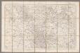
Verdun / [levée] par les officiers du Corps d'Etat-Major
1 : 80000 Corps d'Etat-Major [Paris : Dépôt de la Guerre]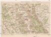
Verdun und Umgebung
1 : 100000 Verdun (Francie) Velhagen & Klasing
[Meurthe-et-Moselle et environ]
1 : 25000 Meurthe-et-Moselle (Francie)
[Mars-la-Tour, Vionville, Rezonville]
1 : 25000 Mars-la-Tour (Francie)
Meßtischblatt 6901 : Gorze, 1882
1 : 250000 Gorze. - Aufn. 1880, hrsg. 1882. - 1:25000. - [Berlin]: Reichsamt für Landesaufnahme, 1882. - 1 Kt.
Meßtischblatt [6601] = [3533] : Fentsch, 1882
1 : 250000 Fentsch. - Aufn. 1880, hrsg. 1882. - 1:25000. - [Berlin] : Kgl. Preuss. Landesaufnahme, 1882. - 1 Kt.
Meßtischblatt 35522 : Deutschoth, 1908
1 : 250000 Deutschoth. - Aufn. 1880, hrsg. 1882, [gedr. 19]08. - 1:25000. - [Berlin]: Reichsamt für Landesaufnahme, 1908. - 1 Kt.
[St. Marie aux Chénes, St. Privat, Verneville, Gravelotte, Rezonville]
Gravelotte (Francie)
Skizze zum Gefechte bei Voncq am Abend des 29.8.70
1 : 80000
PLAN ET SIEGE DE DAMVILLERS, | Aßiegeé par Monsr. le Mareschal de CHASTILLON | le I jour de Septembre, MDCXXXVII, | et pris le XXV jour d Octobre suivant
A Amsterdam chez Iean Blaeu
[Gravelotte, Rózerieulles]
Gravelotte (Francie)
[St. Marie aux Chénes, St. Privat]
Gravelotte (Francie)
[Tronville]
Mars-la-Tour (Francie)
[Mars-la-Tour, Bruville]
Mars-la-Tour (Francie)
[Vionville]
Vionville (Francie)
Plans des ville et citadelle de Verdun
1 : 13000
Longwic oder Longwy :
1 : 2000 Mollova mapová sbírka Bodenehr, Gabriel Bodenehr, Gabriel
Verdvn
Mollova mapová sbírka Merian, Matthaeus Merian, Matthäus - dědici


