Maps of Asia
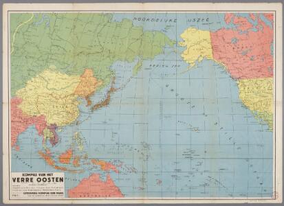
Kompas van het Verre Oosten : bevattende: Aziatisch Rusland, China, Japan, Philippijnen, Nederl. Indië, Molukken, Fransch Indo-China, Noord-Australië en Westelijk Noord-Amerika
1 : 20000000 Den Haag : Kompas
War map Atlantic, Eurasia, Africa, Pacific Ocean.
Sun Oil Company
Asien
Plastischer Schul-Atlas über alle Theile der Erde : in 24 Karten Woldermann, G Verlag von P. Eckerlein
Asia
A new general atlas of modern geography, consisting of a complete collection of maps of the four quarters of the globe Wyld, James James Wyld
The River systems of Asia & Europe
The physical atlas Johnston, Alexander Keith William Blackwood & Sons
Asia secundum novas celeberrimi de l'Isle projectiones aliorumque recentissimorum geographorum observationes concinnata
1 : 22000000 cura et sumtibus M. Alb. et G. Fr. Lotter Aug. Vind : [Lotter]
[Recto], uit: Azië / aardrijksk. medew. G.J. de Vries
1 : 58000000 titelvariant: Landen van Azië met de hoofdsteden; Annotatie: Titel boven de kaart: Landen van Azië met de hoofdsteden Vries, Gerben Johannes de Sneek : Tonnema
IV. Charte für die allgemeine Geschichte von Augustus Alleinherrschaft bis auf den Untergang des weströmischen Reichs : d.i. von 30 v. Chr. bis 476 nach Christus
Entworfen von F.W. Benicken gez. von C.F. Weiland ; in Stein gravirt v. A. Falger Weimar : im Verlage des L. Industrie-Comptoirs
Asien
Allgemeiner Atlas [Walch, Johannes] im Verlag bei Johannes Walch
II. Charte für die allgemeine Geschichte von Troja’s Zerstörung bis auf den Anfang der Perserkriege : d.i. von 1184 bis 501 vor Christus
Entworfen von F.W. Benicken Weimar : im Verlage des L. Industrie-Comptoirs
ASIE

Nord-Amerika
Plastischer Schul-Atlas über alle Theile der Erde : in 24 Karten Woldermann, G Verlag von P. Eckerlein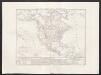
Carta generale dell'America settentrionale
1 : 25000000 Marzolla, Benedetto Real Litografia Militare
Asia
Hand-Atlas über alle Theile der Erde und über das Weltgebäude Stieler, Adolf Justus Perthes
Afrique : d'après les documents les plus récents et les derniers traitès
1 : 18000000 Giffault, E Le Temps Bureaux
Europe spheroidale.
1 : 41000000 Garnier, F. A., 1803-1863
Asia
Stieler's Hand-Atlas Stieler, Adolf bei Justus Perthes
Nieuwe kaart van het oostelykste deel der weereld, dienende tot aanwyzing van de scheepstogten der Nederlanderen naar Oostindië : volgens de laatste ontdekkingen
Te Amsterdam : by Is. Tirion
N. Hemisphere, plane of London.
1 : 41000000 Thomson, John
Nord-Amerika
Volksschul-Atlas über alle Teile der Erde Lange, Henry Druck und Verlag von Georg Westermann
Vertheilung der Luftströmungen
země světa Gräf, C. Dellinger, A. Geographisches Institut
Schlegel's Versuch Einer Schlangen-Karte.
1 : 165000000 Berghaus, Heinrich
Vergleichendes Tableau der Länge der Ströme und der Grösse der Seen der Erde in geograph. Meilen zu 15 am Grad
země světa Desjardin, Constantin J. Bermann
Asia
Hand-Atlas über alle Theile der Erde nach dem neuesten Zustande und über das Weltgebäude Stieler, Adolf bei Justus Perthes
Karte von der Erde oestlicher und westlicher Halbkugel
země světa Reilly, Franz Johann Josef von Alberti, Ignaz von Franz Ioh. Ios. von Reilly
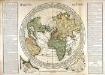
Orbis terrae compendiosa descriptio
země světa Mercator, Rumold Porro, Girolamo Rumoldus Mercator
[Zoological Geography, Geographical Division and Distribution of the Birds of Europe]
The physical atlas Johnston, Alexander Keith William Blackwood & Sons
[Zoological Geography, Geographical Division & Distribution of Rodentia (Gnawing Animals)]
The physical atlas Johnston, Alexander Keith William Blackwood & Sons
[Verbreitung der vorzüglicheren Säugethiere in der neuen Welt]
Zweiter Band, enthaltend in vier Abtheilungen die Vertheilung der Organismen: 5. Pflanzen-Geographie, 6. Thier-Geographie, 7. Anthropographie, 8. Ethnographie Humboldt, Alexander von Verlag von Justus Perthes
Die obere oder nordliche Halbkugel der Erde
1 Karte : Kupferdruck ; Durchmesser 41 cm Bode; Gürsch F. Nicolai
Hémisphère supérieur de la mappemonde
1 Karte : Kupferdruck ; Durchmesser 59 cm Chrysologue; Delahaye s.n.