Maps of Asia

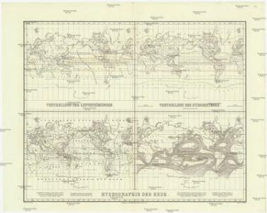
Vertheilung der Luftströmungen
země světa Gräf, C. Dellinger, A. Geographisches Institut
Carte générale de toutes les parties connues de la surface de la terre en carte réduite
země světa Bonne, Rigobert
Asia
Hand-Atlas über alle Theile der Erde nach dem neuesten Zustande und über das Weltgebäude Stieler, Adolf bei Justus Perthes
Planisphere physique.
1 : 60000000 L'Isle, Guillaume de, 1675-1726
World on Mercator's Projection.
1 : 60000000 Rand McNally and Company
[Zoological Geography, Geographical Division & Distribution of Carnivora]
The physical atlas Johnston, Alexander Keith William Blackwood & Sons
Atlas über die Entwicklung von Industrie und Handel der Schweiz in dem Zeitraume vom Jahr 1770 bis zum Jahr 1870
1 : 500000 Absatzgebiete des Schweizerischen Ausfuhrhandels 1770 Wartmann, Hermann Wurster Randegger & Co.
Verbreitung der Vögel II.
Atlas der Tierverbreitung Marshall, William Justus Perthes
Health, disease.
1 : 67000000 Johnston, Alexander Keith, 1804-1871
Verbreitung der Vögel I.
Atlas der Tierverbreitung Marshall, William Justus Perthes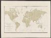
Atlas über die Entwicklung von Industrie und Handel der Schweiz in dem Zeitraume vom Jahr 1770 bis zum Jahr 1870
1 : 500000 Absatzgebiete des Schweizerischen Ausfuhrhandels 1820 Wartmann, Hermann Wurster Randegger & Co.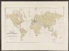
Atlas über die Entwicklung von Industrie und Handel der Schweiz in dem Zeitraume vom Jahr 1770 bis zum Jahr 1870
1 : 500000 Orientierungsblatt Absatzgebiete Wartmann, Hermann Wurster Randegger & Co.
Planisphere physique où l'on voit du pole septentrional ce que l'on connoît de terres et de mers
1 Karte : Kupferdruck ; Durchmesser 34 cm Buache; Dezauche; Desbruslins chez Dezauche succ.r des Srs. De l'Isle et Buache ... rue des Noyers près celle des Anglois
Planisphere physique où l'on voit du pole septentrional ce que l'on connoît de terres et de mers
1 Karte : Kupferdruck ; Durchmesser 34 cm, Blattgrösse 46 x 60 cm Buache; Desbruslins Philippe Buache sur le quay de l'Horloge du Palais
Weltkarte zur Uebersicht der vorzügluchsten Varietaeten des Menschen, nach Blumenbach'schen Systeme
1 : 82300000 entworfen und gezeichnet von C.F. Weiland nach Bory de St. Vincent entworfen und gezeichnet von C.F. Weiland Weimar : Im Verlage des Geograph. Instituts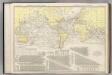
Steamship Routes of The World.
1 : 60000000 Rand McNally and Company
Linien gleicher magnetischer Inklination (Isoklinen)
Atlas des Erdmagnetismus Neumayer, Georg Justus Perthes
Mappe monde ou carte générale du globe terrestre
země světa Robert de Vaugondy, Didier Arrivet Rue du Jardin
[Verbreitungsbezirke der wichtigsten Kulturgewächse]
Zweiter Band, enthaltend in vier Abtheilungen die Vertheilung der Organismen: 5. Pflanzen-Geographie, 6. Thier-Geographie, 7. Anthropographie, 8. Ethnographie Humboldt, Alexander von Verlag von Justus Perthes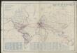
Airways of the world on Mercator's projection
1 : 40600000 Briesemeister, William A. Aeronautic Maps Association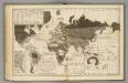
Moral, political World.
1 : 133000000 Woodbridge, William C.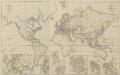
XIII. Charte für die allgemeine Geschichte von Friedrich IIten Tode bis auf den Frieden von Presburg : d.i. von 1786 bis 1805 n. Christus
Entworfen von F.W. Benicken grav. von A. Falger Weimar : im Verlage des L. Industrie-Comptoirs
[Survey of the Geographical distribution and cultivation of the most important Plants which are used as food for man]
The physical atlas Johnston, Alexander Keith William Blackwood & Sons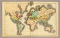
(World)
1 : 130000000 Willard, Emma
Asia
Stieler's Hand-Atlas Stieler, Adolf bei Justus Perthes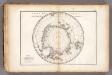
Carte des glaces australes.
1 : 42000000 Vincent
Geographische Verbreitung der Menschen-Rassen.
1 : 140000000 Berghaus, Heinrich
Mercator's Chart.
1 : 91000000 Lucas, Fielding Jr.
Fluthwechsel, Tidenströme, Gang der Hafenzeiten
Atlas der Hydrographie Berghaus, Hermann Justus Perthes