Maps of United Kingdom

Feuille 16 (B III), uit: Carte géologique internationale de l'Europe : la carte, votée au congrès géologique international de Bologne en 1881, est exécutée conformément aux décisions d'une commission internationale, avec le concours des gouvernements, sous le dir. de M.M. Beyrich et Hauchecorne
Annotatie: Blad 48 gamme des couleurs; blad 49: bladwijzer en titelblad Heinrich Ernst Beyrich 1815-1896; Wi. Hauchecorne Berlin : Reimer / (Berlin: Institut lithographique)
British Islands.
1 : 2300000 Lizars, Daniel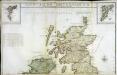
Les isles Britanniques, 1
2 Blätter : 50 x 85 cm Desnos
Grossbritannien und Ireland

[Schotland mit der Nördlichen Spitze von England]
Stieler's Hand-Atlas Stieler, Adolf bei Justus Perthes
Pas-Caart vant Canaal 't Amsterdam. [Karte], in: De Nieuwe Groote Vermeerderde Zee-Atlas ofte Water-Werelt, S. 41.
1 Karte aus Atlas Doncker, Hendrick
Parliamentary map, British Isles.
1 : 1774080 Stanford, Edward
Britain in the Dark Ages
1 : 1000000 Velká Británie Ordnance Survey of the Great Britain
Grossbritannien, Ireland.
1 : 3800000 Flemming, Carl
United Kingdom of England, Scotland and Ireland.
1 : 4500000 Worcester, J. E.
Iles Britanniques.
1 : 2500000 Lapie, M. (Pierre), 1779-1850
Iles Britanniques.
1 : 2470000 Levasseur, E.
[Schotland mit der Nördlichen Spitze von England]
Hand-Atlas über alle Theile der Erde nach dem neuesten Zustande und über das Weltgebäude Stieler, Adolf bei Justus Perthes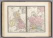
Iles Britanniques et Germanie Anciennes.
Levasseur, E.
Railway map, British Isles.
1 : 1774080 Stanford, Edward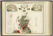
Geological, palaeontological map British Islands.
1 : 1550000 Johnston, Alexander Keith, 1804-1871
Bretagne Anglo Saxonne, 800 ans apres J.C.
1 : 4500000 Houze, Antoine Philippe
Angleterre, Ecosse, Irlande et Man 1100 a 1280.
1 : 4500000 Houze, Antoine Philippe
Angleterre, Irelande & Ecosse 1281 a 1400.
1 : 4500000 Houze, Antoine Philippe
Britischen Inseln.
1 : 1800000 Kiepert, Heinrich, 1818-1899
British Islands.
1 : 5500000 Fitch, George W.
Gt. Britain, Ireland.
1 : 4800000 Mitchell, Samuel Augustus
Iles Britanniques.
1 : 2500000 Andriveau-Goujon, J.
British Isles.
1 : 5000000 Adams, Daniel
Partie, l'Angleterre. Europe 7.
1 : 1641836 Vandermaelen, Philippe, 1795-1869
General - Karte von Europa mit Klein - Asien und dem nördlichen Afrika

Scotia antiqva
2 Karten auf 1 Blatt : Kupferdruck ; Bildgrösse 42 x 54 cm Blaeu; Gordon Joan Blaeu
Bretagne apres l'invasion des Saxons, 500 ans apres Jesus Christ.
1 : 4500000 Houze, Antoine Philippe
Britannia Antiqua cum Hibernia
1 : 3618000 Irsko Macpherson, A. Gleditsch


