Maps of Brandenburg

[Nord-Östliches Deutschland]
Hand-Atlas über alle Theile der Erde nach dem neuesten Zustande und über das Weltgebäude Stieler, Adolf bei Justus Perthes
[Nord-Östliches Deutschland]
Hand-Atlas über alle Theile der Erde nach dem neuesten Zustande und über das Weltgebäude Stieler, Adolf bei Justus Perthes
[Nordoestliches Deutschland]
Stieler's Hand-Atlas Stieler, Adolf bei Justus Perthes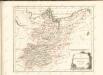

Nord-östliches Deutschland
1 : 1850000 Braniborsko (Německo) Ausfeld, Johann Carl Justus Perthes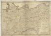
Die Königreiche Sachsen und Westphalen nach der neuesten astronomischen Beobachtungen und den besten Hülfsmitteln verfasst
1 : 1060000 Sasko (Německo) Mollo, Tranquillo T. Mollo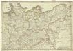
Die Königreiche Sachsen und Westphalen nach der neuesten astronomischen Beobachtungen und den besten Hülfsmitteln verfasst
1 : 1060000 Sasko (Německo) Mollo, Tranquillo T. Mollo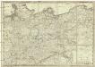
Die Königreiche Sachsen und Westphalen
1 : 1060000 Sasko (Německo) Mollo, Tranquillo T. Mollo
Nord-Östliches Deutschland
Hand-Atlas über alle Theile der Erde und über das Weltgebäude Stieler, Adolf Justus Perthes
Nord-Östliches Deutschland
Handatlas über alle Theile der Erde und über das Weltgebäude Stieler, Adolf Justus Perthes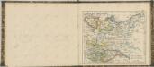

General Karte von denen Ober- und Niedersaechsischen Kreisen nach des D. Büsching Erdbeschreibung u. den besten Hülfsmitteln entworffen
1 : 1150000 [Augsburg] : bey Joh. Walch
[Nordöstliches Deutschland]
Schul-Atlas über alle Theile der Erde nach dem neuesten Zustande, und über das Weltgebäude Stieler, Adolf bei Justus Perthes
Nordöstliches Deutschland
Preußen
Nord-Ostliches Deutschland bearbeitet von C. Vogel.
1 : 1850000 Vogel, C.
Übersichts-Karte des Donau-Moldau-Elbe-Canals
1 : 1250000 Dunaj (řeka : povodí)
Upper Saxony.
1 : 2900000 Bowen, Frances
Die Königl. Preussischen Provinzen Brandenburg Pommern Sachsen und Schlesien nebst Mecklenburg
Mitteleuropa
Postkarte von dem Obersaechsischen und Niedersaechsischen Kreise
Polsko severozápadní Kühn, Ignaz im von Reilly'schen Landkarten und Kunstwerke Verschleiss Komptoir
NO Deutschland.
1 : 5500000 Brudin, J. L.; Stieler, Adolf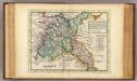
The N.E. part of Germany.
1 : 3500000 Moll, Herman, d. 1732
Situation des armées Francaises depuis le 10 mars jusqu'á la bataille de Wurtchen (Campagne de 1813)
1 : 2281000
The N. E. Part of Germany
1 : 3400000 Mollova mapová sbírka Moll, Herman Moll, Hermann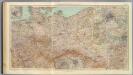
53-55. Germania nord.
1 : 1500000 Touring club italiano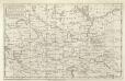
A Map of the Seat of War in Germany &c.
Mollova mapová sbírka Bennett Dilly, Charles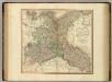
Upper Saxony, Silesia, Lusatia.
1 : 1340000 Cary, John, ca. 1754-1835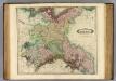
Upper Saxony.
1 : 1500000 Lizars, Daniel
A map of Upper Saxony comprehending that part of Germany which is the present seat of war
1 : 2534400
NE pt. of Germany.
1 : 3150000 Bowen, Emanuel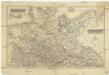
![[Nord-Östliches Deutschland]](https://images-2.georeferencer.com/images/iiif/706167932317/full/,300/0/native.jpg)

