Maps of Germany

53-55. Germania nord.
1 : 1500000 Touring club italiano
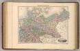
Nord-Deutschland
E. von Sydow's Schul-Atlas in sechs und dreissig Karten Sydow, Emil von bei Justus Perthes
Norddeutsche Bundesstaaten
Evropa střední
Tableau l'historie du Royaume de Prusse.
1 : 6000000 Duval, Henri
Charte des gegenwärtigen Kriegs in Teutschland ou la Guerre presente
1 : 2800000 Mollova mapová sbírka Friedrich, Jacob Andreas Frédéric, Jacques-André
Charte des gegenwärtigen Kriegs in Teutschland ou la Guerre presente
1 : 2800000 Mollova mapová sbírka Friedrich, Jacob Andreas Frédéric, Jacques-André
Norddeutsche Bundesstaaten
Evropa střední
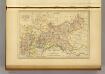
Prussia.
1 : 4118400 Tallis, J. & F.
Prussia.
1 : 3200000 Mitchell, Samuel Augustus
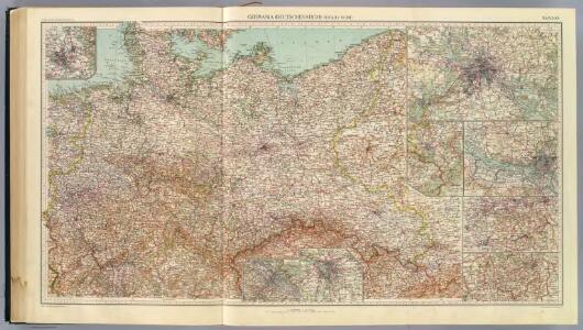
Deutchland
Allemagne du Nord.
1 : 2650000 Migeon, J.
Germania Ptolemaei
1 : 3600000 Mollova mapová sbírka Weigel, Christoph Weigel, Christoph I.
Karte des Central-Kriegsschauplatzes in Deutschland
1 : 2000000 Evropa střední Eduard Hölzel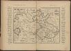
Říše Česká za Karla IV
Tschechische Republik Polen Böhmen Karl IV.
Preussen, Neuchatel, Valengin.
1 : 3200000 Radefeld, Carl Christian Franz, 1788-1874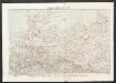
Nord-Deutschland
Geographischer Atlas über alle Theile der Erde Ziegler, Jakob Melchior Verlag von Joh. Wurster um Comp.
Prussian States.
1 : 5200000 Arrowsmith, Aaron; Lewis, Samuel
Carte Generale du Royaume de Prusse.
1 : 3000000 Vivien de St Martin, L.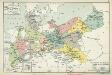
XI. Die Provinzen des Königreichs Preußen mit den Regierungsbezirken
Preußen Verwaltungsgliederung
Politische Übersicht von Nord-Deutschland und Preussen
E. von Sydow's Schul-Atlas in sechs und dreissig Karten Sydow, Emil von bei Justus Perthes
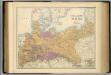
Die Preussische Monarchie
Preußen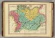
Germania Antiqua. (1826)
1 : 4400000 Tanner, Henry S.
North German Confederation and Prussia.
1 : 2217600 Fullarton, A. & Co.
Regni Borussiae et Electoratus Brandenburgici, Ceterarum que, Quae Fridirici Reg. Bor. sceptro reguntur nec non finitimarum Prov. Delineatio
1 : 2000000 Mollova mapová sbírka Schenk, Pieter Schenk, Peter I
Regni Borussiae et Electoratus Brandeburgici, Ceterarumque Quae Friderici Regis Boruss. sceptro reguntur nec non finitimarum Provinciarum Delineatio
1 : 2000000 Mollova mapová sbírka Halma, François Halma, Franciscus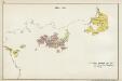
III. 1608 - 1619
Brandenburg Expansion
Karte vom Preussischen Staate mit den Bundesstaaten in Nord-Deutschland
1 : 2400000 Neuchâtel (Švýcarsko) Bimbé, Wilhelm K.A. Kümmel
VI. 1740 - 1786
Preußen