Maps of Syria

Carte de la Syrie
Nouvel atlas physique politique et historique de l'Empire ottoman et des états limitrophes en Europe, en Asie et en Afrique, en quarante feuilles Hellert, J.J. Bellizard, Dufour et Cie
Syria and the Provinces to the Persian Gulf.
1 : 3380000 Sharpe, J.
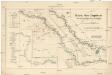
Euphrates Valley, Syria, Kurdistan &c.
1 : 3220177 Stanford, Edward
149-150. East Mediterranean Lands and Iraq. Baghdad. The World Atlas.
1 : 2500000 USSR (Union of Soviet Socialist Republics).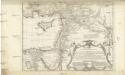
Typvs AEtiologicvs
1 : 3900000 Blízký východ Hase, Johann Matthias Luca, Paulus in officina Homan[n]iana
Typvs AEtiologicvs
1 : 3900000 Blízký východ Hase, Johann Matthias Luca, Paulus in officina Homan[n]iana
Assyria vetvs divisa in Syriam, Mesopotamiam Babyloniam, & Assyriam proprie dictam
Asýrie La Rue, Philippe de Mortier, Pieter apud Pet. Mortier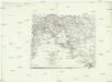
Euphrat und Tigris
1 : 2500000 Eufrat-oblast Anville, Jean-Baptiste Bourguinon d' Schraembl, Franz Anton F.A. Schraembl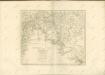

Places Recorded in the Five Books of Moses.
1 : 4700000 Finley, Anthony
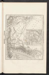
Syria.
1 : 3801600 Tallis, J. & F.
Syria.
1 : 6500000 Fenner, Rest.
Syria to Sinai.
1 : 2200000 Society for the Diffusion of Useful Knowledge (Great Britain)
Syriae.
1 : 2400000 Vivien de St Martin, L.
Ancient Syria
1 : 2200000 Blízký východ Hughes, William Chapman & Hall
Feuille 41 (F VI), uit: Carte géologique internationale de l'Europe : la carte, votée au congrès géologique international de Bologne en 1881, est exécutée conformément aux décisions d'une commission internationale, avec le concours des gouvernements, sous le dir. de M.M. Beyrich et Hauchecorne
Annotatie: Blad 48 gamme des couleurs; blad 49: bladwijzer en titelblad Heinrich Ernst Beyrich 1815-1896; Wi. Hauchecorne Berlin : Reimer / (Berlin: Institut lithographique)
Die sogenannten Missionen der Central-TürkeiDas Gebiet der Nestorianer

Afbeelding van 't Koningryk Israëls, benevens de door 't zelve overheerde landen; gedurende de regering der koningen Saul, David, en Salomo
1 : 2300000 door W.A. Bachiene J. van Jagen mapp. sculpsit, et figur. apposit. sculpturam curavit ; J. Folkema f. Uitgegeven te Gorinchem : by Nicolaas Goetzee
Ancient Syria to Sinai.
1 : 2200000 Society for the Diffusion of Useful Knowledge (Great Britain)
Syria
1 : 2200000 Hughes, William, 1817-1876 George Cox
Die Reiche der Kreuzfahrer um 1142
Kreuzfahrerstaaten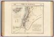
Syrie et Palestine. Asie 63.
1 : 1641836 Vandermaelen, Philippe, 1795-1869
Feuille No. 9, uit: Carte de la Turquie d'Asie (moins l'Arabie) / dessiné et héliogravé au Service géographique de l'Armée
1 : 1000000 titelvariant: Turquie d'Asie; Annotatie: Titel boven de kaart: Turquie d'Asie; Bl. genummerd 1-4 en 7-10; Met lijst van de meest gebruikte woorden op de kaart vertaald uit het Turks, Arabisch en Perzisch; Annotatie geografische gegevens: Inzetkrt. op bl. 9: Plan de Jérusalem et de ses environs, Plan d'Alep, Plan de Damas et de ses faubourgs, Plan de Beyrout et de ses environs (alle 1:50.000) Service géographique de l'Armée [S.l. : Service géographique de l'Armée]
Die Reiche der Kreuzfahrer um 1142
Levante, Kreuzfahrerstaaten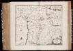
Syriæ, sive Soriæ : nova et accurata descriptio
1 : 1300000 Annotatie: Kaart vervaardigd in ca. 1658; Kaart uitg. tussen ca. 1658-ca. 1680; Origineel is Blad 182 in atlas factice; Annotatie geografische gegevens: Schaalstokken op kaart: 15 Milliaria Germanica Communia (=8,3 cm), en: 20 Milliaria Gallica Communia (=8,3 cm) Johannes Janssonius 1588-1664 Amstelodami : sumptibus Ioannis Ianssonii
Syrie et de la Palestine, 624 ans apres J.C.
1 : 3300000 Houze, Antoine Philippe
Palaestina
Grosser Hand-Atlas über alle Theile der Erde in 170 Karten Meyer, J. Verlag des Bibliographischen Instituts
Syrien und die angraenzenden Laender zur Zeit der Kreuzzuge.
1 : 3000000 Spruner von Merz, Karl
La nvova et esatta descrittione della Soria, e della Terra Santa
Kypr Forlani, Paolo da Paulo Furlani Veronese