Maps of Rheinland-Pfalz

Die Preussische Rhein-Provinz und das Herzogthum Nassau
Grosser Hand-Atlas über alle Theile der Erde in 170 Karten Meyer, J. Verlag des Bibliographischen Instituts

S.R.I. circulos Rhenanus inferior sive electorum Rheni
1 : 632000 Kolín nad Rýnem-oblast (Německo) Homann, Johann Baptist â Ioh. Baptista Homanno
Kreise der Rheinprovinz 1864
Preußen, Rheinprovinz, Verwaltungsgliederung Kunz, Andreas ; Moeschl, Joachim Robert
S. R. I. circulus Rhenanus inferior sive electorum Rheni
1 : 624000 Kolín nad Rýnem (Německo) Homann, Johann Baptist I. B. Homann
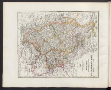
Rhein-Provinz, Nassau.
1 : 980000 Radefeld, Carl Christian Franz, 1788-1874
Synopsis Circuli Rhenani Inferioris sive Electorum Rheni, exhibens Archi Episcopatum Moguntinum, Coloniensem, Trevirensem et Palatinatum Rheni, Comitatus Beilstein, Newenaer, Isenburg Infer. et Reifferscheid
1 : 800000 ob oculos posita a Matth. Seutter Aug. Vind : Matth. Seutter
Rheinprovinz, Westfalen, Hessen-Nassau, Waldeck, Grossherzogthum Hessen.
1 : 1000000 Andree, Richard
Geologische Übersichtskarte der Rheinprovinz und der Provinz Westfalen / bearb. von H. von Dechen
1 : 500000 Annotatie: Oorspr. uitg.: 1866 Heinrich von Dechen Berlin : Schropp
Das Kriegstheater an der Rhein & Mainlinie
1 : 990000 Porýní-Falc (Německo) Meyer, A. litogr. Maschinendruck von A. Meyer
Rhein Provinz.
1 : 825000 Flemming, Carl
Geologische Übersichtskarte der Rheinprovinz und der Provinz Westfalen / bearb. von H. von Dechen
1 : 500000 Heinrich von Dechen Berlin : Schropp
Synopsis circuli Rhenani inferioris sive electorum Rheni
1 Karte : Kupferdruck ; 48 x 55 cm Lotter Tobias Konrad Lotter
Synopsis circuli Rhenani inferioris sive electorum Rheni
1 Karte : Kupferdruck ; 48 x 56 cm Seutter Matthäus Seutter
Synopsis Circuli Rhenani Inferioris, Sive Electorum Rheni
1 : 620000 Mollova mapová sbírka Seutter, Matthäus Seutter, Matthäus
Synopsis circuli Rhenani inferioris sive electorum Rheni
1 : 620000 Porýní-Falc (Německo) Lotter, Tobias Conrad Tobias Conrad Lotter
Synopsis circuli Rhenani inferioris sive electorum Rheni
1 : 620000 Porýní-Falc (Německo) Lotter, Tobias Conrad T. C. Lotter
Synopsis circuli Rhenani inferioris sive electorum Rheni
1 : 620000 Porýní-Falc (Německo) Lotter, Tobias Conrad Tobias Conrad Lotter
SYNOPSIS CIRCULI RHENANI INFERIORIS sive ELECTORUM RHENI
1 : 640000 Porýní-Falc (Německo) Seutter, Matthäus a Matth. Seutter
Synopsis circuli Rhenani inferioris sive electorum Rheni
1 : 620000 Porýní-Falc (Německo) Seutter, Matthäus Matthäus Seutter
Teutschlands Nieder Rheinischer Creiss mit seinen abgetheilten Provintzen
1 : 2600000 Mollova mapová sbírka Weigel, Christoph Weigel, Christoph I.
Dioecesis Coloniensis
1 : 650000 Kolín nad Rýnem-oblast (Německo)
Die Rheinlande nach ihren geologischen Beziehungen
1 : 560000 Leonhard, Gustav E. Schweizerbart's Verlagshandlung
Tabula Nova Circuli Electoralis Rheni, ad Usum Serenissimi Burgundae Ducis
1 : 670000 Mollova mapová sbírka Jaillot, Alexis-Hubert Ottens, Josua
Tabula Nova Circuli Electoralis Rheni, ad Usum Serenissimi Burgundae Ducis
1 : 670000 Mollova mapová sbírka Jaillot, Alexis-Hubert Jaillot, Alexis Hubert
Carte des cercles du Haut et Bas Rhin
1 : 1000000 Alsasko (Francie) Mentelle, Edme Tardieu, Pierre François
Le Cercle Eslectorial Du Rhein subdivié entous les Estats qui le composent [Karte], in: Atlas nouveau, contenant toutes les parties du monde [...], Bd. 1, S. 290.
1 Karte aus Atlas Sanson, Nicolas Jaillot, Alexis Hubert und Mortier, Pieter

Die Preussische Provinz Sachsen
1 : 600000 Geographisches Institut (Weimar, Germany)