Maps of Rhineland-Palatinate

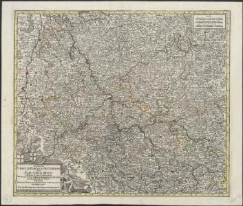
Synopsis Circuli Rhenani Inferioris sive Electorum Rheni, exhibens Archi Episcopatum Moguntinum, Coloniensem, Trevirensem et Palatinatum Rheni, Comitatus Beilstein, Newenaer, Isenburg Infer. et Reifferscheid
1 : 800000 ob oculos posita a Matth. Seutter Aug. Vind : Matth. Seutter
Synopsis circuli Rhenani inferioris sive electorum Rheni
1 : 620000 Porýní-Falc (Německo) Lotter, Tobias Conrad Tobias Conrad Lotter
Synopsis circuli Rhenani inferioris sive electorum Rheni
1 : 620000 Porýní-Falc (Německo) Lotter, Tobias Conrad T. C. Lotter
Synopsis circuli Rhenani inferioris sive electorum Rheni
1 : 620000 Porýní-Falc (Německo) Lotter, Tobias Conrad Tobias Conrad Lotter
SYNOPSIS CIRCULI RHENANI INFERIORIS sive ELECTORUM RHENI
1 : 640000 Porýní-Falc (Německo) Seutter, Matthäus a Matth. Seutter
Synopsis circuli Rhenani inferioris sive electorum Rheni
1 : 620000 Porýní-Falc (Německo) Seutter, Matthäus Matthäus Seutter
Synopsis circuli Rhenani inferioris sive electorum Rheni
1 Karte : Kupferdruck ; 48 x 55 cm Lotter Tobias Konrad Lotter
Synopsis circuli Rhenani inferioris sive electorum Rheni
1 Karte : Kupferdruck ; 48 x 56 cm Seutter Matthäus Seutter
S. R. I. circulus Rhenanus inferior sive electorum Rheni
1 : 624000 Kolín nad Rýnem (Německo) Homann, Johann Baptist I. B. Homann
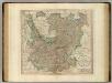
Carte des cercles du Haut et Bas Rhin
1 : 1000000 Alsasko (Francie) Mentelle, Edme Tardieu, Pierre François
S.R.I. circulos Rhenanus inferior sive electorum Rheni
1 : 632000 Kolín nad Rýnem-oblast (Německo) Homann, Johann Baptist â Ioh. Baptista Homanno
Rhein Provinz.
1 : 825000 Flemming, Carl
Synopsis Circuli Rhenani Inferioris, Sive Electorum Rheni
1 : 620000 Mollova mapová sbírka Seutter, Matthäus Seutter, Matthäus
Upper, Lower Rhine circles.
1 : 700000 Cary, John, ca. 1754-1835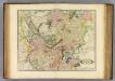
Upper, Lower Rhine.
1 : 720000 Lizars, Daniel
S.R.I. circulus Rhenanus inferior sive electorum Rheni
1 : 640000 Dolní Porýní (Německo) Homann, Johann Baptist a Ioh. Baptista Homanno
S.R.I. circulus Rhenanus inferior sive electorum Rheni
1 : 640000 Dolní Porýní (Německo) Homann, Johann Baptist a Ioh. Baptista Homanno
S.R.I. circulus Rhenanus inferior sive electorum Rheni
1 : 640000 Dolní Porýní (Německo) Homann, Johann Baptist a Ioh. Baptista Homanno
S. R. I. circulus Rhenanus inferior sive electorum Rheni
1 : 660000 Kolín nad Rýnem (Německo) Homann, Johann Baptist J.B. Homann
S.R.I. circulus Rhenanus inferior sive electorum Rheni
1 : 640000 Dolní Porýní (Německo) Homann, Johann Baptist á Ioh. Baptista Homanno
Der Chur Rheinsiche- oder Nieder Rheinische Kreis
1 : 620000 Porýní-Falc (Německo) Güssefeld, Franz L. bey den Homännischen Erben
Der Chur Rheinsiche- oder Nieder Rheinische Kreis
1 : 620000 Porýní-Falc (Německo) Güssefeld, Franz L. bey den Homännischen Erben
Rheinprovinz, Westfalen, Hessen-Nassau, Waldeck, Grossherzogthum Hessen.
1 : 1000000 Andree, Richard
Rhenish Prussia, Westphalia, Hesse-Nassau, Waldeck, Lippe, Hesse.
1 : 1000000 Andree, Richard; Times (London, England)
Die Rheinlande nach ihren geologischen Beziehungen
1 : 560000 Leonhard, Gustav E. Schweizerbart's Verlagshandlung
Geologische Übersichtskarte der Rheinprovinz und der Provinz Westfalen / bearb. von H. von Dechen
1 : 500000 Annotatie: Oorspr. uitg.: 1866 Heinrich von Dechen Berlin : Schropp
Die Preussische Rhein-Provinz und das Herzogthum Nassau
Grosser Hand-Atlas über alle Theile der Erde in 170 Karten Meyer, J. Verlag des Bibliographischen Instituts
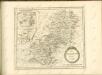
Dioecesis Coloniensis
1 : 650000 Kolín nad Rýnem-oblast (Německo)