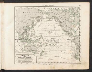
Maps of Polynesia

Grosser oder Stiller Ocean
E. von Sydow's Schul-Atlas in sechs und dreissig Karten Sydow, Emil von bei Justus Perthes
Americae nova Tabula. [Karte], in: Le théâtre du monde, ou, Nouvel atlas contenant les chartes et descriptions de tous les païs de la terre, Bd. 2, S. 298.
1 Karte aus Atlas Blaeu, Willem Janszoon und Blaeu, Joan Blaeu, Willem Janszoon
Streams, currents and drifts in the Pacific Ocean : mainly from the British Admirality chart No. 2640
1 : 33000000 United States. Hydrographic Office Hydrographic Office
Mappemonde ou Carte générale de l' univers sur une projection nouvelle d'une sphére ovale pour mieux entendre les distances entre l'Europe et Amerique : avec le tour du monde du lieut. Cook et tous les découvertes nouvelles
1 : 45000000 dessinée et gravée par Mathieu Albert Lotter A Augsbourg : [s.n.]
Versuch einer Karte zur Übersicht der Fluthwellen
Erster Band, enthaltend in vier Abtheilungen die Erscheinungen der anorganischen Natur: 1. Meteorologie und Klimatographie. 2. Hydrologie und Hydrographie. 3. Geologie. 4. Tellurischer Magnetismus Humboldt, Alexander von Verlag von Justus Perthes
Map of the World.
1 : 85000000 Rand McNally and Company
Kaart der oude waereld tot verstand van het XXI boek van den Geest der wetten
1 : 40000000 J.C. de Roeder delin. H. Klockhoff sculp. Te Amsterdam : bij Holtrop
Vulkane, Koralleninseln.
1 : 110000000 Andree, Richard
[Historisch-geographischer Atlas zu den allgemeinen Geschichtswerken von C. v. Rotteck, Pölitz u. Becker] : Erdansichten nach den im Mittelalter herrschenden Systemen
von Julius Loewenberg [Freiburg im Breisgau] : [Herder]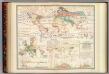
Distribution: plants.
1 : 67000000 Johnston, Alexander Keith, 1804-1871
Oestlicher Planiglob der Erde
1 : 17000000 Weimar : Verlag des Geographischen Instituts
Navigation, les oceans.
1 : 67000000 Garnier, F. A., 1803-1863
Thermometrie.
1 : 70000000 Garnier, F. A., 1803-1863
Versuch Einer Karte Zur ?bersicht Der Fluthwellen.
1 : 95000000 Berghaus, Heinrich
Kaart der ontdekkingen gedaan door kapitein James Cook op zijne drie reistogten, met aanwijzing der koers van de schepen welke onder zijn bevel stonden
1 : 80000000 Van Baersel en Tuyn del. lithografie van R. de Vries Jr. ; naar het ontwerp van den Engelschen Luitenant ter Zee, H. Roberts [S.l.] : [s.n.]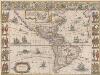
Americae nova Tabula. [Karte], in: Theatrum orbis terrarum, sive, Atlas novus, Bd. 2, S. 307.
1 Karte aus Atlas Blaeu, Joan Blaeu, Willem Janszoon
Karte für die in den Jahren 1827-1831 Beobachteten Werthe der Declination
Erster Band, enthaltend in vier Abtheilungen die Erscheinungen der anorganischen Natur: 1. Meteorologie und Klimatographie. 2. Hydrologie und Hydrographie. 3. Geologie. 4. Tellurischer Magnetismus Humboldt, Alexander von Verlag von Justus Perthes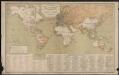
Carte générale des lignes télégraphiques internationales
1 : 40000000 Jaccottey, Paul Paris : Ch. Delagrave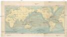
Uebersicht der Strömungen des Meeres
země světa Christmann, Fr. Hartwig Meidinger Sohn
Verbreitung des Katzen-Geschlechts, Genus-Felis, so wie der Hyane.
1 : 115000000 Berghaus, Heinrich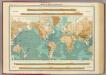
World - bathy-orographical.
1 : 83000000 John Bartholomew and Son
Welt-Karte zur Ubersicht der Luft-Stromungen und der See-Wege.
1 : 115000000 Berghaus, Hermann
Welt-Karte zur Ubersicht der Meeres-Stromungen und des Schnellverkehrs.
1 : 115000000 Berghaus, Hermann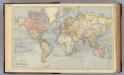
The World.
1 : 65000000 Letts, Son & Co.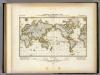
Darstellung Der Isodynamischen Linien.
1 : 130000000 Berghaus, Heinrich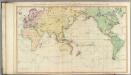
General chart.
1 : 45000000 Roberts, Henry, Lieut.
India Extrema; XIX. Nova Tabula. [Karte], in: Claud. Ptolemaeus. Geographia lat. cum mappis [...], S. 413.
1 Karte aus Atlas Münster, Sebastian [und Ptolemaeus, Claudius]
I. Charte für die allgemeine Geschichte von den frühesten bekannten Zeiten bis zur Zerstörung von Troja
Entworfen von F.W. Benicken Weimar : im Verlage des L. Industrie-Comptoirs
[Botanical Geography]
The physical atlas Johnston, Alexander Keith William Blackwood & Sons