Maps of Lucerne

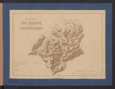
Kantone Uri, Schwyz und Unterwalden
1 : 1450000 [Stumme Kartenskizzen der ganzen Schweiz und der einzelnen Kantone zu Unterrichtszwecken] Schulbuchhandlung Antenen
Zürich
1 : 200000 1 Karte entworfen und bearbeitet von Woerl ; in Stein gestochen unter seiner Leitung 1834 ; Lithographie von B. Herder Herder, Freiburg im Breisgau
Argow cum parte merid. Zurichgow [Karte], in: Le théâtre du monde, ou, Nouvel atlas contenant les chartes et descriptions de tous les païs de la terre, Bd. 1, S. 285.
1 Karte aus Atlas Blaeu, Willem Janszoon und Blaeu, Joan Blaeu, Willem Janszoon
Reliefkarte der Centralschweiz
1 Vogelschaukarte construirt und gezeichnet von X. Imfeld ; hrsg. vom Verein zur Förderung des Fremdenverkehrs am Vierwaldstättersee und Umgebung Wurster, Zürich
Tugeni in Helvetiis
1 : 250000 Mollova mapová sbírka Sanson, Nicolas Liébaux, Jean-Baptiste Mariette, Pierre
Argow
1 Karte : Kupferdruck ; 14 x 18 cm s.n.
[Luzern, Zug, Uri, Schwyz, Unterwalden, Glarus, Teile Aargau und Zürich] [Karte], in: Gerardi Mercatoris Atlas, sive, Cosmographicae meditationes de fabrica mundi et fabricati figura, S. 270.
1 Karte aus Atlas Mercator, Gerhard Montanus, Petrus
Argow cum parte merid. Zvrichgow
1 Karte : Kupferdruck ; 37 x 48 cm Mercator; Janssonius Joannes Janssonius
Argow cum parte merid. Zvrichgow
1 Karte : Kupferdruck ; 37 x 48 cm Mercator; Schenk; Valck apud G. Valk et P. Schenk
Argow cum parte merid. Zvrichgow
1 Karte : Kupferdruck ; 37 x 49 cm Blaeu; Mercator Willem Janszoon Blaeu
[Argow]
1 Karte : Kupferdruck ; 34 x 45 cm Mercator; Hondius Henricus Hondius
[Argow]
1 Karte : Kupferdruck ; 34 x 45 cm Mercator s.n.
[Exactissima Helvetiae, Rhaetiae, Valesiae ... tabula]
1 : 850000 9 Karten [Kopie von Adrian Braakman] [chez Pierre Schenk et Adrian Braakman], [Amsterdam]
Argow cum parte merid. Zvrichgow
1 : 310000 Mollova mapová sbírka Mercator, Gerhard Schenk, Peter I
Argow cum parte merid. Zvrichgow
1 : 320000 Mollova mapová sbírka Mercator, Gerhard Blaeu, Joan I.
Argow cum parte merid. Zurichgow [Karte], in: Theatrum orbis terrarum, sive, Atlas novus, Bd. 1, S. 297.
1 Karte aus Atlas Blaeu, Joan Blaeu, Willem Janszoon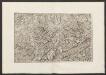
Militair Karte von Süd-Deutschland in 20 Sectionen
1 : 400000 17. Section Coulon, Alois von A. von Coulon
[Argow] [Karte], in: Gerardi Mercatoris et I. Hondii Newer Atlas, oder, Grosses Weltbuch, Bd. 1, S. 265.
1 Karte aus Atlas Mercator, Gerhard und Hondius, Jodocus Jansson, Jan
<<Das>> Zürychgow
1 : 400000 1 Karte [Johannes Stumpf]
Argow cum parte merid. Zurichgow [Karte], in: Novus Atlas, das ist, Weltbeschreibung, Bd. 1, S. 254.
1 Karte aus Atlas Blaeu, Joan Blaeu, Willem Janszoon
Reliefkarte der Centralschweiz
Imfeld, Xaver J. Wurster & Cie.
ARGOW | cum parte merid. | ZVRICHGOW
Auctore Ger. Mercatore. [Amsterdam : Joan Blaeu]

Tschudi's Touristenkarte der Centralschweiz
1 : 250000 1 Karte Stich u. Druck: Wurster, Randegger Scheitlin & Zollikofer, St. Gallen
<<Der>> Canton Luzern
1 : 270000 1 Karte gezeichnet v. Jost Pfyffer v. Altishofen ; gest. v. J. Scheurmann Orell Füssli & Comp., Züric [i.e. Zürich]
<<Der>> Canton Luzern
1 : 270000 1 Karte gezeichnet v. Hr. Jost Pfyffer v. Altishofen Oberstl. d. Artill. ; gest. v. J. Scheurmann Orell, Füssli & Comp. Libraires & Marchands d'Estampes, Züric [i.e. Zürich]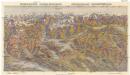
Zentralschweiz - Central Switzerland
Alpy švýcarské Erva
[Reliefkarte der Centralschweiz]
Imfeld, Xaver [Wurster, Randegger]
Partie du Canton de Lucerne d'Unterwalden d'Uri et Zurich le Canton Glarus Schweiz et Zug.
From Atlas Suisse. Levé et dessiné par J. H. Weiss aux fraix de J. R. Meyer á Aarau dans les années 1786 á 1802. Gravée par Guerin, Eichler, et Scheurmann.